Raymarine E series showing wrong date

longjohnsilver

Well-known member
Joined
30 May 2001
Messages
18,841
Visit site
When looking for tidal data my E series for some unknown reason has started showing the wrong date. I can get the correct data by manually inputting the date I want, but this is a new error. See pic below, bottom left hand corner.
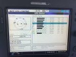
2BD2D340-F958-4809-9605-1A80379CBAD3.jpeg

Any ideas on what I can do to correct this error? I tried a restart of the gps, and turning the unit off and on, but nothing changed. Everything else on the chartplotter seems to be working normally.
 

Slipstream 34

Active member
Joined
15 Feb 2006
Messages
639
Location
Clyde
Visit site
Does it get a fix quickly? If not the battery in the gps may be flat and it loses the latest almanac data.
 
Last edited:

robmcg

Well-known member
Joined
17 Sep 2006
Messages
1,840
Location
In exile in Scotland
Visit site
I suspect it's what Slipstream 34 above says. We had a Furuno gps that did a similar thing which was apparently a GPS rollover issue but I suspect this isn't the case here. Bizarrely, on the Furuno, even though the date was wrong, the position was always bang on.
 

Hoist

Active member
Joined
28 Nov 2019
Messages
173
Visit site
there is no internal battery in the E120.

the time and date is taken from the GPS antenna thats why its shown on the GPS status page

I would do a factory reset. Turn the machine on and hold the furthest left soft key as well as the power button on and FACTORY RESET 3 2 1 will appear

you will lose tracks logs etc but that sorts a lot of problems.
 

pvb

Well-known member
Joined
16 May 2001
Messages
45,603
Location
UK East Coast
Visit site
When looking for tidal data my E series for some unknown reason has started showing the wrong date. I can get the correct data by manually inputting the date I want, but this is a new error. See pic below, bottom left hand corner.

Any ideas on what I can do to correct this error? I tried a restart of the gps, and turning the unit off and on, but nothing changed. Everything else on the chartplotter seems to be working normally.

What type of GPS receiver is feeding the plotter?
 

martyn Eustace

New member
Joined
13 Nov 2022
Messages
10
Visit site
When looking for tidal data my E series for some unknown reason has started showing the wrong date. I can get the correct data by manually inputting the date I want, but this is a new error. See pic below, bottom left hand corner.

View attachment 112890

Any ideas on what I can do to correct this error? I tried a restart of the gps, and turning the unit off and on, but nothing changed. Everything else on the chartplotter seems to be working normally.
I have the same plug them with my E1 20 plotter. Lost correct date and time.
Conversations with Raymarine and dealer are provided solutions such as, change the battery in the E1 20 unit (which I see from this red does not have one), to change the GPS aerial from C1 20 to see 150.
I thought I would ask if this thread resulted in solutions which got your date and time back?
Appreciate information.
 

DipperToo

Active member
Joined
7 Jan 2005
Messages
679
Location
Now a formal berth at Northney
Visit site
If you have the Raystar 125 GPS, that is the issue - in March this year it fails with the date and reverts back to August 2001 as per your picture. However, the position data should be OK.
Depending on what else is connected to your plotter, you can input NMEA at 4800 from a generally available GPS receiver ( around £90 or so). The old classic raymarine plotters 'should' output this onto the seatalk bus. However, you MUST remove the Raystar 125 as if the plotter detects gps data on the seatalk bus, that takes precedence.
I have a Camino AIS transponder which has its own GPS and there is a setting which outputs that GPS data with the AIS data at 38400 baud into my old C80 and that works. I believe that the E120 has more connection options for nmea that the old C80 so there may be more flexibility.
I have not yet removed the 125 unit so will check in a few weeks time if the C80 does in fact pass the data through. An alternative is that if you have one of the raymarine multiplexors, that can take nmea from a new GPS receiver and pit in across onto the seatalk bus.
 

DipperToo

Active member
Joined
7 Jan 2005
Messages
679
Location
Now a formal berth at Northney
Visit site
Here is the document I posted on another thread. It clearly shows all devices affected . The Rs125 sadly must be replaced.
Do NOT rely on tidal data on your plotter unless you specifically change the date to the single tidal instance you are looking at. If you fail to correct the date you may well run aground or take far longer on a passage if you rely on the built-in tidal data without adjusting the date.
 

Attachments

  • GPS Rollover table (2).pdf
    175.2 KB · Views: 43
Last edited:

martyn Eustace

New member
Joined
13 Nov 2022
Messages
10
Visit site
If you have the Raystar 125 GPS, that is the issue - in March this year it fails with the date and reverts back to August 2001 as per your picture. However, the position data should be OK.
Depending on what else is connected to your plotter, you can input NMEA at 4800 from a generally available GPS receiver ( around £90 or so). The old classic raymarine plotters 'should' output this onto the seatalk bus. However, you MUST remove the Raystar 125 as if the plotter detects gps data on the seatalk bus, that takes precedence.
I have a Camino AIS transponder which has its own GPS and there is a setting which outputs that GPS data with the AIS data at 38400 baud into my old C80 and that works. I believe that the E120 has more connection options for nmea that the old C80 so there may be more flexibility.
I have not yet removed the 125 unit so will check in a few weeks time if the C80 does in fact pass the data through. An alternative is that if you have one of the raymarine multiplexors, that can take nmea from a new GPS receiver and pit in across onto the seatalk bus.
Thank you, dippertoo.
Today, I changed the Raystar 125 battery. (There is one!!). It wasn’t too difficult and I thought I would at least give it a go in order to see if the time on my Raymarine E120 plotter started to show again. It doesn’t! But GPS positioning is good and I can manually change the date on the plotter for title data. I can cope with this.
Can anybody tell me why there is a battery in the Raystar 125 unit? It must’ve failed a long time ago - with seemingly no effect on the operation of the aerial or plotter!
I’ve had conversations with a Raymarine dealer who suggests updating the system with a new aerial and some sort of converter so that my plotter can read it. With rerouting of cables and new kit ill cost a lot of money for little benefit.
If you, or anyone, finds a simple solution, I’ll be glad to hear!
Thanks all!
 

masterofnone

Active member
Joined
24 Feb 2004
Messages
722
Location
Newhaven. East Sussex
Visit site
Here is the document I posted on another thread. It clearly shows all devices affected . The Rs125 sadly must be replaced.
Do NOT rely on tidal data on your plotter unless you specifically change the date to the single tidal instance you are looking at. If you fail to correct the date you may well run aground or take far longer on a passage if you rely on the built-in tidal data without adjusting the date.
Yesterday 14/06/2023. I looked at the tidal curve for my position , mea culpa , default date 2003. 4 hrs enjoying the view.
 

DipperToo

Active member
Joined
7 Jan 2005
Messages
679
Location
Now a formal berth at Northney
Visit site
Thank you, dippertoo.
Today, I changed the Raystar 125 battery. (There is one!!). It wasn’t too difficult and I thought I would at least give it a go in order to see if the time on my Raymarine E120 plotter started to show again. It doesn’t! But GPS positioning is good and I can manually change the date on the plotter for title data. I can cope with this.
Can anybody tell me why there is a battery in the Raystar 125 unit? It must’ve failed a long time ago - with seemingly no effect on the operation of the aerial or plotter!
I’ve had conversations with a Raymarine dealer who suggests updating the system with a new aerial and some sort of converter so that my plotter can read it. With rerouting of cables and new kit ill cost a lot of money for little benefit.
If you, or anyone, finds a simple solution, I’ll be glad to hear!
Thanks all!
There may be a small chance if there is enough interest for Yakker to make a Seatalk compatible GPS receiver which would just 'drop in' using the existing seatalk network cable that goes to the Raystar 125. It may be worth pinging them an email to see if the project may take off?
http://www.yakbitz.com/
the top right of the page allows you to send an email to Steve who is most helpful.
This approach would allow all of us with the really old legacy C70/80 and some old E series systems to continue working at minimum outlay.
 
Top