Oban to Craobh

davidej

Well-known member
Joined
17 Nov 2004
Messages
6,658
Location
West Mersea. north Essex
Visit site
Forgive my ignorance but I have only been in these waters once. many years ago

I seem to remember that the gap between the two lighthouses west of Luing (Fladda and Dubh Sgeir ??) is a bit like a mill race. But looking at the charts, the alternative passage via the Sound of Cuan doesn't look like a bed of roses either.

Any advice on the best passage plan would be welcome.
 

Bodach na mara

Well-known member
Joined
21 Aug 2002
Messages
2,687
Location
Western Scotland
Visit site
Neither passage is easy first time. Or next time either, but Cuan sound is mor direct and not hard really. The perceived wisdom going west to east is to steer for the Cleit rock at th turn and let the cross tide push you north of it, but I always chicken out and change course about 30 feet from it to pass about 15 feet north. Claymore of this parish can tell you more especially about the other hidden rock north of the Cleit. The rest is straightforward especially when using a plotter as all the rocks are marked. I use Cuan most years and have not hit anything there. Yet.

Seil sound is cleater. But there are lots of eddies especially at the north end. The strongest tide is restricted to the first half mile from the north entrance. The main problem with Seil sound is that the tid can be against you for the last leg accross and up into Craobh.

It is advisable to transit either channel with a favourable tide. Says someone who has found out the hard way.
 

Minerva

Well-known member
Joined
16 Oct 2019
Messages
1,363
Visit site
Y'iv both missed the most important bitty - if you can stop off, stop off at Easdale visitors moorings. The fresh langoustines and seafood there are a delight. The pub's no bad too!
 

awol

Well-known member
Joined
4 Jan 2005
Messages
6,835
Location
Me - Edinburgh; Boat - in the west
Visit site
Neither passage is easy first time. Or next time either, but Cuan sound is mor direct and not hard really. The perceived wisdom going west to east is to steer for the Cleit rock at th turn and let the cross tide push you north of it, but I always chicken out and change course about 30 feet from it to pass about 15 feet north. Claymore of this parish can tell you more especially about the other hidden rock north of the Cleit. The rest is straightforward especially when using a plotter as all the rocks are marked. I use Cuan most years and have not hit anything there. Yet.

Seil sound is cleater. But there are lots of eddies especially at the north end. The strongest tide is restricted to the first half mile from the north entrance. The main problem with Seil sound is that the tid can be against you for the last leg accross and up into Craobh.

It is advisable to transit either channel with a favourable tide. Says someone who has found out the hard way.
You're right, Seil Sound would be ideal except some eejit built a bridge over it. I suspect you meant the Sound of Luing:unsure:
 

dunedin

Well-known member
Joined
3 Feb 2004
Messages
14,066
Location
Boat (over winters in) the Clyde
Visit site
As awol advises, timing of the tides is most important. But with a fair tide, the Sound of Luing is generally very easy - and fast.
In a fresh SW, the bumpy bit is often the stretch from exiting Kerrera Sound to bearing off past Easdale (keeping a safe offing if a lee shore).
Check the buoyage round Bono rock.

Cuan is the more tricky one navigation wise - not just the Cleit Rick but the rocks off the NE exit. Not super tricky, but not in the basic category. And check the chart for the rocks N of Craobh - a surprising number of charter “skippers” seem to exit Craobh without having done their prep and clip the edge of the rock ledge.
NB. Going outbound of the Cuan with the tide into a brisk Westerly can be bumpy and wet for a few minutes, but east inbound.
 

zoidberg

Well-known member
Joined
12 Nov 2016
Messages
6,353
Visit site
You're right, Seil Sound would be ideal except some eejit built a bridge over it. I suspect you meant the Sound of Luing:unsure:

I s'pose you mean this one:

52292625741_ef2ba2c070_n.jpg


There's no a whole lot of water there - but there are moorings nearby, and a pub .... the fabled 'Inn Of The Trouserless'.....
.... and midges^3 !

The 'Sound of Luing is generally very easy - and fast'.... Howeffer, at night in the rain, in a fast trimaran heading south in the midst of a great gaggle of entrants in the Scottish Islands Peaks Race..... now that's a wee bit different!

:cool:
 

ctva

Well-known member
Joined
8 Apr 2007
Messages
4,758
Visit site
Forgive my ignorance but I have only been in these waters once. many years ago

I seem to remember that the gap between the two lighthouses west of Luing (Fladda and Dubh Sgeir ??) is a bit like a mill race. But looking at the charts, the alternative passage via the Sound of Cuan doesn't look like a bed of roses either.

Any advice on the best passage plan would be welcome.
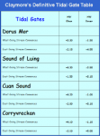
As others have said, Snd of Luing is a straightforward rollercoaster ride, wide and deep enough unless you are a super yacht. Unless you are going south with the tide and there is a south wind. I see plenty going against the tide and have done it myself when the timings are out but it is generally flat and short for the strongest tide before it slackens off further south.
When are you going as I’m heading that way hopefully on Saturday or Sunday so could wave. :)
 

Bilgediver

Well-known member
Joined
6 Jun 2001
Messages
8,193
Location
Scotland
Visit site
You really need a guide such as the one referrenced above or The Yachtsmans's Pilot Isle of Mull and adjacent coasts This covers this area and shows the routes through these hazards and also where other unmarked rocks hide. Might need a mortgage to buy it now as my edition cost £25 many moons ago.

Our ladies team took our St Ayles Skiff down the Clachan Sound. Even they had to wait for water at the north end. Maybe you draw more than 1.0 m and have a mast as there is also the bridge over the Atlantic to consider as reduced headroom. ;) This bypasses the Cuan Sound.
 

dgadee

Well-known member
Joined
13 Oct 2010
Messages
3,986
Visit site
My old next door neighbour did a lot of damage to his keel and mast support going through the Cuan Sound a year or so ago. Do it at slack water and it's easy.
 

RunAgroundHard

Well-known member
Joined
20 Aug 2022
Messages
2,343
Visit site
I find that the Admiralty Tidal Atlases referenced to Dover are accurate for predicting the direction of flow accurately, remember that a tidal atlas refers to the tidal hour, which is +/- 30 minutes each side of the hour e.g. HW Dover is 15:20, the tidal hour is 14:50 to 15:50 for that page on the tidal atlas.

If using plotters my advice is that a Memory Maps, or in particlular Raster charts have more detail than Navionics. UKHO charts at the correct scale are satisfactory. Other chart packages may have better detail that Navionics which is woefully crap at close in zoom levels. I recommend that you buy Memory Maps and Antares Chart package and load onto Memory Maps, about £20 quidish each, superb value. The Antares charts then automatically appear when zooming in on Memory Maps.

The Sound of Luing is very straight forward, just stay in the middle and you will clear any of the shoals near the edges. The approaches are easy. Make sure you use the zoom feature on vector charts to identify the Cardinal Buoys around the Bono Rocks. When passing through the Sound of Insh, again the middle is best as the winds can be quite fluky on either side, but more so on the Seil side, because of the cliffs. Beware the small island at the top of Insh as it has reefs extending from it northwards, north easterly , don't pass close to the islet. As other have said, this passage is safer if there is a strong westerly wind, as the Easdale Bay can be rough with reflected waves, as well as being a lee shore, it is also somewhat exposed to the Atlantic swell, if it is running.

If you do decide to pass through Easdale Sound, as you approach identify the port and starboard beacons. They are rusty poles, substantial in nature. From the Sound of Insh you will be going against the buoyage in the Sound of Easdale. The starboard hand perch, is close to the shore / water edge, below the cliffs of Seil Island. Port hand perch is on a reef and is well set back from the edge of the reef, in the middle of the sound. If you sail close to the port hand perch, you will run aground. Beware local boats, they can transit at speed between rocks because they know where they are going. Do not follow them. Prepare a clearing bearing either from Insh Island or the old ruined pier on the Seil side to avoid the reef extending out from Seil Island, south point. Sail closer to the Seil side, parallel to the shore and when you are abeam the starboard perch (which will be on your port side), head towards the old ruined pier. At the old pier, sail parallel to it. The depth will drop quite suddenly to about 2.5m +tide. As the boat clears the old pier, head to stay about a couple of boat lengths away from the starboard hand perch with a can on top. off the Seil Island shore. It is a steel lattice structure, on its last legs, but has been for decades. One day I expect it will be gone. Sail straight into Easdale Bay and when in 10m or more, put more south in your course to avoid the Seil shore and off flying rocks. Beware, the direct line between the Sound of Easdale and the Cuan Sound, will take you very close to a reef. I tend to aim for the southerly power cable pylon, on Luing, to keep it open on my port bow and sail towards the Luing shore. The worst reefs are very close to the entrance of the Cuan Sound, on the Seil side.

As you enter the Cuan Sound, stay in the middle and immediately start looking for the Cleit Rock yellow perch with triangle top mark. It can look black in colour because of weed and the Scottish dankness that absorbs all colour. Use your binoculars, it's what they are for! If you are in the middle of the sound, the perch will be fine on your port bow or dead aead. Sail under the pylons, pass the ferry ramps, pass the static caravans on your starboard side, on Luing and then head straight for the perch. At this point, absolutely, you must not close with the Seil shore, no matter how much open water you think there is, you will run aground. At about 3 to 4 boat lengths from the perch, your ground track will be swinging round sharply with the tide, now turn and aim for the middle of the easterly leg of the sound. Depth will drop to about 4m + depth of tide. Thats it, the shitty bit is now behind you. Stay in the middle of the sound.

The next challenge is at the top of Torsa, the island on your starboard side. Both Raster charts and Navionics do not show the two rocks, to the north of Torsa, that are a danger to surface navigation. On Raster charts and paper charts, the most southerly is shown as PA. You have two options. Round Torsa staying close to the shore, or sail up towards Port Mor before heading southwards to keep Torsa on your starboard side, again in the middle of the sound.

The passage is easy, with good preparation and a decent chart.
 
Last edited:

dunedin

Well-known member
Joined
3 Feb 2004
Messages
14,066
Location
Boat (over winters in) the Clyde
Visit site
As the OP is a novice to these waters I would suggest avoiding Easdale Sound - and possibly Cuan Sound unless wants more of a challenge (In which case getting Antares Charts would be helpful, but DON’T use for first time in Cuan Sound).

Sticking to the Sound of Luing is slightly further, but as noted navigationally a dawdle by comparison to other options.

PS. Other than Antares Charts, which are surveyed personally by the person who creates them, there is no more detail on the UKHO raster charts than is available on Navionics or similar - who use a data feed from UKHO, and then augment with other sources.
 

zoidberg

Well-known member
Joined
12 Nov 2016
Messages
6,353
Visit site
Sticking to the Sound of Luing is slightly further, but as noted navigationally a dawdle by comparison to other options.

The Sound of Luing is very straight forward

Aye, that. You'll be glad of the extra space when you see all the boily-up bits and the boat 'wants to go back' or somewhere else....

;)
 
Top