Hurricane
Well-known member
I see Mark's point but our cruising is quite different from his.Horses for course - I'm not bothered about route ETA but that's my choice (and of course most of my big routes are straight line anyway)
What are you saying is a showstopper? I didn't get your point.
I'm really only interested in ETA for the longer passages and, I think the distance/time to an "ad hoc" waypoint is always displayed/available.
One of the reasons that we "pootle" at 10 knots is that it is dead easy to do some simple maths on the progress.
On separate point, during the longer passages, I often fiddle with the PC nav system.
The PC isn't a crucial part of the nav kit - more of just an addition to the main system.
But it allows "off line" fiddling.
For example - collision avoidance well in advance - using AIS and Radar to plot a CPA without adjusting the main nav system.
I know you can do all that with the main nav system but I also do other "off line" planning whilst the boat is still under way.
An interesting recent exercise was during a crossing back to SCM from Ibiza.
A yachtie friend had set off earlier so I so I set his boat as a "target" to get the time and position when/where we would catch him up.
This was on a 100 mile crossing so the CPA is in the middle of nowhere.
But I found it interesting to see how changing my speed affected the CPA
Just an example of the kind of fiddling that I do.
On a serious note though that same concept can be used to outrun weather.
Wind/sea conditions are always affected by rain.
So watching the rain and setting a target on an isolated rain cloud, you can avoid the bad weather around the rain.
This may sound extreme so here is an example
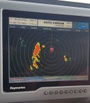
The radar view of bad weather

BTW - see - the boat is on a "Go To Cursor" - with a 7 hr ETA
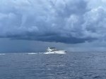
And this is the actual situation - pic taken from another boat

We, quite literally, drove around that storm.
I know this is all "off topic" but maybe it will help keep this thread active until Henry returns.
