Much easier with GPS

boguing

Active member
Joined
5 Nov 2005
Messages
2,227
Location
Styx Marina
Visit site
Don't know if you've seen this before, or if it's even true, but I found this elsewhere on the intarweb:-

New Year 1899-1900

The night was warm and inviting. The stars shone in all their tropical brilliance.
Captain John D Phillips was in a dark corner of the bridge quietly pulling on a cigar with all the contentment that comes to a sailor when he knows the voyage is half complete and they are homeward bound. The passenger steamer SS Warrimoo was quietly knifing her way home through the waters of the mid Pacific, from Vancouver to Australia. The navigator, had just finished working out a star fix and brought the results up to Captain Phillips. The Warrimoo's position was spotted at about Latitude 0* 30' North and Longitude 179* 30' West. The date was December 30th 1899.
First Mate, Daylong broke in "Captain do you realize what this means? We are only a few miles from the intersection of the Equator and the International Date Line". Captain Phillips knew exactly what it meant; he was in good spirits and feeling prankish enough to take full advantage of a unique opportunity to achieve a navigational freak of a lifetime.
In an ordinary crossing of the Date-Line it is confusing enough for passengers because they lose a day, but the possibilities he had before him were sure to confound them for the rest of their lives. He immediately called four more navigators to the bridge and told them to check and double check the ship's position every few minutes and report it to him. He changed course slightly so as to correctly bear on his mark. Then he carefully adjusted the engine speed so he would strike it at the right moment. The clear night, calm sea and the eager co-operation of the entire crew worked successfully in his favour.
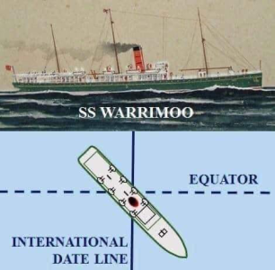
Precisely at Midnight, local time, the Warrimoo, lay on the Equator at exactly the point where it crosses the International Date Line.
The consequences of this bizarre situation were many.
The Forward part of the ship was in the Southern Hemisphere and in the middle of summer.
The Stern was in the Northern Hemisphere and in the middle of Winter.
The date in the after part of the ship was 30th December 1899
Forward it was 1st January 1900.
The ship was not only in two different days, two different years, but two different centuries all at the same time.
Moreover, the passengers had been cheated out of a New Year's Eve celebration. The 31st of December 1899 had disappeared from their lives forever.
Not all was disappointment for the people on board the Warrimoo were the first to greet the new century. All they had to do was run from aft to f'wrd.
Captain Phillips when speaking about it years later said he had never heard of it happening before and the next time the same situation could happen was 1999-2000.
 

Neeves

Well-known member
Joined
20 Nov 2011
Messages
13,186
Location
Sydney, Australia.
Visit site
I was sent this - it is interesting (and has no mention of anchors).


May be an image of submarine, map and text that says SS WARRIMOO EQUATOR INTERNATIONAL DATE LINE

THE GREAT SEA STORY
The passenger steamer SS Warrimoo was quietly knifing its way through the waters of the mid-Pacific on its way from Vancouver to Australia. The navigator had just finished working out a star fix and brought Captain John DS. Phillips, the result. The Warrimoo's position was LAT 0º 31' N and LONG 179 30' W. The date was 31 December 1899.
"Know what this means?"
First Mate Payton broke in, "We're only a few miles from the intersection of the Equator and the International Date Line". Captain Phillips was prankish enough to take full advantage of the opportunity for achieving the navigational freak of a lifetime.
He called his navigators to the bridge to check & double check the ship's position. He changed course slightly so as to bear directly on his mark. Then he adjusted the engine speed. The calm weather & clear night worked in his favour. At mid-night the SS Warrimoo lay on the Equator at exactly the point where it crossed the International Date Line!
The consequences of this bizarre position were many:
The forward part (bow) of the ship was in the Southern Hemisphere & in the middle of summer.
The rear (stern) was in the Northern Hemisphere & in the middle of winter.
The date in the aft part of the ship was 31 December 1899.
In the bow (forward) part it was 1 January 1900.
This ship was therefore not only in:
Two different days,
Two different months,
Two different years,
Two different seasons
But in two different centuries - all at the same time!
 

AntarcticPilot

Well-known member
Joined
4 May 2007
Messages
10,576
Location
Cambridge, UK
www.cooperandyau.co.uk
I was sent this - it is interesting (and has no mention of anchors).
Nice story, but in 1900 (or 1899!) they couldn't have been sure enough of their position to make it true. Even land-based surveyors using theodolites to take star shots can't get their position to better than about 100m-200m, and that's with modern time-keeping. Of course, the Captain could have done it to the best of his ability and then claimed bragging rights, but in fact he couldn't have been that certain of his position. In that era the accuracy of a position at sea was in the region of a nautical mile.

Wikipedia suggests but does not assert that it's an urban legend, and Snopes rates it as "Unproven" (with a big red flag that most of the story dates from 1942!). But in fact, they simply couldn't have known their position to better than the beam of the ship!
 

johnalison

Well-known member
Joined
14 Feb 2007
Messages
40,940
Location
Essex
Visit site
Nice story, but in 1900 (or 1899!) they couldn't have been sure enough of their position to make it true. Even land-based surveyors using theodolites to take star shots can't get their position to better than about 100m-200m, and that's with modern time-keeping. Of course, the Captain could have done it to the best of his ability and then claimed bragging rights, but in fact he couldn't have been that certain of his position. In that era the accuracy of a position at sea was in the region of a nautical mile.

Wikipedia suggests but does not assert that it's an urban legend, and Snopes rates it as "Unproven" (with a big red flag that most of the story dates from 1942!). But in fact, they simply couldn't have known their position to better than the beam of the ship!
I think you are being a bit of a spoilsport! The lines themselves are mostly artificial constructs, making the achievement itself a bit artificial. As they say, it’s the thought that counts.
 

AntarcticPilot

Well-known member
Joined
4 May 2007
Messages
10,576
Location
Cambridge, UK
www.cooperandyau.co.uk
I think you are being a bit of a spoilsport! The lines themselves are mostly artificial constructs, making the achievement itself a bit artificial. As they say, it’s the thought that counts.
Well, maybe. But the equator is not an artificial construct; it is very precisely defined with respect to the axis of rotation of the globe (it is where the plane perpendicular to the axis of rotation and equidistant from either pole intersects the Earth's surface), and cannot be anywhere else. I agree that the location of the 180 degree line is arbitrary and still subject to dispute in 1899/1900 - the French continued to use the Paris meridian until 1911!

Just to REALLY confuse the issue, at present, there are no less than 3 locations (perhaps more - I haven't looked that carefully - where you could do that trip., as the International Date Line does not follow 180° in the vicinity of the equator and because of the various island nations follows a VERY complex path! See International Date Line - Wikipedia
 
Last edited:

johnalison

Well-known member
Joined
14 Feb 2007
Messages
40,940
Location
Essex
Visit site
Well, maybe. But the equator is not an artificial construct; it is very precisely defined with respect to the axis of rotation of the globe (it is where the plane perpendicular to the axis of rotation and equidistant from either pole intersects the Earth's surface), and cannot be anywhere else. I agree that the location of the 180 degree line is arbitrary and still subject to dispute in 1899/1900 - the French continued to use the Paris meridian until 1911!

Just to REALLY confuse the issue, at present, there are no less than 3 locations (perhaps more - I haven't looked that carefully - where you could do that trip., as the International Date Line does not follow 180° in the vicinity of the equator and because of the various island nations follows a VERY complex path! See International Date Line - Wikipedia
Ah. If you want to be precise, even the Equator is arbitrary since the Earth's axis itself is not fixed and moves in a 40+K year cycle and no doubt wobbles a bit, though this may not trouble us greatly during our lifetimes.
 

Frank Holden

Well-known member
Joined
23 Nov 2009
Messages
1,126
Location
Cruising in the Golfo Corcovado
Visit site
I have taken the time to lay of a rhumb line track from Honolulu to Brisbane on OpenCPN. It does indeed pass very close to 0ºLat, 180ºLong and the course is very close to 225º so from the quoted 'evening stars' position that fits, the distance run from stars to midnight is a bit off though.
Strange story of the SS Warimoo

I've also taken the time to find this Shipping. - Arrivals. - The Week (Brisbane, Qld. : 1876 - 1934) - 12 Jan 1900 which has Warrimoo arriving in Brisbane 7th January 1900.
From Lat 0º/Long 180º to Brisbane is about 2250 miles . 7 days is about 13 knots. This is very approximate .
However she would have been in the right place at the right time.

I think the first **known** reference to this incident was in an Ottawa newspaper in 1942 but I can't imagine somebody just dreaming up such a story - with so much historically accurate info - at that time.

Leaving aside all the bits and bobs about navigational accuracy etc etc I reckon that when Capt Phillips went down to breakfast on the 1st of January he would have spun a - reasonably accurate - yarn to the passengers at his table.

If you do a diligent search of 'The Week' for the 12th January , 1900, you may well find it hidden between the Gympie cattle prices and the news from the Transvaal.
 

Neeves

Well-known member
Joined
20 Nov 2011
Messages
13,186
Location
Sydney, Australia.
Visit site
Would you really make it up?

Alternatively if you were of a complex mind and were roughly in the right place at the right time - you would make it up (and then amend the log or course, slightly, to get it right). You and the navigator would sit down over a bottle of whisky and get the details right.

On the assumption the ship was roughly in the right place at the right time - what else are your doing on long passages on a steam ship?

Ships have celebrated crossing the Equator for centuries - no-one has queried the navigational accuracy of the timing - its, if nothing else, something to break the tedium.

To the doubters - lighten up, we need a bit of light relief.

Jonathan
 
Top