Harwich to Ostend - shipping lane question

Captain Crisp

Well-Known Member
Joined
1 Mar 2015
Messages
414
Visit site
Hi,
hoping to make this crossing for the first time in a few weeks time.
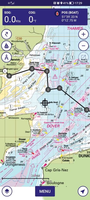
I think I read someone here advising that it's fine to cross the Sunk Centre shipping 'roundabout' ie to go pretty straight from d to F on this image.
Is that right?
Or do I need to follow the recommended route?
Many thanks,
Crisp
 

Attachments

  • Screenshot_20250702_172929_GldypA9e6R.jpeg
    Screenshot_20250702_172929_GldypA9e6R.jpeg
    168.6 KB · Views: 101
I just came though there on Tuesday.
I follow my plotted route ignoring the whole set-up unless there is any shipping using the area.
If there is I alter course to keep out of their way.
It can be challenging to work out where they are planning to exit the roundabout.
I do have AIS on the Plotter which does give a better idea of what they are up to.
 
Leave the Wallet, clear the end of the Gunfleet sands, head for the tip of the Longsand head.(arriving at LW) Once clear steer 127 & let the tide drag you south a bit then east again to your destination. Arrive up tide as tide seems stonger on the Belgian coast. I have rarely seen shipping in the sunk shipping lane to the SE of the Longsand but you can always make allowance in plenty of time if required. But do not do it too late.
When you cross the top of the Black Deep , if you are transmtting on AIS the Sunk control may contact you to ask you to alter course for any shipping transiting the Deep, so keep a radio watch on their VHF channel
 
Suggest you get a copy of Imray’s ‘North Sea Passage Pilot’.
Why waste that money for a single trip? The OP would be far better buying a copy of Reeds almanac which covers a wider area of ports etc &has much more useful info.
Plus , of course, one would expect the OP to have the chart of the southern N sea so he can see where the shipping lanes & wind farms etc are
 
monitor sunk vts as you pass through. They called us up once as a cruise ship was coming through the gyratory and they asked our intentions, advised us of the traffic situation and we agreed how we'd all stay clear of each other. They did not chide us for crossing the roundabout - just v professional and helpful...
 
monitor sunk vts as you pass through. They called us up once as a cruise ship was coming through the gyratory and they asked our intentions, advised us of the traffic situation and we agreed how we'd all stay clear of each other. They did not chide us for crossing the roundabout - just v professional and helpful...
Hello Marmalade - would that be on channel 09? If I don't have AIS, how will they call me?
Thanks,
Crisp
 
Hello Marmalade - would that be on channel 09? If I don't have AIS, how will they call me?
Thanks,
Crisp
They go
"Will the wally in the peaked hat red trousers blue sunstripe on the jib drifting around the shipping lane in a knackered westerly please sod off as you are a danger to yourself as well as the shipping"
You should know if it is you, if your hat blows off before the next call :unsure:
Mind you about 6 other boats within a 5 mile radius will have a squeaky bum moment , but it works, eventually, & they get you by a process of elimination
 
Last edited:
Hello Marmalade - would that be on channel 09? If I don't have AIS, how will they call me?
Thanks,
Crisp
Channel 14. Sunk VTS have radar coverage of the whole area. They'll call you as "the vessel to the south storm of the dynamo buoy" or something like that. With all the ships about and the pilot vessels back and forth through there they'll find a way to get in contact with you. Pilot boats often go pass messages to yachts to contact sunk VTS on 14.
 
Leave the Wallet, clear the end of the Gunfleet sands, head for the tip of the Longsand head.(arriving at LW) Once clear steer 127 & let the tide drag you south a bit then east again to your destination. Arrive up tide as tide seems stonger on the Belgian coast. I have rarely seen shipping in the sunk shipping lane to the SE of the Longsand but you can always make allowance in plenty of time if required. But do not do it too late.
When you cross the top of the Black Deep , if you are transmtting on AIS the Sunk control may contact you to ask you to alter course for any shipping transiting the Deep, so keep a radio watch on their VHF channel
I have heard the advice to arrive at Londsand head at about LW several times, but can someone explain why, and what effect it will have if I am a couple hours after LW? I'm planning a trip to Ostend next Sunday and I'd need to depart at about 3am to get to LS for LW. I'd rather leave at just after 5am!

Also, to save an hour motoring against the tide on the Orwell, has anyone tried anchoring or mooring around Shotley, or even on the Harwich Shelf? I seem to remember there are some swinging moorings just outside Shotely and also near Trinity Pier??
 
From the longsand head the tide carries one south for 6 hours & that is not inconsiderble.
If one averages 6kts SOG- which should be easy over 60 miles with a SW wind in a well found yacht that will take one about 4.5 to 5 miles below ones course.Assuming one has sailed 127 degrees & not followed the chart plotted line
The tide on the southern coast is stronger & travels west east That will leave one with 24 miles to go.
.
As an aside--You should sight the West Hinder pole ( Used to be a lightship) at 5 miles range after you have gone between Twin & Garden city Buoys. These marks used to help re position yourself on line in the pre GPS days. You will also know how far along the course you are by the direction of shipping. Another pre GPS position fix as yu cross the shipping lanes
.
Still doing 6kts SOG & holding 127deg you will be dragged back that .5 miles to your course (plus you will adjust it) as you arrive at ostend
When you sight the West Hinder you should start looking for the tall tower block(Centrum building) at Ostend which on a clear day standing on the deck you might see at 20 miles . Do not aim straight at it or you will end up fighting the tide. Try to keep to the west as the west-east tide gets stronger & takes you to ostend as you cross it diagonally.
If you miss this tide you will get it against you after 2 hours & if you have not taken advantage of the tide from LSH you will be later still so the delay builds up & you will be plugging a strong tide along the belgian coast albeit diagonally. Then it can get rough with wind against tide over the banks. LSH is better tackled with slack steam as the sea can get a bit knarly for 4-5 miles for those unused to it. I normally get seasick here. Rarely fails
A good crossing time is 10 hours I rarely better it & often take 12 hours. So being a little early at LSH may help. But never late because the tides build up against you at the end
Do not worry about the depth over the banks as i have never once run out of water & August will be my 80Th visit to Ostend. f anyone is going to run aground it would be me
I love going in to Ostend at night with all the lights
 
Last edited:
From the longsand head the tide carries one south for 6 hours & that is not inconsiderble.
If one averages 6kts SOG- which should be easy over 60 miles with a SW wind in a well found yacht that will take one about 4.5 to 5 miles below ones course.Assuming one has sailed 127 degrees & not followed the chart plotted line
The tide on the southern coast is stronger & travels west east That will leave one with 24 miles to go.
.
As an aside--You should sight the West Hinder pole ( Used to be a lightship) at 5 miles range after you have gone between Twin & Garden city Buoys. These marks used to help re position yourself on line in the pre GPS days. You will also know how far along the course you are by the direction of shipping. Another pre GPS position fix as yu cross the shipping lanes
.
Still doing 6kts SOG & holding 127deg you will be dragged back that .5 miles to your course (plus you will adjust it) as you arrive at ostend
When you sight the West Hinder you should start looking for the tall tower block(Centrum building) at Ostend which on a clear day standing on the deck you might see at 20 miles . Do not aim straight at it or you will end up fighting the tide. Try to keep to the west as the west-east tide gets stronger & takes you to ostend as you cross it diagonally.
If you miss this tide you will get it against you after 2 hours & if you have not taken advantage of the tide from LSH you will be later still so the delay builds up & you will be plugging a strong tide along the belgian coast albeit diagonally. Then it can get rough with wind against tide over the banks. LSH is better tackled with slack steam as the sea can get a bit knarly for 4-5 miles for those unused to it. I normally get seasick here. Rarely fails
A good crossing time is 10 hours I rarely better it & often take 12 hours. So being a little early at LSH may help. But never late because the tides build up against you at the end
Do not worry about the depth over the banks as i have never once run out of water & August will be my 80Th visit to Ostend. f anyone is going to run aground it would be me
I love going in to Ostend at night with all the lights
Thanks, that is really helpful and detailed. I normally plan on 4 knots average speed, as that is all we can muster under engine. She'll be much quicker under sail, but unlikely to average 6 knots. I brought the chart home, so I'll plot it out and see what the tide does at 4-5 knots. Helpful to know the tide is stronger on the sounthern coast.
 
Thanks, that is really helpful and detailed. I normally plan on 4 knots average speed, as that is all we can muster under engine. She'll be much quicker under sail, but unlikely to average 6 knots. I brought the chart home, so I'll plot it out and see what the tide does at 4-5 knots. Helpful to know the tide is stronger on the sounthern coast.
I did say speed over ground. But you will be on a reach if you are lucky with the wind so you might do better than you think
I forgot to add that leaway will be minimal because with a bit of a swell & a sw wind you will be luffing up quite a bit without realising it & that offsets it
 
From the longsand head the tide carries one south for 6 hours & that is not inconsiderble.
If one averages 6kts SOG- which should be easy over 60 miles with a SW wind in a well found yacht that will take one about 4.5 to 5 miles below ones course.Assuming one has sailed 127 degrees & not followed the chart plotted line
The tide on the southern coast is stronger & travels west east That will leave one with 24 miles to go.
.
As an aside--You should sight the West Hinder pole ( Used to be a lightship) at 5 miles range after you have gone between Twin & Garden city Buoys. These marks used to help re position yourself on line in the pre GPS days. You will also know how far along the course you are by the direction of shipping. Another pre GPS position fix as yu cross the shipping lanes
.
Still doing 6kts SOG & holding 127deg you will be dragged back that .5 miles to your course (plus you will adjust it) as you arrive at ostend
When you sight the West Hinder you should start looking for the tall tower block(Centrum building) at Ostend which on a clear day standing on the deck you might see at 20 miles . Do not aim straight at it or you will end up fighting the tide. Try to keep to the west as the west-east tide gets stronger & takes you to ostend as you cross it diagonally.
If you miss this tide you will get it against you after 2 hours & if you have not taken advantage of the tide from LSH you will be later still so the delay builds up & you will be plugging a strong tide along the belgian coast albeit diagonally. Then it can get rough with wind against tide over the banks. LSH is better tackled with slack steam as the sea can get a bit knarly for 4-5 miles for those unused to it. I normally get seasick here. Rarely fails
A good crossing time is 10 hours I rarely better it & often take 12 hours. So being a little early at LSH may help. But never late because the tides build up against you at the end
Do not worry about the depth over the banks as i have never once run out of water & August will be my 80Th visit to Ostend. f anyone is going to run aground it would be me
I love going in to Ostend at night with all the lights
Thanks for this excellent advice - presumably I do the same in reverse on the way back? 307° and hit LSH at low tide?
 
Just been across and back for a 3 week trip to .NL and passed straight through Sunk precautionary area in both directions. The key thing is to use VHF Ch.14 and AIS if you have it.

On the way out, I was in convoy with another yacht and VTS called them. The other yacht could not actually hear the VTS so I engaged. They wanted to ensure we knew there was a large vessel approaching from the south. I had it on AIS for an hour before and called back saying we knew exactly what the situation was and confirmed our plans to keep clear.

On the way back, I heard various vessels checking in with VTS as they approached the area and made note of their destination so I knew which direction they would be turning. One vessel I was unsure of so preemptively called VTS and they were able to tell me the other vessel was heading to Sunk inner anchorage so I knew to slow down and tweak to stbd before they even started to turn west and I reported that I would do so to the VTS.

The main thing is proactively use VHF 14 as a tool, don't just tune in as a tick-box exercise... Listen to the VTS talking to other vessels, not just you.
VTS are happy for to cut straight across, they just want to know your are alert to what is going on.

AIS was useful, my chart plotter does CPA calculations and I knew an 30min or more before what my passing distance would be in the precautionary area. Also useful in the TSS which seemed empty as I approached it but there were vessels 20NM away doing 20kts and visibility was only 10NM. Calculated CPA predicted I would be 0.5NM off their rear quarter an hour later and it was pretty much spot on.
 
Thanks for this excellent advice - presumably I do the same in reverse on the way back? 307° and hit LSH at low tide?
I would be heading to Bradwell, so I would just look at wind to aim for LW at LSH as I have a window for getting in at the marina Trouble is that I then tend to hit a head wind when I turn , so if I do not get the flood it can be hard work. But rather than fight it at the end of a long holiday & a tiring sail the engine goes on. I can make 6.5kts through the water, more if I want
I have not thought about LSH to Shotley. You may make adjustments for that if still heading N a bit & arrive a little earlier at LSH
But the original question was based on LSH to Ostend
 
Last edited:
I would be heading to Bradwell, so I would just look at wind to aim for LW at LSH as I have a window for getting in at the marina Trouble is that I then tend to hit a head wind when I turn , so if I do not get the flood it can be hard work. But rather than fight it at the end of a long holiday & a tiring sail the engine goes on. I can make 6.5kts through the water, more if I want
I have not thought about LSH to Shotley. You may make adjustments for that if still heading N a bit & arrive a little earlier at LSH
But the original question was based on LSH to Ostend
I'm actually heading to Pyefleet so similar to you, but thought I might overnight at Harwich especially coming back.

But aiming to hit LW at LSH looks sensible both ways.

Many thanks - hoping to set off Monday evening if the current forecast holds.
 
Then you may as well go straight from Pyfleet to save wasting time going to Harwich & have a longer holiday.
The tide out of the Wallet will take you to the LSH quite quick. I tend to allow an extra 10degrees more than I think for the offset from the end of the Gunfleet spit to the end of the long sands as the tide runs across the course there a bit quick, if early, & I always seem to under estimate it.
I watch the depth & cut the sands as tight as I can, by the Black Deep buoy, but always find it disconcerting watching the waves break on the sands.
 
Top