Garmin uhd 95sv - Sonar but no depth reading.

Martin_J

Well-Known Member
Joined
19 Apr 2006
Messages
4,584
Location
Portsmouth, UK
Visit site
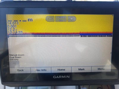
I'm more familiar with B&G or Raymarine but I'm just on a boat that has the above MFD.

It's a new to them boat and the depth seems to just show dashes.

I initially suspected the transducer, but then realised that on the Sonar page, the depth looks to be correct... but still nothing in the depth box at top left.

Were in a marina in just over a metre of water.

Am I missing something in the setup?
 

Attachments

  • 20250517_122110.jpg
    20250517_122110.jpg
    1.4 MB · Views: 6
Last edited:
Don't know if this helps .... I assume you want to have a box overlay on chart screen showing depth ?

Similar to this ?

oYyNGJFl.jpg


It took me a while to get to that ...

My 92sv Manual says :

"Customizing the Data Overlays
You can customize the data in the data overlays shown on a screen.
1
Select an option based on the type of screen you are viewing:

From a full screen view, select Menu > Edit Overlays.

From a combination screen, select Menu > Configure Combination > Edit Overlays.
TIP: To quickly change the data shown in an overlay box, hold the overlay box.
2
Select an item to customize the data and data bar:

To show the data overlays, select Data, select the location, and select Back.

To change the data shown in an overlay box, select the overlay box, select the new data to show, and select Back.

To customize the information shown when navigating, select Navigation, and select an option.

To turn on other data bars, select Top Bar or Bottom Bar, and select the necessary options.
3
Select Done."
 
That's where I also expected to see the depth. We did have the 'Depth' data box showing at the corner of the chart view but it's data just showed '__:_m'

I then ended up going up their mast and fixed the steaming light and then the anchor light.

Back to deck level, I've not searched out the connectivity diagram, but could the sonar transducer only provide a 'sonar' style view and does the MFD rely on a separate depth transducer (e.g. the airmar DST whatever) that appears to not be connected?

I think I need to find the manual...
 
You think you have trouble !! >>>>>>>

KwsN1bkl.jpg


Working from fwd backwards (6 transducers) :

Large black AIRMAR P79S - that feeds the B&G network with depth and temp

Standard Depth Transducer (centreline) that feeds the Garmin .... no idea what Sonar Page would look like as I never use that !

Two 'sonic' transducers - believed to be speed ..... we assume left over from a previous setup and never removed..... each sits under a white metal tab as you see ... we also believe they connect to the strange blue box behind the switch panel allowing auto switching when boat tacks and heels.

Two standard paddle wheel transducers for speed that feed the B&G network .... no idea how they interact when boat heels ....

I had plan to disconnect all - if I could find the other ends of cables ! and then plug each back in one by one - see what fires up !! But never got round to it.
 
Brilliant..

I didn't grab my camera but looked like the sonar transducer was covered with a plastic box... and the Airmar DST8xx was not connected.. but there didn't appear to be any sign of any NMEA2000 connector for it to plug into.. just odd..

One for another day.. When I get time to check the manual, perhaps we'll confirm whether or not the sonar transducer can provide the depth reading for those data boxes on screen.... or whether I need to test the disconnected Airmar... (and find the rest of the backbone!).
It can. Check the data sources, in settings, it might still be set for the redundant DST.
 
It can. Check the data sources, in settings, it might still be set for the redundant DST.
Thank you for this... To be honest, I didn't, in the brief time on board, even find a 'data sources' menu option..

I didn't even see an NMEA 2000 network devices list.

Just wanted to be sure as to what I was chasing up as a possible data source, since the sonar scrolling display (whilst in the marina) looked to be quite accurate..
 
Okay... so there's nothing else on the NMEA2000 backbone I.e. no other sources..

I can look at that...

The question is still about whether or not the 'depth' figure should populate itself from the reading that the sonar shows..

Sonar is directly attached and shows a clear image of the correct depth... but it's not populating either the sonar depth figure.. or the chart depth box .

20250525_132128.jpg
 
With nothing else listed on the NMEA2000 backbone, there was no option to remove a redundant depth source...

I did however pop back to my boat and picked up a few spare depth transducers, after having found the end of their NMEA2000 backbone near the forepeak with nothing plugged into it..

Both of mine showed up on their bus, so I replaced their existing (unconnected) through hull transducer.. Depth now showing fine in the depth data boxes within the chart and within the sonar display.

I'm still intrigued as to whether or not the depth box should have been able to take it's values from the sonar transducer.. It feels like it should have been able to.
I think it should work from the sonar transducer, mine certainly does but my plotters are GPSMap models, not Echomap. Now it's working, is there an option to select the source ? Do you know what model of sonar transducer is fitted ?
 
I will check the model when they're next aboard in the week.. I seem to think the sonar transducer is directly connected to the MFD, if that helps...

Next... They've left... and turned all electrics off... but there is a high pitched squeal/buzz just started from somewhere near the wheel/pedestal...
(This whistle might be another thread!)..
 
I will check the model when they're next aboard in the week.. I seem to think the sonar transducer is directly connected to the MFD, if that helps...
The sonar transducer is on a dedicated connection.
Next... They've left... and turned all electrics off... but there is a high pitched squeal/buzz just started from somewhere near the wheel/pedestal...
(This whistle might be another thread!)..
 
Top