ECMWF vs GFS - over the top gust predictions?

Birdseye

Well-known member
Joined
9 Mar 2003
Messages
28,439
Location
s e wales
Visit site
Agree wholeheartedly with that one. Its a fault of most public published numerical data that rarely if ever are accuracies indicated. Problem is of course that Joe Public usually doesnt know a standard deviation from a sexual deviation
 

GHA

Well-known member
Joined
26 Jun 2013
Messages
12,517
Location
Hopefully somewhere warm
Visit site
I'm not expecting them to be more accurate than any other forecast; I really meant that the way the sites present information in a very precise, finely grained way - almost hour to hour - easily leads the user into expecting a higher degree of accuracy than will ever be the case.
Users maybe, tis the way of the web. Skippers should know better...
 

franksingleton

Well-known member
Joined
27 Oct 2002
Messages
3,666
Location
UK when not sailing
weather.mailasail.com
There is some confusion about the GFS. As from June 2019 it has used a 13 km grid, see https://www.weather.gov/media/notification/scn19-40gfs_v15_1.pdf. They output GRIB data on a 25 km grid. That is consistent with their practice since the earliest GRIB output, ie they issue forecasts at 1/2 the grid use for prediction.

I will come back on some other points after a night’s sleep.
 

franksingleton

Well-known member
Joined
27 Oct 2002
Messages
3,666
Location
UK when not sailing
weather.mailasail.com
NWP model performance depends on grid length, number of levels (vertical grid), depth of the model atmosphere, quality of initial data analysis. WMO has nominated ECMWF to monitor model performance - ECMWF |.

From this, using RMSE of surface pressure;
1. ECMWF, 10km grid, does best. It has more levels (c 130) than other models and runs about 2 1/2 hours later with more data and more time for data analysis.
2. The UK, 10 km grid, 70 levels, comes next With several others just behind.
3. DWD ICON (global), 13 km grid and around 100 levels is slightly better than the GFS, 13 km grid but only 64 levels.
4. Least good are China and Russia. When I last looked, their grids were >15 km.

WMO does not assess the PredictWind “proprietary” model but, as this calculates on a 50 km grid, according to PW, you can draw your own conclusions

I do not know how this information affects wind prediction. Nor how this maps onto the grid on which we get the data. I know that PredictWind provides a free service of ECMWF and GFS data on a 50 km grid. I do not know what resolution they provide to paying customers. One reason that I like XyGrib is that I can see the data at grid points only. Other apps interpolate don’t giving a false ides of resolution. They provide data on the grid used by the various centres for global models.
 

franksingleton

Well-known member
Joined
27 Oct 2002
Messages
3,666
Location
UK when not sailing
weather.mailasail.com
I would like to clarify my assertion that NWP models have to filter out small detail so can only represent weather on a scale of around 5 grid lengths. “Filter” is not quite correct although it is the effect.


NWP calculations have to use smoothing to stop them from developing spurious features; these would occur because of uncertainties in initial analyses. Models also build in a diffusion process to prevent spurious development. In the early days of NWP, models used to become unstable and crash.


For a given grid length (x), the smallest scale that theoretically can be resolved is two grid lengths (2x). But, for these reasons, NWP models are not able to resolve accurately features near the theoretical minimum. The best models can do is to resolve features at slightly larger scales (approximately between 4x and 6x) - this is often referred to as the "effective resolution" of the model.
 
Last edited:

dom

Well-known member
Joined
17 Dec 2003
Messages
7,145
Visit site
I would like to clarify my assertion that NWP models have to filter out small detail so can only represent weather on a scale of around 5 grid lengths. “Filter” is not quite correct although it is the effect.


NWP calculations have to use smoothing to stop them from developing spurious features; these would occur because of uncertainties in initial analyses. Models also build in a diffusion process to prevent spurious development. In the early days of NWP, models used to become unstable and crash.


For a given grid length (x), the smallest scale that theoretically can be resolved is two grid lengths (2x). But, for these reasons, NWP models are not able to resolve accurately features s near the theoretical minimum. The best models can do is to resolve features at slightly larger scales (approximately between 4x and 6x) - this is often referred to as the "effective resolution" of the model.

Really interesting (y)
 

franksingleton

Well-known member
Joined
27 Oct 2002
Messages
3,666
Location
UK when not sailing
weather.mailasail.com
My take on using models.

Using the Windy,com comparison, I can see little consistent pattern in any model being better over the next 5 days. My impression is that they are usually within the model uncertainty factor ie we have a small ensemble that tells you little. Admittedly, I have not done a rigorous analysis. Like everyone else, I am giving subjective impressions based on a small sample. On occasions where one model has differed from the others it has been correct, at others it has not been. Sometimes, one model or another will give stronger average winds. I can see no pattern.

For the reasons at #25, models will invariably tend to underestimate the strongest winds. Because they use slightly longer grid lengths, GFS and ICON global will underestimate slightly more than ECMWF. But the issue is complicated by the resolution at which we see model output compared to that at which models calculate,
 
Last edited:

Laser310

Well-known member
Joined
15 Sep 2014
Messages
1,398
Visit site
There is some confusion about the GFS. As from June 2019 it has used a 13 km grid, see https://www.weather.gov/media/notification/scn19-40gfs_v15_1.pdf. They output GRIB data on a 25 km grid. That is consistent with their practice since the earliest GRIB output, ie they issue forecasts at 1/2 the grid use for prediction.

I will come back on some other points after a night’s sleep.

The full resolution GFS is available as a grib forecast -it's ~0.11deg, or about 12km

it can be downloaded directly within expedition software, or obtained from NOAA

both GFS and EC gust forecasts are usually too high

The NOAA high res models - HRRR for example are beginning to get extremely good - astonishing on some days. The HRRR is run every hour (as opposed to every 6 hrs for most global models) on a 3km grid, with either 1hr or 15 min time steps.., out 18 hours. They also run it at 1km, although i don't think this is operational. The aim is to predict individual convective cells. Although we hear a lot about hurricanes, in the US, economic loss (and human lives lost) due to convective activity is greater than that of hurricanes.
 
Last edited by a moderator:

franksingleton

Well-known member
Joined
27 Oct 2002
Messages
3,666
Location
UK when not sailing
weather.mailasail.com
The full resolution GFS is available as a grib forecast -it's ~0.11deg, or about 12km

it can be downloaded directly within expedition software, or obtained from NOAA

both GFS and EC gust forecasts are usually too high

The NOAA high res models - HRRR for example are beginning to get extremely good - astonishing on some days. The HRRR is run every hour (as opposed to every 6 hrs for most global models) on a 3km grid, with either 1hr or 15 min time steps.., out 18 hours. They also run it at 1km, although i don't think this is operational. The aim is to predict individual convective cells. Although we hear a lot about hurricanes, in the US, economic loss (and human lives lost) due to convective activity is greater than that of hurricanes.
Can you please give me a reference re GRIB output. That is a change from previous practice/policy in the GRIB era. The model certainly runs at 0.11 degree res. They are aiming for 0.1 to come into line with ECMWF and U.K.

As far as I know, gust values are derived from algorithms, ie not strictly a model output. In fact, so are surface (10m) winds. Models levels are terrain following with heights (pressure levels) in the troposphere being percentages of surface pressure. The lowest level is at 0.998 of surface pressure. If surface pressure is 1000 hPa, that is about 15 m agl. They use algorithms based on stability and roughness to get the 10m wind. Upper levels are such as 0.500 x surface pressure, 0.300x, 0.250x etc. Forecasts are still issued for levels at 500, 300, 240 hPa.

I am always sceptical about high resolution models. The lifetimes of small weather features and the noise in the atmosphere set limits to small scale predictability. If you look at the Met Office app you can see significant differences between prediction and reality over short periods over a few hours. Hi res models have their uses. Maybe, had they been use by rail operators, the railway accident in Scotland might have been avoided.
 

Laser310

Well-known member
Joined
15 Sep 2014
Messages
1,398
Visit site
Can you please verify this? I would like to know. If you are correct, I would expect at least on provider to make the data available.

what you can do is download and install expedition - you do not need a license to use the grib downloading and viewing features. It is a pretty good grib viewer and worth having just for that.

you will see the GFS 0.11 as a download option.

it often does not work - but i have gotten it. while the files that come down do open in expedition, i have had difficulty with them in other programs. wgrib does not really like them..., wgrib2 will list the fields, but then says it's a bad file.

the GFS 0.11 direct download in expedition comes via nick's server, and i'm not sure where at noaa he is getting it - i think it's not an "operational" product. you could email him. he's pretty responsive.

because it's on nick's server, you will need to go to the expedition website and make an account with a username and password that you will enter in expedition when you use the grib download from his server - it's free.

i tried uploading a zipped example file here - but it's not allowed. i even tried changing the extension to .png.., but the forum software was wise to that...
 

Roberto

Well-known member
Joined
20 Jul 2001
Messages
5,429
Location
Lorient/Paris
sybrancaleone.blogspot.com
Can you please verify this? I would like to know. If you are correct, I would expect at least on provider to make the data available.

Hello Frank,
GFS 0.12° grid data can be had through a normal saildocs query, then viewed with a grib viewer, here with Xygrib.
Horizontal latitude lines are spaced by a half degree, the grib grid points are visible on the image, there are about 8 to one degree of latitude.
Added image with numerical data
 

Attachments

  • grid.jpg
    grid.jpg
    134.8 KB · Views: 5
  • numdata.jpg
    numdata.jpg
    152.7 KB · Views: 4

franksingleton

Well-known member
Joined
27 Oct 2002
Messages
3,666
Location
UK when not sailing
weather.mailasail.com
Hello Frank,
GFS 0.12° grid data can be had through a normal saildocs query, then viewed with a grib viewer, here with Xygrib.
Horizontal latitude lines are spaced by a half degree, the grib grid points are visible on the image, there are about 8 to one degree of latitude.
Added image with numerical data
Hi, Roberto. I hope you and your family are all well in these troubled times.
I am still at a loss to know where to find the 0.12 degree data. Following links on the Expedition Site, I get to Global Forecast System. Obviously, they compute on the finer grid but output GRIBs on a 0.25 degree grid as they have done since 12 June 2019. How are you accessing the 0.12 degree data? Have you found a way into the inner recesses of the NOAA/NCEP system?
 

Laser310

Well-known member
Joined
15 Sep 2014
Messages
1,398
Visit site
Hi, Roberto. I hope you and your family are all well in these troubled times.
I am still at a loss to know where to find the 0.12 degree data. Following links on the Expedition Site, I get to Global Forecast System. Obviously, they compute on the finer grid but output GRIBs on a 0.25 degree grid as they have done since 12 June 2019. How are you accessing the 0.12 degree data? Have you found a way into the inner recesses of the NOAA/NCEP system?


i wasn't getting it from the expedition website - i was getting the 0.11 within the expedition program..,

but saildocs is easier - just do a normal saildocs email request for GFS.., and substitute 0.11 for 0.25 where you specify the resolution - i think not all the fields that are available from saildocs at 0.25 are available at 0.11..,

expedition has direct download from many sources within the program - draw a box and get the grib. These include, NOAA, Saildocs, Squid, Predict wind, GMN...

Nick (the expedition developer) also has his own server for direct download - he mirrors some models (GFS).., but he is also running hi-res WRF on his server for several popular race regions. 0.11 GFS is available on his server.., and that's what i was doing to get it - because i didn't realize it was also available on saildocs til i learned it in this thread. Saildocs has several undocumented things available. As I mentioned - i was having trouble getting the 0.11 from nicks server.

now i will get it from saildocs - just do that.., it's easy
 

franksingleton

Well-known member
Joined
27 Oct 2002
Messages
3,666
Location
UK when not sailing
weather.mailasail.com
I do find this strange. I sent this message to Saildocs “send gfs:50N,51N,0W,01W/0.12,0.12/0,3,..., 12/“ and got a GRIB file back with data on about a 10 ‘ spacing ie about 16 km. I also sent a request with a 0.1 degree spacing and got the same information. I have to wonder if this is a quirk of the Saildocs system. As I said earlier it is contrary to the long established practice of NOAA only to provide data at half the model res. ie 0.25 degrees.
 

Roberto

Well-known member
Joined
20 Jul 2001
Messages
5,429
Location
Lorient/Paris
sybrancaleone.blogspot.com
This is the type of query I sent to get the data, much like the one indicated above. The numerical table above shows the content of one of the received files data, it shows increments of latitude and longitude of about 7', roughly 0.11-0.12°

send GFS:40N,30N,20W,10W|0.12,0.12|0,72|WIND,MSLP
Your viewer is maybe modifying the display of data?

(Thanks for your thoughts Frank, yes close family fine, my rather old parents both got infected, it lasted ten days "as if a truck went up and down over your body", but eventually -and very fortunately indeed- they both healed. Regards to Mrs Singleton :) )
 

GHA

Well-known member
Joined
26 Jun 2013
Messages
12,517
Location
Hopefully somewhere warm
Visit site
This is the type of query I sent to get the data, much like the one indicated above. The numerical table above shows the content of one of the received files data, it shows increments of latitude and longitude of about 7', roughly 0.11-0.12°
I just downloaded this >
send GFS:48N,47N,20W,19W|0.01,0.01|0,12,24..72|=
WIND,PRESS,APCP,HTSGW,WVPER,WVDIR,GUST

So should be 0.01Deg resolution?

Had to shrink the area otherwise it exceeds the email file size.

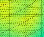
about 0.6Nm spacing in Lat between wind barbs in Opencpn. So doesn't look like the 0.11deg is actual model run data - could be interpolation by saildocs?
 
Top