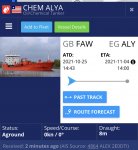
Chemical tanker aground off the Needles.

rotrax

Well-known member
Joined
17 Dec 2010
Messages
15,921
Location
South Oxon and Littlehampton.
Visit site
A fellow Island Packet owner has just sent First Mate an email showing the track of a ship stuck on a rising tide off the Needles.

A chemical tanker, Liberian flag.

Let us hope it gets off without damage or spilling the load. :(
 

dankilb

Well-known member
Joined
23 Jan 2008
Messages
1,536
Visit site
MT seems to put it 1nm or so due West. Quick look at navionics on the phone suggests it should get off most around there at MH with 8m draught. But it’s been decades since I sailed the Solent regularly - there’s the tail of the Shingles and then ‘Dolphin’ showing on the chart (only problems for the big boys, presumably?).
 

onesea

Well-known member
Joined
28 Oct 2011
Messages
3,830
Location
Solent based..
Visit site
Live video feed:

The next question I have seen asked is where’s the tug coming to standby. Guessing by the lifeboat being stood down there is no danger to life no damage.

However she looks like a Chemical carrier so who knows what nasties are onboard
 

Mark-1

Well-known member
Joined
22 Sep 2008
Messages
4,395
Visit site
I guess we don't know why it's aground.

If it's engine failure I suppose they're relying on a tug arriving before the tide drops.

EDIT: Onesea beat me to it.
 

Gary Fox

N/A
Joined
31 Oct 2020
Messages
2,027
Visit site
I wonder if the seabed has moved a bit, maybe in the strong NW winds we had a few days ago, so her charts have become misleading for that spot?
 

Giblets

Well-known member
Joined
5 Mar 2006
Messages
9,254
Location
Surrey
Visit site
Tanker-aground.jpg
 

Bajansailor

Well-known member
Joined
27 Dec 2004
Messages
6,495
Location
Marine Surveyor in Barbados
Visit site
Last edited:

onesea

Well-known member
Joined
28 Oct 2011
Messages
3,830
Location
Solent based..
Visit site
The latest from Marinetraffic mentions that she is aground - yet heading east at 1.9 knots.
CHEM ALYA (Oil/Chemical Tanker) Registered in Liberia - Vessel details, Current position and Voyage information - IMO 9486166, MMSI 636017886, Call Sign D5NE3

Her draught is 8 metres, so fairly well loaded.

It seems a bit strange to me that Marinetraffic is not showing any tugs or other stand-by vessels in the vicinity.

Edit 5 minutes later - she is now doing 5 knots, so hopefully she is free.

1.8 knots could of been current and wind 5 knots surely has to be own power, I guess it takes some time to check the mechanicals after such and event.

AIS, saying Aground could be remembering to push buttons I guess there is allot going on on her at the moment…

Regarding Tugs fully agree at least one should of been there…. The lifeboat was stood down earlier.

Edit to add - I see the Yorkshireman and Scotsman passing Yarmouth as the Chem Aleya is passing Totland bay at 9 knots…. With the patrol boat playing catch up behind,,,
 
Last edited:
Top