Habebty
Well-Known Member
Big tidal range - South Wales?
Could the crane in the background left be on a barge or ship just outside the harbour entrance?If you look at a plan of Dun Laoghaire I don't see which perspective it could be taken from for a pier to obstruct the view of the outer pier as shown in the OP image.
I don't think so. The crane on the left is huge! Compare it with the two on the right...Could the crane in the background left be on a barge or ship just outside the harbour entrance?
“It is a capital mistake to theorize before one has data. Insensibly one begins to twist facts to suit theories, instead of theories to suit facts.” - Sherlock Holmes.

Is that a flight of locks starting just beyond the church?I have an answer to the OP's question...
No!!!!
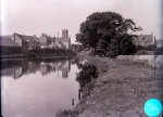
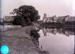
It's a lot of fun, though. Here's one of mine I can't fathom. It'll be Scotland. Taken by my Grandfather ~100 years ago...
It was on a glass photographic plate I backlit and photographed. It may be left/right transposed. I suspect it might be Forth & Clyde canal but it isn't Kirkintilloch.
View attachment 120056
Doubt it. My point was that the pier (here in a muddy orange) is across the harbour, hiding the outer harbour wall, and more of the harbour with ship's masts and cranes beyond it.Could the crane in the background left be on a barge or ship just outside the harbour entrance?
“It is a capital mistake to theorize before one has data. Insensibly one begins to twist facts to suit theories, instead of theories to suit facts.” - Sherlock Holmes.

It might be. It might be the River Cart - my Grandpa lived in Paisley. I sense that the canal/river goes to the right in the distance, but it could be locks. I need to send it to a Paisley historical society and F&C Canal also.Is that a flight of locks starting just beyond the church?
The Cart never had locks. However, the Forth and Cart Canal did - it went from the north shore of the Clyde opposite the mouth of the Cart up to the Forth and Clyde. Absolutely nothing of it left now, but the course is clear, and there is no sign of any church. Mind you, what the Luftwaffe didn't manage to do to Clydebank, local government planning policy did later so it's quite possible that there was a church there once.It might be. It might be the River Cart - my Grandpa lived in Paisley. I sense that the canal/river goes to the right in the distance, but it could be locks. I need to send it to a Paisley historical society and F&C Canal also.
There are some pictures of Tarbert Loch Fyne in the collection but it isn't Crinan Canal.

I didn't know that - thanks. Sorry to drift your thread...The Cart never had locks. However, the Forth and Cart Canal did - it went from the north shore of the Clyde opposite the mouth of the Cart up to the Forth and Clyde. Absolutely nothing of it left now, but the course is clear, and there is no sign of any church. Mind you, what the Luftwaffe didn't manage to do to Clydebank, local government planning policy did later so it's quite possible that there was a church there once.


The NLS maps website is a thing of wonder. Their charges for high quality prints are very reasonable too - I've just taken the Bathymetric Survey of Loch Ken from about 1900 off for framing. They will do prints of old admiralty charts too, some of which are far more detailed than the modern versions.More drift.
Here's an old map showing the spur of canal down to the Clyde, exiting opposite the Cart.
View attachment 120063
The NLS maps are really interesting - you can pick ones of varying age to compare with present day. Rothesay Dock didn't exist towards the end of the 1800s!
Side by side georeferenced maps viewer - Map images - National Library of Scotland
The NLS maps website is a thing of wonder. Their charges for high quality prints are very reasonable too - I've just taken the Bathymetric Survey of Loch Ken from about 1900 off for framing. They will do prints of old admiralty charts too, some of which are far more detailed than the modern versions.
If you enlarge it to +500%, just before it loses definition, the photograph seems to be of a pool; there looks to be no channel or locks in the distance.It might be. It might be the River Cart - my Grandpa lived in Paisley. I sense that the canal/river goes to the right in the distance, but it could be locks. I need to send it to a Paisley historical society and F&C Canal also.
There are some pictures of Tarbert Loch Fyne in the collection but it isn't Crinan Canal.
If you enlarge it to +500%, just before it loses definition, the photograph seems to be of a pool; there looks to be no channel or locks in the distance.
If you enlarge it to +500%, just before it loses definition, the photograph seems to be of a pool; there looks to be no channel or locks in the distance.
I've got a higher resolution version that the forum won't accept for upload, and it looks as if there is weed floating or growing in the water - suggesting it is indeed non-flowing.But the banks don't look as though they are those of a non flowing body of water.

Ah-hah. I wonder if the canal is turning right, out of sight. In which case, how about Boat Green in Gatehouse of Fleet, at the end of the short Fleet Canal? Picture taken from the bottom left of the P for Parking:If you enlarge it to +500%, just before it loses definition, the photograph seems to be of a pool; there looks to be no channel or locks in the distance.


It might be "left-right transposed". Here it is looking radically different! I've looked on Streetview and GoF church tower is different...Ah-hah. I wonder if the canal is turning right, out of sight. In which case, how about Boat Green in Gatehouse of Fleet, at the end of the short Fleet Canal? Picture taken from the bottom left of the P for Parking:

