Burnham Bob
Well-Known Member
I know I'm exposing myself to ridicule but I now have the admiralty leisure portfolio for ramsgate to tower bridge.
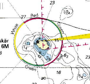
On one, the port of Dover has yellow and red arcs (yellow is marked w for white I presume) around it and on the Gull Stream to Princes Channel chart 5606.4 there is a yellow arc east of North Foreland, a red arc north of Margate and another yellow arc through the Margate Sand.
My admiralty chart symbols book is on the boat and I've never seen these before so I'm stumped. Shell Channel Pilot shows the same arcs around Dover but doesn't explain the significance of red and white sectors and various books I have don't help.
I know its a basic question but help would be appreciated.
")

