Windfarms off Westerschelde new situation

westhinder

Well-Known Member
Joined
15 Feb 2003
Messages
2,663
Location
Belgium
Visit site
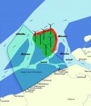
From the first of June, new shipping routes will be in force around the existing and planned Belgian and Dutch windfarms off the mouth of the Westerschelde. The windfarms zone as a whole will be excluded to all traffic, also yachts. In the Dutch part, however, there will be a corridor for small vessels. New shipping routes around the area are established.
I hope this helps:

Windfarms 2.jpg
 

Attachments

  • Windfarms.jpg
    Windfarms.jpg
    56.9 KB · Views: 5
Last edited:
Here is a more detailed view of the new situation.
18011foto.jpg


Note that NHR-S and NHR-SE have moved about 2.5 miles to the South-West from their previous positions. Others may have moved as well.

Here is a brochure (in English) outlining the changes
http://www.varendoejesamen.nl/storage/app/media/downloads/EN_new-shipping-routes-north-sea-coast.pdf

Also note that in the near future, Dutch wind farms will be accessible to small craft (<24m). Certain conditions have to be met, such as (for example):
- They have an active AIS transponder
- Access is allowed only during daylight hours
This was originally planned for April 2017 but has been postponed.
See here: https://www.noordzeeloket.nl/en/news/?item=5288

Enjoy!
 
This is very helpful but I'm finding it difficult to see the most appropriate approach to Westerschelde from the west for a small craft.

I'm planning to visit the area for the first time next month, crossing from Harwich.

Can anyone suggest the best route across the separation zones and avoiding the wind farms? Is it best to keep to the south of the North Hinder junction area?

Steve.
 
Your approach to the Westerschelde will be to the south of the wind farm area - roughly on a line of the Gootebank East Cardinal.

I usually pick up the port hand marks of the deep water shipping channel and follow those in.

Paul.
 
Your approach to the Westerschelde will be to the south of the wind farm area - roughly on a line of the Gootebank East Cardinal.

I usually pick up the port hand marks of the deep water shipping channel and follow those in.

Paul.

Exactly, from the Gootebank, stay North of the deep water route, and cross somewhere along the Scheur or Wielingen, depending on traffic and your destination.
 
Thank you for posting . I find this sort of information very useful and interesting as I am thinking of making a crossing from the UK to the Netherlands next year. Lowestoft to Roompotsuis is presently in my thoughts – therefore probably going North of the traffic separation system .
 
Thanks Westhinder. I see on the chart shown that the narrow EW route actress the North doesn't seem to have any buoys. I don't suppose you know if its marked 'on the ground' as it were?
 
Thanks Westhinder. I see on the chart shown that the narrow EW route actress the North doesn't seem to have any buoys. I don't suppose you know if its marked 'on the ground' as it were?

I haven't passed that way this season, but the Dutch windfarms in that part of the North Sea are only in the planning stage. I would be rather surprised if the area were already buoyed long before any activity takes place there. The same applies for the outermost Belgian windfarms: yet to be built.
 
I haven't passed that way this season, but the Dutch windfarms in that part of the North Sea are only in the planning stage. I would be rather surprised if the area were already buoyed long before any activity takes place there. The same applies for the outermost Belgian windfarms: yet to be built.

Ah. I misunderstood. I thought things were more advanced than they obviously are.
Thanks again

PS I assume the whole area is off limits as of now? We're planning a trip to the Roompot in a week or so
 
Ah. I misunderstood. I thought things were more advanced than they obviously are.
Thanks again

PS I assume the whole area is off limits as of now? We're planning a trip to the Roompot in a week or so

I think I'd aim for the Oosthinder 7 ECM or the Bligh Bank North NCM and from there straight into the Roompot. That will keep you free from the area where construction is taking place
 
Westhinder - can you explain the colour scheme please - ie. the red and green.

Basically the green area is no-go, the red is no-go as well. The only exception will be the narrow corridor in the Dutch part. But to my knowledge it will be some time before they start building in the Dutch part, so there will be no problem there for the time being.
It is a sketch that I borrowed from a press document that was aimed at the general public, and did not conform to any nautical convention. The new situation was explained in that document as 'a roundabout in the North Sea'. Fancy a roundabout with traffic going around in both senses?
That is why I added the nautical chartlet as soon as I found it. Sorry about any confusion.
 
I have just come through the Borssele windfarm area today carefully following the route marked on the Imray chart. I can confirm that there is absolutely nothing there! No construction has started yet although we did see a survey vessel.

Certainly no problem crossing the area at the moment.

Steve
 
Top