Lightwave395
Well-Known Member
Any guidance or tips out there for entering the Vilaine River ? I have a choice between staying where I am or moving to Arzal.
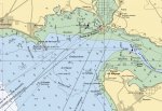
It looks on my Navionics chart viewer that there's virtually no water at low tide East of a line between Pointe de Kervoyal to the North and Pointe de Cofrenau to the South. I'm pondering on moving my boat to Arzal this spring but with a draft of 2.1M wondering in practice how limiting estuary depths might be using Arzal as a base.
It looks on my Navionics chart viewer that there's virtually no water at low tide East of a line between Pointe de Kervoyal to the North and Pointe de Cofrenau to the South. I'm pondering on moving my boat to Arzal this spring but with a draft of 2.1M wondering in practice how limiting estuary depths might be using Arzal as a base.