Urban myths

zoidberg

Well-Known Member
Joined
12 Nov 2016
Messages
6,946
Visit site
"Before getting into fitting-out for heavy weather and preparing for storms before they arrive, let’s debunk a few common myths. First, the notion that with today’s excellent satellite-weather forecasting, you can essentially avoid heavy weather. This sanguine notion is the voice of inexperience."
That's the view from Practical Sailor magazine.

Me, I rely on a lengthy peruse of the clouds above and around - and a thoughtful inspection of my shriveled piece of ould Druid seaweed on a string. Works for me....

You?
 
Weather heavy or light you can't always avoid,
The 3 Rivers Race is always held the weekend after the second May bank holiday, last year's race was in very strong winds.
The winner on handicap did 50 miles straight line distances, much more with tacking, including dropping and raising the mast four times to go under bridges , in under 7 hours.
This year's forecast if correct, I could easily see the same boat taking double that this weekend.

Red sky at night, sailors delight. Red sky in morning, sailors warning", there wasn't much of a red sky this morning, but 40mph gusts are immanent.
 
I'd agree with the quote, for several reasons:
  1. Weather forecasting operates on quite long scales - even the highest resolution models have grid cells several kilometres across, and weather systems less than several grid cells across can be "smoothed out". So the weather forecast can miss local extreme events (e.g. Bayesian).
  2. Again, topographic features that affect wind speed and direction are usually below the resolution of models. Classic examples in the West of Scotland, where the wind can change direction and strength in less than 100m, because of channelling down glens. A pleasant quartering breeze can easily become a hoolie on the nose; been there, done that!
  3. For longer passages, weather forecasting is only reliable for a limited time ahead. At most 7 days, in areas with settled conditions; less than that quite often. The warning given may well be insufficient for a sailing boat to avoid forecast storms.
 
As ever …. It depends.

Yes if you are crossing an ocean then you will be beyond the reliable period for any weather forecast - and need to be prepared for the worst.
And if you are tied to a fixed timetable - eg need to get back on Sunday evening for the office on Monday, then you may be forced to go in bad weather.
BUT if you are coastal cruising and are patient, without fixed destinations or timescales, then you CAN pretty much choose to avoid bad weather. You just may need to wait quite a while in some cases - to get round a tricky headland like Cape Wrath, for example (i believe some waited 3 weeks last year).
When you hit bad weather is when patience runs out and you decide to go with a marginal forecast, rather than delay further.
Not that I would ever do that (pasted by two 40 knot gusts in Kyle Rhea, and plenty of 30 knot squalls in between 10 knot lulls. But it was a classic of keen to move on, knowing the forecast was iffy.)
 
I don't think that I have been caught out by really bad weather since the improved forecasts of the last thirty years have been about. The furthest I have been in open water in this time has been around 24 hours, to Ireland and in the North Sea. The last time I was truly caught out was in the Morning Cloud gale of 1974. On that occasion we had planned to cross the Thames Estuary but the morning forecast was SW 4-5. This would have made the Swin very uncomfortable for our 26'er so we spend the day in the Colne. In the afternoon it blew up to a reefing wind and we had just arrived at Brightlingsea when all hell broke loose, so we dropped sail and went into shelter there, while other boats came in with torn sails and broken masts. Out at sea it would have been very nasty.

In fact, our Irish trip was contrary to the forecast but to a much lesser degree. We left the Scillies with a forecast of light winds becoming SW4-5 which would have been perfect. In the event it blew up to WNW 6 in the night which was very trying for a few hours, but not quite the stuff of legend. Since that time our longer passages have been very much as forecast.
 
I also can't recall the last unforecast storm in my area. I'd be interested in knowing when the last one was.

Clearly if you're crossing oceans you can't avoid bad weather, but that's not.same as it being not being predicted. I'd have thought weekend sailors always know roughly what's coming these days.

I don't recall ever being caught out in completely unexpected heavy weather even before forecasts improved. In contrast I recall twice going out *because* there was a gale. Once to cross the channel in a fantastic following SW gale and once to anchor somewhere I'd always fancied overnight in a gale.

Also, I'm not sure gales are always to be avoided. If you charter you take the weather that comes on the days you gave the boat and wear and tear on the boat is someone else's problem.
 
Once to cross the channel in a fantastic following SW gale and once to anchor somewhere I'd always fancied overnight in a gale.

Also, I'm not sure gales are always to be avoided. If you charter you take the weather that comes on the days you gave the boat and wear and tear on the boat is someone else's problem.
In the days of sailing ships the log would often refer to 'a good gale' as a proper working wind, but a short-handed yacht is a different matter. I'm afraid I've crossed you off my list of people I want to go sailing with. :ROFLMAO:
 
What is the definition of 'heavy weather'? So dependent on other factors eg. boat size, experience, desire etc. Perhaps not necessarily a storm or a gale. For example, for two passage days this week here the forecasts had peak gust of 20kn and 11kn - forecast made on the same day as the passages, but both trips peaked at 29kn. Some might have been caught out by this. The different models often have big differences, so easier to find a forecast after the event which did well, but beforehand you needed second sight to decide which.
 
Got caught out last December on a trip from Eastbourne to Dover.
Forecast was 4-5 with ocassional 6. By the time we got past Dungeness it was blowing an almost constant 7 occasionaly 8.
Getting into Dover was rather interesting.
 
At 0000 hrs just passing Dover as the skipper of the 'ocean going racing dinghy' we were delivering came up with a mug of something hot when the VHF sparked into life and stated gale force 8 imminent on channel 16! We looked at each other and said 'fooook, that was not in the last safety broadcast'; it soon became a dark and stormy night.

An 'interesting' 10 hours followed crossing the Thames Estuary, with gusts of over 50 knots, before we called it a day and ran for shelter in Lowestoft after blowing out an ancient laminated jib - well it had crossed the Atlantic a couple of times and had seen better days.

Clearly somebody in the Met Office had spotted something and was very keen to let everybody know.
 
Got caught out last December on a trip from Eastbourne to Dover.
Forecast was 4-5 with ocassional 6. By the time we got past Dungeness it was blowing an almost constant 7 occasionaly 8.
Getting into Dover was rather interesting.
But which forecast? I always look at multiple.
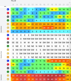
For the next big corner, the forecast for Thursday has GFS (XCWeather) showing Easterly 3kts gusting 5kts, whereas UKMO is showing SW 22 gusting 27kts. If just looked at one could get badly caught out. But comparing GFS, UKHO, ECWF and Spire on Predict winds tells me to not trust the GFS optimism. Will see how resolves tomorrow.
Predictwind was showing all forecasts in roughly the same ballpark, the 6 was the outlier.
 
I disagree with the quote but with the caveat that you’d need to set yourself up for the task. Vagabonde are a good example, they now have a boat fast enough to avoid any weather with a couple of days notice and they’re making it work.
Most of us don’t have a couple of million to drop on a performance trimaran though, or the power to keep Starlink active all day every day.
 
In the days of sailing ships the log would often refer to 'a good gale' as a proper working wind, but a short-handed yacht is a different matter. I'm afraid I've crossed you off my list of people I want to go sailing with. :ROFLMAO:

The X channel was a doddle. Twin brother and I were planning a weekend Solent Cruise together in October. In the event we saw the Forecast, Gentle Nly Friday night, SW gale Sat night Sunday. So we scratched the Solent and went over to Cherbourg Friday night then got up at 5am to come back on the Sunday. When we left it was blowing 55kts at Chi met.

It was a bit daunting setting off knowing that once we left we'd be committed - there would be no going back, but with the smallest foresail and the deepest main reef we flew along surfing all the way. Fantastic, never grinned so much in all my life.

Then there was the time we saw 13.5kts TTW in a Moody 31 surfing on massive waves in a following Gale from Largs to Holy Loch.

I love charter boats. 😁
 
Last edited:
But which forecast? I always look at multiple.
For the next big corner, the forecast for Thursday has GFS (XCWeather) showing Easterly 3kts gusting 5kts, whereas UKMO is showing SW 22 gusting 27kts. If just looked at one could get badly caught out. But comparing GFS, UKHO, ECWF and Spire on Predict winds tells me to not trust the GFS optimism. Will see how resolves tomorrow.
Compare the last three lines, of this Predict Wind summary of forecasts for just 36 hours out … so punk, do you feel lucky!IMG_1721.jpeg
 
Compare the last three lines, of this Predict Wind summary of forecasts for just 36 hours out … so punk, do you feel lucky!View attachment 193936
You’re looking at the problem entirely wrong. If you assume you need to be in a given spot then of course it’s an issue. If you look at weather maps and assume you could travel at 15-20kt for 100-200 miles and avoid the thing 48 hours out then it’s different. For a specific spot there will be disagreement because a weather event might hit or go 20 miles north of that spot. The weather system will be there in all models though at 3 days out.
Extreme weather like a hurricane is a bit bigger but with sufficient speed even those could likely be avoided in most cases.
 
Only been caught out by a previously forecast storm at sea once.
Launched the boat at high tide, in the morning , from South Uist,. Sorted boat, had a little sail, stopped for for lunch.
Listened to the shipping forecast.. gale force 8 immanent.. what? No previous mention of bad weather..
Checked the charts, spent the next 36 hours rocking around in a comparitivly sheltered anchorage.

3 or 4 years ago we had land forecasts for a mildly windy night. That turned out to be a major storm for Norfolk, the MET office didn't name the storm.
Hardly a mention on tv before or after. However it snapped off branches of an oak tree in our garden over a foot in diameter, and caused other damage.. The branches landed on electricity cables so I phoned network suppliers, two days later a crew turned up to sort it.
The crew had come from Ireland!! Crews had had to be brought in from all over the UK such was the damage all over the county...
 
I suppose we need to remind ourselves we're talking about gradient winds. Clearly thermal and wind caused by geographical features are frequently unforecast. (Perhaps always in tbe latter case.)
 
Top