Thames to scheveningen

stu9000

Well-Known Member
Joined
8 Mar 2008
Messages
930
Location
near kingston upon thames, surrey
Visit site
Hi all

I'm planning a trip to scheveningen from the Medway at the end of July.
I have searched ybw and the Web but don't yet have a clear plan in place. I'm here seeking tips and good sources of information. Can anyone recommend a passage planner?

The boat is Westerly 35, I have crew. I plan for a 5k boat speed. I have Ais and have completed a number of night crossings up the East Coast. I have not crossed the Channel for many years.

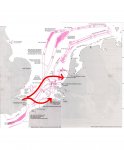
The prevailing wind could be on the nose so I'm working up a dog leg route with a quick stop in Harwich.

The direct route has me crossing a number of shipping lanes obliquely which I'm not to happy about. The Mass Centre Precautionary Area is I'm guessing a bit of a busy roundabout area, best avoided.

I'm in the process of really nailing the plan down so any advice would be welcome.

S
 
The TSS is completely different now from when we did this route regularly but we would head for the south side of the Schelde buoyed channel and cross to a buoy called Fairy. From there northwards it is all relatively shallow water, well buoyed but with no shipping. We usually did this overnight from Scheveningen or Hellevoetsluis, relatively stress free, meeting the shipping lanes at dawn.
 
I don't have a chart to hand but although it makes sense to cross shipping lanes by the shortest route, the strict rules only apply in the separation zones.

I haven't been to Scheveningen for a few years but I seem to recall that the calling channel for the marina is an odd one that we don't use in Britain, so it is easier just to swan in and tie up.
 
I looked on the Navionics web chart and, as suspected, it is very different from 15 - 20 years ago. There is no Fairy buoy now (shame) but the principle remains. Cross the shipping lanes in the middle at the least complex point and get into shallow water near the Schelde entrance, or cross Ramsgate to Dunkerque and take mostly shallow water all the way.
 
That is one way, but his possible alternative of going via Harwich might be better in some circumstances and would be worth planning for.
 
That is one way, but his possible alternative of going via Harwich might be better in some circumstances and would be worth planning for.

Yes, I am no longer familiar with the traffic schemes. In the past there were none north of the Maas until around Texel, so heading north a bit and then straight across was worth doing. Although the schemes do at least confine ships to lanes, whereas north of the Maas they were less predictable.
 
I did the trip Ramsgate-Scheveningen a couple of weeks ago. Because a front was coming up, I first sailed to Blankenberge in Belgium - some 10 hours. After a good night sleep and the passing of the front with some rain I very early took the northgoing tide to Scheveningen. The big advantage is that you take that tide with you: I had the benefit of nearly 10 hours of a favorable current before the tide was turning - and then I was already in Scheveningen (OK, there was 6 to 7 SW blowing, so made a good speed). In this way you avoid the very busy shipping lanes and there are many possibilities of taking refuge (for instance Roompot or Stellendam).
Definitely call the port control in Scheveningen on entry. The marina is in the harbour section in the back, connected by a small channel with the other parts. Fishing Vessels with tourists are passing there and you don't want to meet them in that channel. Port Control will guide you.
The channel is 21, if I remember it correctly.
 
How much time do you have? Are you trying to do this in one go or do you have the time to do a couple of shorter hops?
For one go, I'd leave the Estuary the normal way (Spile and then north of Margate Sand to NE Spit), and then basically straight line it to the TSS. Once you've crossed the main TSS it's then a clear run to Scheveningen, as you should pass south east of the rest of the traffic schemes.
If it's not been said before then this: https://webapp.navionics.com/ is the best passage planning tool I've come across.
I think it's possible to overthink these things, just turn right after Garrison Point, don't hit anything, and you'll be reet.
 
The channel is 21, if I remember it correctly.
Correct.
This site (in Dutch) describes the approach to Scheveningen. Scheveningen Port Control is on channel 21. Scheveningen Yacht Club is on channel 31 (which may or may not be present on your VHF, alternatively you can call them on 06-5329 3137).

Also remember when crossing the very busy Maas Entrance near Rotterdam, you are required to contact Maas Entrance on channel 3 when you're near the MV buoy (coming from the south). Here is more information (in Dutch).

We used to cross the Maas many times per season. Quite incredible how fast these ships can be. A ship on the horizon as we approached would often pass ahead of us before we reached the entrance.
 
I did the trip Ramsgate-Scheveningen a couple of weeks ago. Because a front was coming up, I first sailed to Blankenberge in Belgium - some 10 hours. After a good night sleep and the passing of the front with some rain I very early took the northgoing tide to Scheveningen. The big advantage is that you take that tide with you: I had the benefit of nearly 10 hours of a favorable current before the tide was turning - and then I was already in Scheveningen (OK, there was 6 to 7 SW blowing, so made a good speed). In this way you avoid the very busy shipping lanes and there are many possibilities of taking refuge (for instance Roompot or Stellendam).
Definitely call the port control in Scheveningen on entry. The marina is in the harbour section in the back, connected by a small channel with the other parts. Fishing Vessels with tourists are passing there and you don't want to meet them in that channel. Port Control will guide you.
The channel is 21, if I remember it correctly.

This is extremely helpful. Thank you.
 
How much time do you have? Are you trying to do this in one go or do you have the time to do a couple of shorter hops?
For one go, I'd leave the Estuary the normal way (Spile and then north of Margate Sand to NE Spit), and then basically straight line it to the TSS. Once you've crossed the main TSS it's then a clear run to Scheveningen, as you should pass south east of the rest of the traffic schemes.
If it's not been said before then this: https://webapp.navionics.com/ is the best passage planning tool I've come across.
I think it's possible to overthink these things, just turn right after Garrison Point, don't hit anything, and you'll be reet.

Hi.
I'm looking at this route closely.

If the weather on the day requires it I can break the journey up but part of the purpose of this trip was to experience a longer passage. We're not martyrs though so might well duck into Ramsgate or Blankenberge (which I have yet to visit).

Your route takes us across the east hinder / bligh Bank (nw of veere). That looks a bit hectic to me. Lots of pink arrows converging on that point. Is it not as busy as I'm assuming?

I guess the decision is whether to past North of the Bligh bank 'roundabout' (probably via Harwich) or south (your route).

The southerly route is about 140 nm so a nice 24 hour adventure. It has more stop offs which could be important if conditions are a bit iffy. It fits with the prevailing wind, at least while crossing the Channel. Could be on the nose up the coast I guess. We have to cross the Europort traffic which I have read includes high speed ferries. Do'able though.

I initially thought the northerly route seems longer but I've measured it out at about 140nm which is the same as the southerly route. It has fewer stop off opportunities but passes north of Europort approach traffic. I would have to cross the main north south TSS routes but they are narrow so I'm not too concerned.

The prevailing wind will be the major factor.

I need to look at tidal gates but assuming all things are equal if I left the Medway at noon I would be approaching Dutch coast and europort traffic in the morning.
 

Attachments

  • tss routes.jpg
    tss routes.jpg
    164.9 KB · Views: 3
Top