Tamar River - Navigational & general help needed!

Wandering Star

Well-known member
Joined
8 Feb 2009
Messages
5,280
Location
Dorset
Visit site
I’ve just completed the purchase of a new to me, Dufour 2800 sailboat. It’s ashore with a number of other boats in a farmyard adjacent to the Tamar River in a really isolated spot, We were only able to find the farm using the “3 word” link the broker provided - ///trump.bashful.detriment. I think this places it close to Holes‘s Hole or Weir Quay. The farmer who I haven’t yet met, launches the boats once they’re ready for the water.

Now, the boat needs a polish, Antifoul and the newish Beta 13hp engine will need a service plus I want to fit a couple of through hulls. I plan to have her ready for launch in a couple of weeks. I don’t want to immediately set off before I’ve checked everything’s hunky dory with the boat and its systems. Are there moorings in the river I can use for a couple of nights stay, close to where the boat will be launched (see the “3 words“ location)? Is there a pilot or are there any published notes on sailing (motoring) downriver? I’ve looked at the Navionics chart area and much of the depth is 1 meter or less but I can’t find any info on the tidal range - I need 1.5 meters. Are there any obstructions to motoring down river for example the Navionics chart shows an overhead cable but it doesn’t say what the overhead clearance is. Will it all be easy peasy? Any advice at all welcome as I’m nervous about sailing down a river I’m completely unfamiliar with - once I reach the sea, I’ll be fine!

Be very grateful for any local knowledge & advice - Thanks.
 

Wandering Star

Well-known member
Joined
8 Feb 2009
Messages
5,280
Location
Dorset
Visit site
Ah, useful, thanks very much - sounds just what I need. I did Google but didn’t come across their website so feeling a bit calmer now!
 

LittleSister

Well-known member
Joined
12 Nov 2007
Messages
18,716
Location
Me Norfolk/Suffolk border - Boat Deben & Southwold
Visit site
It's very easy. The main thing to watch out for from Weir Quay down to Plymouth/Devonport is the shallows around where the Tavy joins the Tamar. You'll need a bit of tide to get you past that. Immediately upstream of Weir Quay on the bends its deep, but further up it soon gets shallow at low tide (more or less dries a little south of Calstock), but plenty of water to get quite deep boats up there at high tide.

Heading through Weir Quay just keep between the central lines of moorings (with the largest boats). Downstream after that follow the buoyage, but it's all a bit approximate in the aforementioned area where the Tavy joins the Tamar. You'll need chart, sounder and a bit of following your nose.

Once you're past there it's very straightforward and well buoyed. Keep an eye out for any navy ships or workboats manoeuvring, and for the big buoys they have alongside the main channel in places.

You must give way to the Torpoint ferries. There's an exclusion zone around the Navy ships moored, berthed or moving, but I don't know what it is now. (They've got much more nervous about that than was the practice when I berthed down there years ago at Weir Quay and upriver at Calstock.)
Mayflower Marina is on your left shortly before you reach open water. (Might be a handy place to stay so you get a good start when you head off out to sea to wherever).

Beyond that the main big ship channel wraps round the north side of Drakes Island, but small craft can pass to the west of the island. Be cautious here. There are lots of nasties between the Island and the Cornish shore, with a narrow well marked pass 'The Bridge' between them. Do not pass outside of the marks for this, and beware the tide through here can be very strong.

Once you're through that you have lots of space, but watch out for ships, subs etc., that don't - the big ones will be following the deep water channel.
 
Last edited:

cagey

Well-known member
Joined
6 May 2004
Messages
2,241
Location
Cornwall
Visit site
Hi, not my home waters but I spent a while at Saltash SC so I have a passing knowledge of the area. I would choose your leaving time with care the tides all the way out to the Sound can be interesting, I would leave on an ebb tide no point pushing against a strong tide, there is nothing of particular danger as long as you stay in Nav channel no overhead cables to worry about. Journey becomes interesting from Brunels rail bridge. Watch out for MOD police they are friendly but they have an important job to do, can’t remember the exclusion distance from dockyard but will be easy to find, be aware of chain ferries, be careful of strong tides at dog leg of Cremyll and Narrows. If you decide to use The Bridge don’t take any shortcuts if you left Weir at HW then you will be loosing water, alternatively stay N of Drakes Island. From here it’s about an hour to breakwater, if you decide to stay in Marina ,be aware they’re all expensive and have unpleasant tides.
Hopefully someone with better knowledge than me will help. Best of luck I’ve only mentioned the bad points ,It is an amazing place, enjoy.
K
 

LittleSister

Well-known member
Joined
12 Nov 2007
Messages
18,716
Location
Me Norfolk/Suffolk border - Boat Deben & Southwold
Visit site
A nice place to visit while you're doing your fettling and shakedown is Dandy Hole, up the St. Germans or Lynher River, off the Tamar south of Saltash. You'll need a rise of tide to get in (and out of) there, but at Dandy Hole there's a deep, er, hole which is a marked anchorage and a lovely place to overnight.

I can recommend getting hold of a copy of West Country Cruising. p.s. Gulp! I've just seen it's now £35, and called West Country Cruising Companion. But you could buy an old one for about a £5 and it would still be very useful, treated with a degree of scepticism about facilities and services - the nav will be pretty much unchanged.
 
Last edited:

Sandy

Well-known member
Joined
31 Aug 2011
Messages
21,897
Location
On the Celtic Fringe
duckduckgo.com
Download the Plymouth Anchorages Guide

Listen on VHF Ch14 for Fleet and Longroom the VTS. Grey Funnel Line (Royal Navy) have right of way. Submarines are escorted by people in black who will politely ask you to move, dodging the Tamar ferry is a bit like playing chicken. You will be very welcome at all the sailing clubs.

To add what @doug748 has said Imray do Plymouth Harbour and Rivers C14, well worth having in the chart table.
 

Wandering Star

Well-known member
Joined
8 Feb 2009
Messages
5,280
Location
Dorset
Visit site
Just invested (?) in a latest (9th) edition of West Country Cruising!

Doug748 - thanks for this, I haven’t made contact with the farm owner yet, I plan to spend 3 days working on the boat next week and will ensure I chat to him then. I didn’t know I had to wait for a bunch of boats to be launched together so that’s useful info too. Thanks.
 

Capt Popeye

Well-known member
Joined
30 Sep 2011
Messages
18,830
Location
Dawlish South Devon
Visit site
Might mention that Weir Quay Boatyard has services that oe might like /care to make use of whilst there /passing

Its a working Boat yard , Chandlery plus a Cafe on certain days , plus pontoon to access them
 

doug748

Well-known member
Joined
1 Oct 2002
Messages
13,350
Location
UK. South West.
Visit site
Just invested (?) in a latest (9th) edition of West Country Cruising!

Doug748 - thanks for this, I haven’t made contact with the farm owner yet, I plan to spend 3 days working on the boat next week and will ensure I chat to him then. I didn’t know I had to wait for a bunch of boats to be launched together so that’s useful info too. Thanks.

A good book it may be all you need.

I think he likes to line up a few launches where he can - up there the tides are the thing. Good luck with your new boat.
 

KeithMD

Well-known member
Joined
21 Feb 2023
Messages
596
Visit site
It's very easy. The main thing to watch out for from Weir Quay down to Plymouth/Devonport is the shallows around where the Tavy joins the Tamar. You'll need a bit of tide to get you past that.

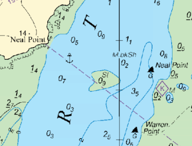
@Wandering Star - just as @LittleSister says, and watch out for the "lump" in the main channel at Neal Point.
Some muppets (cough, blush) have been known to run aground on that.
"Not for navigation"

1681054703737.png
 

CliveF

Active member
Joined
15 Jan 2017
Messages
135
Visit site
if you right click on an item in the navionics chart it will bring up a cross hair , then click on the ? to get more info.

hopefully that will show you the clearance available.
 
Top