You are using an out of date browser. It may not display this or other websites correctly.
You should upgrade or use an alternative browser.
You should upgrade or use an alternative browser.
Storm Floris
- Thread starter Thistle
- Start date
johnalison
Well-Known Member
Frank Singleton sits in his little cubby-hole and fiddles with his slide rule until he gets the numbers he wants and then announces doom and gloom to the rest of us.
franksingleton
Well-Known Member
That might have been so when I first joined the Met Office. By the early 1970s it had all changed. Try reading Behind the Forecast - Franks-Weather - The Weather Window.Frank Singleton sits in his little cubby-hole and fiddles with his slide rule until he gets the numbers he wants and then announces doom and gloom to the rest of us.
Birdseye
Well-Known Member
long since learned that the best way of forecasting the weather is to assume that tomorrow is the same as today. Wont be right all the time but that isnt the issue. The issue is whether its nearer right than the met office and the answer to that is yes.
the weather at our local weather station is near enough exactly what it was 24 hours ago - 22kngusting 31 compared to 24kn gusting 32
the weather at our local weather station is near enough exactly what it was 24 hours ago - 22kngusting 31 compared to 24kn gusting 32
Baddox
Well-Known Member
That would go badly for us.long since learned that the best way of forecasting the weather is to assume that tomorrow is the same as today. Wont be right all the time but that isnt the issue. The issue is whether its nearer right than the met office and the answer to that is yes.
the weather at our local weather station is near enough exactly what it was 24 hours ago - 22kngusting 31 compared to 24kn gusting 32
Yesterday we had very calm sunny weather that gave time to prepare for today's gales.
Last edited:
dombuckley
Well-Known Member
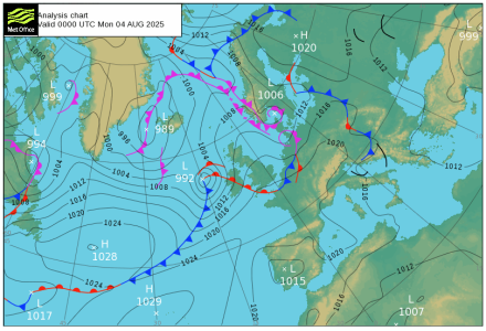
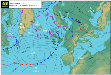
That may be true for your location in Wales, but not in the area affected by the storm. Stornoway was SW 9kts gusting 13 yesterday morning; this morning it was SSE 32kts gusting 43. As for barometric pressure, John O'Groats recorded 977mb at mid-day today, so the MetOffice was pretty much spot on with the forecast.long since learned that the best way of forecasting the weather is to assume that tomorrow is the same as today. Wont be right all the time but that isnt the issue. The issue is whether its nearer right than the met office and the answer to that is yes.
the weather at our local weather station is near enough exactly what it was 24 hours ago - 22kngusting 31 compared to 24kn gusting 32
Porthandbuoy
Well-Known Member
Holed up in Troon marina. Just seen a 45 knot gust, storm force 9 FFS. Sheolin tugging at her doubled up warps.
franksingleton
Well-Known Member
Provide statistical confirmation.long since learned that the best way of forecasting the weather is to assume that tomorrow is the same as today. Wont be right all the time but that isnt the issue. The issue is whether its nearer right than the met office and the answer to that is yes.
the weather at our local weather station is near enough exactly what it was 24 hours ago - 22kngusting 31 compared to 24kn gusting 32
Chiara’s slave
Well-Known Member
As opposed to confirmation bias, indeed. Conversation about our changeable weather is a part of the fabric of society. It’s different every day, is it not?Provide statistical confirmation.
franksingleton
Well-Known Member
The nonsense about persistence forecasts was kicked into touch longer ago than I can remember. And that is a long time ago.As opposed to confirmation bias, indeed. Conversation about our changeable weather is a part of the fabric of society. It’s different every day, is it not?
Thistle
Well-Known Member
So a bit shy of a couple of hundred iterations of calculations based on a set of initial values. Sounds like huge scope for compounding any errors (even just rounding errors) in those initial values. I'd guess there must be a bit more to it.That might have been so when I first joined the Met Office. By the early 1970s it had all changed. Try reading Behind the Forecast - Franks-Weather - The Weather Window.
Chiara’s slave
Well-Known Member
Before I was born possibly. We are our club’s weather nuts. I’ve just had some practice in looking at the forecasts, and remembering what that’ll mean locally. The last bit is quite easy, it’s working out what the weather will do more than a day or 2 ahead that seems to be challenging. And whilst it seems as if we get a F5 south westerly to blow over every spring ebb, I think that’s just the law of sod in action. Anyway, tomorrow’s weather will be nothing like todays. Which tends to reinforce your point.The nonsense about persistence forecasts was kicked into touch longer ago than I can remember. And that is a long time ago.
William_H
Well-Known Member
Speaking of weather (32S). Last Saturday bureau forecast a front arriving and it did. A dilly. The temperature during the night was reasonably warm for winter due to warm North east winds. Such that the maximum temperature for the day occurred at 6AM before sun rise. 15 degrees. Then the cold front arrived wind swung around to south and cold set in with rain. Very odd. But typical that we et nicer weather just before a storm. I love looking at the rain radar to see rain coming. ol'will
franksingleton
Well-Known Member
You are clearly blissfully unaware of the research that has gone into model development dating back to the first electronic computers, the development of satellite sensing back to the 1970s, the R&D into use of these many and varied data. But, yes there is always scope for a glitch in the data or model formulation. One of the benefits of having models run by major weather services. Just occasionally, one will differ from the rest. The similarity between models even out to 5 or more days is encouraging. So is the ability to give days warnings of severe events even though the detail will never be perfect/So a bit shy of a couple of hundred iterations of calculations based on a set of initial values. Sounds like huge scope for compounding any errors (even just rounding errors) in those initial values. I'd guess there must be a bit more to it.
Last edited:
Thistle
Well-Known Member
Hence my question!You are clearly blissfully unaware of the research that has gone into model development dating back to the first electronic computers, the development of satellite sensing back to the 1970s, the R&D into use of these many and varied data.
franksingleton
Well-Known Member
I read your post as a statement which is how it is phrased.Hence my question!
Other threads that may be of interest
- Replies
- 335
- Views
- 7K


