Saint Malo. Navionics show rocks on approach channel

slipknot

Well-Known Member
Joined
28 Nov 2003
Messages
548
Location
South Coast
Visit site
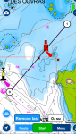
Considering using well established route into St Malo. Route 4 or 5 in Reeds and other pilot books. All looks pretty straightforward. Just looked at this on navionics and it shows a rock which ‘covers and uncovers’ exactly on the prescribed route near the port channel marker close to le petit bey. Can’t see this on any other chart, plotter, pilot book. Anyone have any detailed knowledge of this. Is navionics correct? Have I missed something?
 

Attachments

  • 2A8A5272-C4FD-4394-BBC3-2582B35B4CC5.png
    2A8A5272-C4FD-4394-BBC3-2582B35B4CC5.png
    331 KB · Views: 0
I can't comment on the exact positioning - I've never been into St. Malo in anything smaller than a car ferry - but there certainly are rocks around the points marked on Navionics.
 
If I’ve correctly identified the area you mean, then yes, the Admiralty chart shows a rock there:

FDtp4oth.jpg


The pencil crosses, incidentally, mark which rocks near my route could be ignored due to the rise of tide last time I went in there. That rock is only 1.4m above datum in an area with 12m tides, so you will most likely be able to ignore it too.

Pete
 
Thanks for the reply. The rock identified on my navionics photo is on the track south west of les crapards du bey. The one marked by your pencil is off the track. Your chart shows what I see on everything else I look at, no rock where navionics show one.
 
Ah, I see - when you said “rock which covers and uncovers” I thought you meant the green drying contour southeast of the buoy (which the paper chart indicates as rocky by the “craggy” shape of the line).

Seems you actually meant the red-and-black symbol vaguely resembling an explosion - must admit my eye slid right over that as it looked more like a Navionics icon of some kind rather than a chart symbol.

I suspect it’s not real.

Pete
 
Navionics says it a rock that ‘covers & uncovers’....... The question really is about the navionics providing different info to everything else. I’ll avoid just in case ��
 
Is it there or isn’t it there????
Charts say it isn’t. Shouldn’t be dependent on what charts you are using.

It does depend on the chart you are using, or at least the reliability of the data being shown does. It is likely that the Navionics chart doesn't meet the quality controls required for a proper electronic navigation system. The Hydrographic Office explains a bit about ithttps://www.admiralty.co.uk/news/blogs/s-57-and-the-latest-iho-standards

​​​​​​​​​​​​​​​​​​​​​S-57, S-63 and S-52 are some of the important ECDIS and ENC Standards that have been developed by the International Hydrographic Organization (IHO) to support Safety of Life At Sea (SOLAS). Met by all charts in the ADMIRALTY Vector Chart Service​, these standards have been put into place to ensure that all Electronic Navigational Charts (ENCs) are accurate, secure and can be interpreted correctly by type-approved Electronic Chart Display and Information Systems (ECDIS).
 
Let’s not forget that Navionics have form - with an imaginary canal through the oyster beds at St Vaast, non-existent rocks in an East Coast creek, and one or two fantasy sandbanks in the Solent to name just the ones I remember showing up on these forums.

Pete
 
Until I knew otherwise, I would work on the assumption that there might be a rock there and keep away from where it is supposed to be.

Mind you, last time I was there I had no Navionics app (no tablet even!) and would have blithely sailed across where the rock is supposed to lie. :D
 
this is the latest official chart, no such rock.
Navionics sometimes insert new features as "cooperative soundings as checked by our team of hydrographers", never ever seen any of their hydrographers check anything on the field, not even sunbathing on the beach :p and on second check about 99.9% of these discoveries are plain false.

stmalo.jpg
 
Top