Concerto
Well-Known Member
Oh what a grey and boring day.
The weather forecast was looking good last night to get to an ultimate place, so after checking the tide tables, I needed to set the alarm for 4am. Checking the weather again this morning, it was forecast as cyclonic 3 to 5 becoming SW 4 to 6 later, so still good for the trip. Whilst I prepared myself and Concerto, I left the curtains closed as it was raining lightly. Once I did look outside I could not believe it was quite misty. Fingers crossed the sun should soon burn that off. Slipped the berth in Vidlin at 4.45, the fastest I had done it so far on this trip.
Visibility was about mile, so not that bad and I trust the chart plotter for accuracy, otherwise I would not have moved in years gone by. Well after nearly 11 hours of motoring I am now in Burra Voe marina on Yell, only 9 miles from where I started from. So, what happened?
As I headed northward, the tide was with me, but there was almost no wind. The forward motion was sufficient to get a little drive from the mainsail, so it was hoisted. After about 10 miles, the visibility dropped to about 200 metres. As I passed to the west side of Fetlar the gap between a small island was under a mile, but as I was midway between them I could see neither. As I entered Bluemull Sound, between Yell and Unst, the distance is narrow at ½ a mile at one point. I could just see the land on both sides. Then looking astern I saw a local ferry passing to starboard.
Passing further into Bluemull Sound, the visibility improved to over a mile but the tide was against me as it is a pinch point and flowing at 2½ knots. So I headed close to shore but trying to stay close to a rocky shoreline is not fun, I tried to stay with 6 to 8 metres under the keel, but once it dropped to 4 metres, so turned away from the shore. Gradually I passed through the sound and visibilty to the west was good, but ahead it looked foggy. Changing from the Yell side to the Unst shore took a while, but was it very rough and jagged with rocks, but the fog had dropped to under 100 metres. To start, the tide weakened and after about ½ mile was with me again. Trying to keep close to the shore to cheat the tides was difficult due to the ragged nature of this shore, so as the tide changed direction I moved away from the shore for a bit more safety.
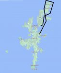
The further north I went, the fog got thicker. Not what I wanted, I wanted to see the shore. Near the top, I closed to about 75 metres from the shore and I could make out the shape of the cliffs and waves crashing on the rocks, but no detail. The lighthouse was not seen. I headed the couple of hundred metres further north to Out Stack. Making it out in the gloom, I suddenly realised there were some waves breaking over some rocks ahead, so a quick course change meant I passed these by about 25 metres, luckily I managed to video this. Then the water became quite turbulent and as I turned eastward and the water smoothed out, there were lots of gannets sitting in the water and a solitary puffin. For those of you who did not know it, Out Stack, is the most northerly point of Britain and the lighthouse is Muckle Flugga. All that effort to get there and nothing to really see, what a disappointment.
Passing along the top of Unst, the turbulence started again close to Holm of Skaw. Still motoring. the waves were almost square to the bow and quite steep. Climbing the wave mean the descent could drop the bow down. I did manage to shoot some good video of this, but missed when the bow ploughed down and water flooded over the foredeck and crashed on the coachroof as far back as the mast. Luckily this turbulence only lasted about 5 minutes before I turned southward.
Originally I had planned to go to the marina in Balta Sound, but I would be there by 13.00. I could get the bike out to visit the nearby Unst Boat Haven in Harold's Wick with its display of Shetland boats, but after checking the local weather I decided I might as well continue on to Burra Voe and be there by 15.30. However the weather had a final twist, the visibilty improved as it started to rain. Luckily it did not worry me as I had been in full oil skins all day to keep the damp away and to stay warm. Having phoned the marina, the manager was on the pontoon to take my lines as they were fitted with them hoops. I was prepared with my line reaver this time, but assistance is always better.
Tomorrow I am going to the Old Haa museum that is nearby. Hopefully the forecast is as wrong as today. Today the wind never appeared over force 2. Tomorrow there is a 25% chance of rain showers almost all day, so hoping they get that wrong.
Today has been no fun looking at a wall of grey for almost the whole day, knowing one of the sights of my trip was invisible and I used a lot of diesel to see nothing. I was so bored I ended up getting the Shetland Bus book out in the cockpit and I have now finished it.
For those wanting the final trip details, I motored for 10¾ hours and the distance was about 63 miles giving an average speed over the ground of 5.8 knots, which was close to the 5.5 knots the log was showing. The strong adverse tide in Bluemull Sound was the killer of a better overall speed as I had tide with me for almost the whole trip.
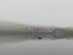
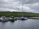
Leaving Vidlin. No other photos are worth showing.
The weather forecast was looking good last night to get to an ultimate place, so after checking the tide tables, I needed to set the alarm for 4am. Checking the weather again this morning, it was forecast as cyclonic 3 to 5 becoming SW 4 to 6 later, so still good for the trip. Whilst I prepared myself and Concerto, I left the curtains closed as it was raining lightly. Once I did look outside I could not believe it was quite misty. Fingers crossed the sun should soon burn that off. Slipped the berth in Vidlin at 4.45, the fastest I had done it so far on this trip.
Visibility was about mile, so not that bad and I trust the chart plotter for accuracy, otherwise I would not have moved in years gone by. Well after nearly 11 hours of motoring I am now in Burra Voe marina on Yell, only 9 miles from where I started from. So, what happened?
As I headed northward, the tide was with me, but there was almost no wind. The forward motion was sufficient to get a little drive from the mainsail, so it was hoisted. After about 10 miles, the visibility dropped to about 200 metres. As I passed to the west side of Fetlar the gap between a small island was under a mile, but as I was midway between them I could see neither. As I entered Bluemull Sound, between Yell and Unst, the distance is narrow at ½ a mile at one point. I could just see the land on both sides. Then looking astern I saw a local ferry passing to starboard.
Passing further into Bluemull Sound, the visibility improved to over a mile but the tide was against me as it is a pinch point and flowing at 2½ knots. So I headed close to shore but trying to stay close to a rocky shoreline is not fun, I tried to stay with 6 to 8 metres under the keel, but once it dropped to 4 metres, so turned away from the shore. Gradually I passed through the sound and visibilty to the west was good, but ahead it looked foggy. Changing from the Yell side to the Unst shore took a while, but was it very rough and jagged with rocks, but the fog had dropped to under 100 metres. To start, the tide weakened and after about ½ mile was with me again. Trying to keep close to the shore to cheat the tides was difficult due to the ragged nature of this shore, so as the tide changed direction I moved away from the shore for a bit more safety.
The further north I went, the fog got thicker. Not what I wanted, I wanted to see the shore. Near the top, I closed to about 75 metres from the shore and I could make out the shape of the cliffs and waves crashing on the rocks, but no detail. The lighthouse was not seen. I headed the couple of hundred metres further north to Out Stack. Making it out in the gloom, I suddenly realised there were some waves breaking over some rocks ahead, so a quick course change meant I passed these by about 25 metres, luckily I managed to video this. Then the water became quite turbulent and as I turned eastward and the water smoothed out, there were lots of gannets sitting in the water and a solitary puffin. For those of you who did not know it, Out Stack, is the most northerly point of Britain and the lighthouse is Muckle Flugga. All that effort to get there and nothing to really see, what a disappointment.
Passing along the top of Unst, the turbulence started again close to Holm of Skaw. Still motoring. the waves were almost square to the bow and quite steep. Climbing the wave mean the descent could drop the bow down. I did manage to shoot some good video of this, but missed when the bow ploughed down and water flooded over the foredeck and crashed on the coachroof as far back as the mast. Luckily this turbulence only lasted about 5 minutes before I turned southward.
Originally I had planned to go to the marina in Balta Sound, but I would be there by 13.00. I could get the bike out to visit the nearby Unst Boat Haven in Harold's Wick with its display of Shetland boats, but after checking the local weather I decided I might as well continue on to Burra Voe and be there by 15.30. However the weather had a final twist, the visibilty improved as it started to rain. Luckily it did not worry me as I had been in full oil skins all day to keep the damp away and to stay warm. Having phoned the marina, the manager was on the pontoon to take my lines as they were fitted with them hoops. I was prepared with my line reaver this time, but assistance is always better.
Tomorrow I am going to the Old Haa museum that is nearby. Hopefully the forecast is as wrong as today. Today the wind never appeared over force 2. Tomorrow there is a 25% chance of rain showers almost all day, so hoping they get that wrong.
Today has been no fun looking at a wall of grey for almost the whole day, knowing one of the sights of my trip was invisible and I used a lot of diesel to see nothing. I was so bored I ended up getting the Shetland Bus book out in the cockpit and I have now finished it.
For those wanting the final trip details, I motored for 10¾ hours and the distance was about 63 miles giving an average speed over the ground of 5.8 knots, which was close to the 5.5 knots the log was showing. The strong adverse tide in Bluemull Sound was the killer of a better overall speed as I had tide with me for almost the whole trip.

Leaving Vidlin. No other photos are worth showing.


