Picture location?

sgr143

Well-Known Member
Joined
26 Jul 2016
Messages
493
Location
Oxford & WicorMarine
Visit site
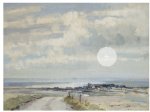
Might anyone, possibly Norfolk or Suffolk based, be able to help with identifying where this picture is of? (It's from my College: the white blob is to enlarge the picture if you are on the page in the link below.)

More information at: A Coastal Mystery | St Edmund Hall
 

Attachments

  • Image4.jpg
    Image4.jpg
    67.5 KB · Views: 150
Last edited:
Perhaps I phrased my original post badly. We know the painting is by Seago. it's the original painting, not a copy. But we don't know what location it's a depiction of. There's nothing on the back of it to help. It might have helped if whoever in St Edmund Hall who bought it asked, "Now then, Eddie,, nice painting, looks lovely on our wall; where's it of then?" but they didn't; or if they did, nobody thought to write it down. So it won't be information that can be found on the web.

What I'm asking is if anyone recognises the setting from real life! Or memory thereof, given the current situation...

Thanks -

Steve
 
The church is very like St Mary;s Brancaster?

Thanks! But I think the tower is too high to fit with what's in the painting - it's a feature that Jonathan Yates points out on the St Edmund Hall blog post. I'll ask him for a list of "places considered but rejected", and put them on here to avoid duplication of effort. I've been right round the coast myself on Google maps and not found anything, but it's easy to miss something that local knowledge might unearth.
 
I believe it could well be Morston church. The view of Blakeney Harbour across Morston Salt Marshes and sails in the distance would all fit in. The second chancel also ties up, as does the orientation. The Norfolk Churches website has a good pic of the church. The OS Explorer Map 251 Norfolk Coast Central shows a track called Binham Lane, which could be where this scene was painted from. None of the other local churches has the double chancel and several are ruled out because they have round towers.
 
I believe it could well be Morston church. The view of Blakeney Harbour across Morston Salt Marshes and sails in the distance would all fit in. The second chancel also ties up, as does the orientation. The Norfolk Churches website has a good pic of the church. The OS Explorer Map 251 Norfolk Coast Central shows a track called Binham Lane, which could be where this scene was painted from. None of the other local churches has the double chancel and several are ruled out because they have round towers.
Morston church lies east-west with the tower at the west end. There's a very good shadow on Google maps that shows that. Binham Lane is west of the church, so it would be looking at the wrong end. Somewhere up Holt Lane would be looking at the church from a better angle, 45 degrees approx to the church's axis, which seems about right with the picture, or maybe up Kettle Hill, perhaps at the corner of the unnamed track that bends to the right just to the east. That would give a bit of elevation to look down at the village. On Google maps satellite view there's a clump of trees to the north of the church which corresponds to the picture. On streetview you can't go up Holt Lane, but you can see its start which looks about right. It's even got the strip down the middle.
 
Last edited:
Yes, Kettle Hill and Holt Lane have you looking at least in the right direction. And there's not too many places in East Anglia where you can see water to the WNW.

Pity we can't get a more close up view of the church - the tower on Morston Church is pig ugly and it should be recognisable even after the most artistic portrayal.
 
Thank you, Jan, Angus and Motor! I think you have it. The various 360 degree views around the church on google street view do show something very like. The finial (if that's the word) on the E end of the main chancel seem to have taken a knock since the picture was painted, and Seago has been kind to the definitely "pig-ugly" tower. I don't have that OS map on paper, but this resource is very useful:
Explore georeferenced maps - Map images - National Library of Scotland
The viewpoint of Kettle hill seems very possible, though maybe the course of the road / track shown on the painting doesn't quite tally. The background of salt-flats and distant land to the N looks right.
Anyway, I'll pass all this on to my colleague at the College.
Steve
 
Last edited:
I believe it could well be Morston church. The view of Blakeney Harbour across Morston Salt Marshes and sails in the distance would all fit in. The second chancel also ties up, as does the orientation. The Norfolk Churches website has a good pic of the church. The OS Explorer Map 251 Norfolk Coast Central shows a track called Binham Lane, which could be where this scene was painted from. None of the other local churches has the double chancel and several are ruled out because they have round towers.

Good shout.
 
Thank you, Jan, Angus and Motor! I think you have it. The various 360 degree views around the church on google street view do show something very like. The finial (if that's the word) on the E end of the main chancel seem to have taken a knock since the picture was painted, and Seago has been kind to the definitely "pig-ugly" tower. I don't have that OS map on paper, but this resource is very useful:
Explore georeferenced maps - Map images - National Library of Scotland
The viewpoint of Kettle hill seems very possible, though maybe the course of the road / track shown on the painting doesn't quite tally. The background of salt-flats and distant land to the N looks right.
Anyway, I'll pass all this on to my colleague at the College.
Steve

Holt Lane has changed slightly and some trees have appeared on the latest maps...

Location Map.
 
From Jonathan Yates ( St Edmund Hall), who sends thanks to you all for your help:

"I just had a quick look at the OS satellite images - and it seems quite likely. I’d previously been round north Norfolk on google maps - but hadn’t spotted this angle.

It was puzzling because it felt like North Norfolk (when I was an u/grad I used to take the train from Cambridge to Kings Lynn, and then cycle up to the coast there to birdwatch). But I was confused by the angle of the church to the coast - but what is proposed solves this part of it. As a final check, I might see if there is a local vicar listed and see what they think.

I now have somewhere to visit when travel becomes possible.

I think it will probably go out in the college newsletter today - so I’ll give it to mid next week before I post an update to the blog. "
 
Yes, having had another look at the map, the viewpoint cannot have been from Binham Lane. Holt Lane or possibly Kettle Hill, which is on higher ground, are much more likely. The once bendy local tracks have almost certainly been straightened since Seago's day.
We used to go walking up there years ago. It would be lovely to return one day, when we are freed, to see if we can locate the exact spot.
 
Top