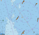
Navionics AIS

Sgeir

Well-known member
Joined
22 Nov 2004
Messages
14,791
Location
Stirling
s14.photobucket.com
I worked in an industry that went metric about 50 years ago. The most significant aspect of the change was that we had to extend our stride by three and a bit inches.

When I took up sailing relatively late in life many more experienced sailors measured in fathoms, yards, cables, and, of course, NMs. For my part, I tend to use metres for height, depth and short horizontal distances, but cables and NMs for greater distances.

Depending on scale, most coastal charts show minutes of latitude divided into tenths, ie cables. So, to me, it seems entirely logical to use cables when appropriate, but I'm really quite comfortable with either cables or metres.
 

requiem

Active member
Joined
20 Mar 2019
Messages
254
Visit site
BCPA (Bearing of Closest Point of Approach) would tell you this, but from memory that's missing from the Navionics app. I remember thinking exactly this, that knowing that closest point of approach will be 300m in 6 minutes is not as useful if you don't know if you'll be passing in front or behind. (And does CPA take into account the length of the ship?)

The safe assumption would be that the CPA calculations do not factor in the size or orientation of the vessels. A proper AIS configuration will include the vessel's dimensions and the placement of the GPS antenna relative to them, and thus the app I use claims to calculate CPA based on the center point of the vessels. Calculating swept path makes things a bit more complicated. The other number to keep an eye out for is BCR (bow crossing range), which should be self-explanatory; negative values indicate passing astern.

In this screenshot, the black dots indicate the GPS antenna location (for reference, the center ship is about 348 m long):
ais-antenna-placement.png

Got a simple question - if I put Open CPN on a Mac laptop, can I input all the data (GPS, AIS etc) to it via wifi (presumably as some kind of NMEA format) ? Or does it need some cables?

If you can do wifi, it should be able to display it. About the only caveat to bear in mind is that Raymarine's wifi doesn't include a NMEA data stream; for that you might need a separate device. I have no problem getting my phone/tablet/etc. to talk to other wifi-enabled systems, e.g. B&G.
 
Last edited:

alexincornwall

Active member
Joined
20 Mar 2017
Messages
246
Visit site
Navionics only allows you to set a target vector length on a time based projection between 0-30 minutes. You cannot define the vector to show the position at the TCPA (or the BCR at @requiem suggests). I think the only way that could be done would be to wait until the TCPA is under 30 minutes and then change the vector length but that would be very fiddly as it would require going back to the settings menu for every target.

IMG_3327.PNG

The Vesper Watchman app allows a target to be selected and the vector set for the TCPA so in the screen shot below, we are the green line and it is clear that Triton will pass our stern. Ignore the other targets, they were in our convoy. Not a great example but the only one I have.

IMG_3332.PNG
 

requiem

Active member
Joined
20 Mar 2019
Messages
254
Visit site
I think the only way that could be done would be to wait until the TCPA is under 30 minutes and then change the vector length but that would be very fiddly as it would require going back to the settings menu for every target.

So long as the vector lengths exceed the TCPA you can simply compare where they cross. Setting the length to your "I don't worry about targets more then X minutes out" threshold helps. If they cross at similar positions, e.g. at the midpoint of both vectors, worry. It needn't be exact, because if you can't eyeball it then the CPA is probably too close for comfort.

For example, if Pride maintained her course (she didn't) she would pass ahead of Côte d'Opale (first half of her vector crosses second half of Côte's). The tanker will pass astern.

1644941546820.png
 

Yealm

Well-known member
Joined
13 Apr 2017
Messages
5,340
Visit site
Navionics only allows you to set a target vector length on a time based projection between 0-30 minutes. You cannot define the vector to show the position at the TCPA (or the BCR at @requiem suggests). I think the only way that could be done would be to wait until the TCPA is under 30 minutes and then change the vector length but that would be very fiddly as it would require going back to the settings menu for every target.

View attachment 130452

The Vesper Watchman app allows a target to be selected and the vector set for the TCPA so in the screen shot below, we are the green line and it is clear that Triton will pass our stern. Ignore the other targets, they were in our convoy. Not a great example but the only one I have.

View attachment 130453
On the Vespa screen the blue and green blobs represent respective boat positions at CPA?
Looks lovely and simple..
Wonder why Navionics didn't do this - the maths must be easy peasy
 
Last edited:

CPD

Well-known member
Joined
20 Sep 2006
Messages
3,010
Location
Hampshire
Visit site
Interesting how people use AIS differently, expectations etc. All I want is for it to give me (relative to me) approximate distance, direction of travel, and possibly speed, although you can normally guess that. I will do the rest.

Using the clever bits of maths, especcially the bits which would indicate safe to cross in front ............ seems very stressfull. If you are that close or unsure, then why not go behind ??
 

requiem

Active member
Joined
20 Mar 2019
Messages
254
Visit site
Using the clever bits of maths, especcially the bits which would indicate safe to cross in front ............ seems very stressfull. If you are that close or unsure, then why not go behind ??

In a busy traffic area, going behind it doesn't mean you aren't simply going in front of someone else.

But, in my experience the checks are more a way to validate that what I think is safe is indeed safe. Humans tend to be bad at estimating time/speed/distance once the numbers get large, which is why Rule 7(c) is there.
 
Top