Bathbuoy
Member
Can I ask a basic navigation question about using a plotter, in this case the Savvy Navvy app.
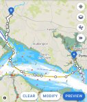
Attached is our route from Gosport Marina to Swanwick Marina at high tide 1300 on 16th April. Our draft is 2.5m but even at high tide (4.5m) the route takes us the long way round the deep water channel rather than cutting through North of the bramble bank.
With a 4.5m tide would just staying out of the green drying areas not give us enough water? It seems an excessively long route for us at high tide.
Thanks