identifying Laylines

TallBuoy

Member
Joined
19 Aug 2015
Messages
245
Location
Lymington
Visit site
I've just been catching up on the thread about one or several tacks which refers to lay lines for obvious reasons.

If one of the crew has time and skill to work them out from wind angles and tide at the time, fine.

But I am often skippering with a crew of inexperienced clients, having to stay behind the wheel and near the mainsheet at all times, so navigational decisions are 'on the fly'. I often can't set up a waypoint on the GPS.

What are the hot tops for keeping it simple and effective ?
 

flaming

Well-known member
Joined
24 Mar 2004
Messages
15,117
Visit site
Gauge the tacking angle of your boat. When you're practising try and judge where the heading will end up from your normal position. I.e. From where I'm normally sat is there a stantion that is approx where my heading will be after the tack?

Then if tide under you tack a bit early, if tide against you, tack a bit late. That's all I used to do when doing the majority of Corporate stuff. The exception was Cowes week, when I used to detail one of the clients "tactician" and give them my handheld GPS and get them to call BTW and CMG out when I asked for it. That worked brilliantly, and the brighter ones soon worked out why and started giving opinions as to if we'd gone far enough, which I used to encourage by getting them to remember the CMG on each tack and compare to the BTW.
 

john_morris_uk

Well-known member
Joined
3 Jul 2002
Messages
27,310
Location
At sea somewhere.
yachtserendipity.wordpress.com
Gauge the tacking angle of your boat. When you're practising try and judge where the heading will end up from your normal position. I.e. From where I'm normally sat is there a stantion that is approx where my heading will be after the tack?

Then if tide under you tack a bit early, if tide against you, tack a bit late. That's all I used to do when doing the majority of Corporate stuff. The exception was Cowes week, when I used to detail one of the clients "tactician" and give them my handheld GPS and get them to call BTW and CMG out when I asked for it. That worked brilliantly, and the brighter ones soon worked out why and started giving opinions as to if we'd gone far enough, which I used to encourage by getting them to remember the CMG on each tack and compare to the BTW.

That system works quite well. I used to enter every mark into the GPS as as a way point before Cowes week. It took several minutes....! We would then sail to several marks to check accuracy.
 

flaming

Well-known member
Joined
24 Mar 2004
Messages
15,117
Visit site
That system works quite well. I used to enter every mark into the GPS as as a way point before Cowes week. It took several minutes....! We would then sail to several marks to check accuracy.

Several minutes!!? It takes absolutely ages! Though if you have a newfangled GPS that you can connect to a computer there are several places where you can download the marks, including the Cowes week website normally.
 

bbg

Active member
Joined
2 May 2005
Messages
6,780
Visit site
I used to race on a J-24 with tacking angles marked on the deck in permanent marker. About three angles, as I recall, perhaps 5 degrees apart at around 90 degrees. Trimmer / tactician would get into the cockpit and eye up the angles. Different tacking angles for light wind, normal and heavy air.

Then, as you say, add or remove a little (or use one of the tacking angles) based on tide under you or against you. And the biggest issue in a big fleet is having someone tack in front of you when you are on the lay line. So if you are not leading the fleet, you may need to overspend (possibly by several boat lengths) to make sure you don't get buried.
 

john_morris_uk

Well-known member
Joined
3 Jul 2002
Messages
27,310
Location
At sea somewhere.
yachtserendipity.wordpress.com
Several minutes!!? It takes absolutely ages! Though if you have a newfangled GPS that you can connect to a computer there are several places where you can download the marks, including the Cowes week website normally.

I should have added a smiley instead of just the '...!' as I was joking (or being economic with the truth). You're right - it took AGES. And then we used to go through them all again to check them. Hours more like...
 

RobbieW

Well-known member
Joined
24 Jun 2007
Messages
4,658
Location
On land for now
Visit site
Several minutes!!? It takes absolutely ages! Though if you have a newfangled GPS that you can connect to a computer there are several places where you can download the marks, including the Cowes week website normally.

You must have a VERY old GPS :) Even my Garmin 72 has a serial connection (fortunately so does my laptop) which, combined with GPSU, I've used for doing that sort of thing for > 10 years
 

lw395

Well-known member
Joined
16 May 2007
Messages
41,951
Visit site
I've just been catching up on the thread about one or several tacks which refers to lay lines for obvious reasons.

If one of the crew has time and skill to work them out from wind angles and tide at the time, fine.

But I am often skippering with a crew of inexperienced clients, having to stay behind the wheel and near the mainsheet at all times, so navigational decisions are 'on the fly'. I often can't set up a waypoint on the GPS.

What are the hot tops for keeping it simple and effective ?
If you're sailing out of Lymington, you'll find most of the marks are in more or less tide than the rest of the leg, so playing with the GPS will only get you so close.
The most important thing is to know what the tide is doing.
Then it's mostly judgement.
In a fleet race, worry more about your position relative to the rest of the boats than finding the layline from miles off.
It does pay to have some sighting lines on the boat.
 

Keen_Ed

Active member
Joined
13 Dec 2002
Messages
1,818
Visit site
I used to race on a J-24 with tacking angles marked on the deck in permanent marker. About three angles, as I recall, perhaps 5 degrees apart at around 90 degrees. Trimmer / tactician would get into the cockpit and eye up the angles. Different tacking angles for light wind, normal and heavy air

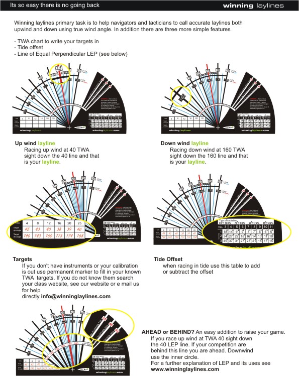
Available from winning tides.

WL%20help%20document%20C.jpg
 

Birdseye

Well-known member
Joined
9 Mar 2003
Messages
28,142
Location
s e wales
Visit site
I guess that most of us end up doing just what Flaming describes. I have a B&G plotter that would do it for me and no doubt more accurately but that requires all the kit to talk to each other so it doesnt yet work.
 

lw395

Well-known member
Joined
16 May 2007
Messages
41,951
Visit site
I guess that most of us end up doing just what Flaming describes. I have a B&G plotter that would do it for me and no doubt more accurately but that requires all the kit to talk to each other so it doesnt yet work.
People who sail dinghies and other simple boats get pretty good at it without any of the electronic crutches.

Hence SirBen being a bit useful in the AC.
 

flaming

Well-known member
Joined
24 Mar 2004
Messages
15,117
Visit site
I guess that most of us end up doing just what Flaming describes. I have a B&G plotter that would do it for me and no doubt more accurately but that requires all the kit to talk to each other so it doesnt yet work.

I got the idea that the OP was sailing charter boats, so couldn't really put the layline marks on the deck. If you can though, Keen Ed's lines are great for calling that final tack into the mark. If you're trying to nail a layline from a long way off (classic Cowes example of beating up the shore, judging the moment to commit to the long tack out into the tide for the mark in the deep water) then some sort of electronic assistance is handy.
 

garvellachs

Member
Joined
23 Mar 2002
Messages
913
Location
Dorset
Visit site
I'm not sure what the devices do, but I had a think about this after racing 10 days ago in light air. I sail upwind with the apparent wind dial on about 35 or 40 deg. But I tack when the mark is roughly just aft of the beam. On a gps our track shows, in light air, that we tack maybe 120 deg (the boat is old with a wide sheeting angle). The thing is, the boat's movement drives the wind forward, depending on the ratio of the real wind speed to the real boat speed. When it's breezy, the boat speed is smaller relative to the wind speed so the effect is less? But when the wind is light, the boat speed to wind speed ratio is, I think, higher, so the tacking angle increases? Does that match others' experience?
 

lw395

Well-known member
Joined
16 May 2007
Messages
41,951
Visit site
I'm not sure what the devices do, but I had a think about this after racing 10 days ago in light air. I sail upwind with the apparent wind dial on about 35 or 40 deg. But I tack when the mark is roughly just aft of the beam. On a gps our track shows, in light air, that we tack maybe 120 deg (the boat is old with a wide sheeting angle). The thing is, the boat's movement drives the wind forward, depending on the ratio of the real wind speed to the real boat speed. When it's breezy, the boat speed is smaller relative to the wind speed so the effect is less? But when the wind is light, the boat speed to wind speed ratio is, I think, higher, so the tacking angle increases? Does that match others' experience?
Up to a point.
Light airs generally mean flatter water so the boat will point a bit higher on the apparent wind.
And lighter breezes often shift more, so you tack through smaller angles on the shifts.....
 

lw395

Well-known member
Joined
16 May 2007
Messages
41,951
Visit site
I got the idea that the OP was sailing charter boats, so couldn't really put the layline marks on the deck. If you can though, Keen Ed's lines are great for calling that final tack into the mark. If you're trying to nail a layline from a long way off (classic Cowes example of beating up the shore, judging the moment to commit to the long tack out into the tide for the mark in the deep water) then some sort of electronic assistance is handy.

Carrying someone who's done their time in X-boats or Dragons or similar works well too.
The electronics might be cheaper to run though....
 
Top