Goodwin Sands

Capt Popeye

Well-known member
Joined
30 Sep 2011
Messages
18,799
Location
Dawlish South Devon
Visit site
all our boats at our club sink into the soft mud/ sand each tide nearly to the water line and each tide all float, this is over 100 boats each tide and all keel types, never seen one with any issue. All move about and rock away quite happily. There must be something else going on as I’m sure the reports cannot all be wrong
Hi there Mr D I am not meaning to be silly, but suggestthat your Club boats cannot be described as 'sink' into the soft mud, more like 'settle' into the soft mud ?

Its a bit like describing a Boat thats afloat as'sinking' because its 'taking on water' ; a boat thats 'taking on water' is just either leaking or its rain water, surely ?
 

Leighb

Well-known member
Joined
8 Aug 2007
Messages
6,762
Location
Suffolk
Visit site
Having just checked the chart on my iPad, it’s not quite as “hole shaped“ as I thought, but still a deeper anomaly in a relatively flat area. See below - “The Well” near Armada mark.

View attachment 103654
I have had a further look around the area, and notice that there are 3 or 4 other "holes" of similar depth near the Cork Ledge racing mark, NW of Cork Sand. You might think that tidal movement of sand and mud would fill these in but obviously not.
 

steve yates

Well-known member
Joined
16 Oct 2014
Messages
3,795
Location
Benfleet, Essex/Keswick, Cumbria
Visit site
Why have I never read cautionary tales about such dangers from Maurice Griffiths, Des Sleightholme, Charlie Stock and others from an earlier era when drying out on sandbanks was more common? Those writers did, by contrast, highlight the deadly dangers of being bashed on the sands by waves, the boat filling if a deep keeled boat were laid too far over, the wind rising or changing direction, being holed by debris or one's own anchor fluke, or getting neaped.

I am open to persuasion that there is some sort of danger to intact yachts from quicksand, but I've seen no evidence yet.

Probably as you mentioned, gales and storm weather, nowt to do with quicksand of the like. No one lands and dries out on a sandbank in a gale among breaking waves, therefore there is no action which puts them in a position to be buried in sand.

We all know how snowdrifts form, and we've all seen sand on a beach pile up along a groyne or similar before.

So surely it's a logical step to assume that a large vessel pinned on a sand bank, amid high waves and violent wave action, will act as a breakwater and allow the tons of sand being thrown around to quickly pile up against it, and quite foreseeabley cover most of it up. They probably reappear when there is a gale or from a different direction, and the sand is being dragged and blown away from the submerged boat.
 

Hallberg-Rassy

Active member
Joined
29 Oct 2020
Messages
246
Visit site
So surely it's a logical step to assume that a large vessel pinned on a sand bank, amid high waves and violent wave action, will act as a breakwater and allow the tons of sand being thrown around to quickly pile up against it, and quite foreseeabley cover most of it up.
But that would require the sandbank to be built up 10', 20' above HIGH tide to hide them. It doesn't happen, does it?

The other big difference is that groynes, let alone dry land, are all rooted on solid foundations, not a 100' of sand-water mix before solid chalk bedrock is felt.
 

Capt Popeye

Well-known member
Joined
30 Sep 2011
Messages
18,799
Location
Dawlish South Devon
Visit site
But that would require the sandbank to be built up 10', 20' above HIGH tide to hide them. It doesn't happen, does it?

The other big difference is that groynes, let alone dry land, are all rooted on solid foundations, not a 100' of sand-water mix before solid chalk bedrock is felt.
Hi would suggest that instead of the Sand being built up, it actually is swallowed up into a hole or void that appears or is formed inside the natural crafted sand the craft is overwhelmed by the sand filling the craft up as it sinks into the void so with the result that the craft is overwhelmed by the influx of wet sand and its sucked downwards beneath thenatural sand line or height ?

Some time later on, the reverse happens and the Craft is uplifted to the natural height of the sand but cannot float owing to being filled up with the sand ? perhaps
 

steve yates

Well-known member
Joined
16 Oct 2014
Messages
3,795
Location
Benfleet, Essex/Keswick, Cumbria
Visit site
But that would require the sandbank to be built up 10', 20' above HIGH tide to hide them. It doesn't happen, does it?

The other big difference is that groynes, let alone dry land, are all rooted on solid foundations, not a 100' of sand-water mix before solid chalk bedrock is felt.
Damn, good point. Hadn't thought that through :)

Sooo, perhaps its the action of the retreating breaking wavesthat scour sand away from underneath the structure only to dump it back alongside it, and eventually over it as the wave action continues?
 

jimi

Well-known member
Joined
19 Dec 2001
Messages
28,663
Location
St Neots
Visit site
Damn, good point. Hadn't thought that through :)

Sooo, perhaps its the action of the retreating breaking wavesthat scour sand away from underneath the structure only to dump it back alongside it, and eventually over it as the wave action continues?
If you put a brick on a Sandy beach what happens to it?
 

tillergirl

Well-known member
Joined
5 Nov 2002
Messages
8,366
Location
West Mersea
Visit site
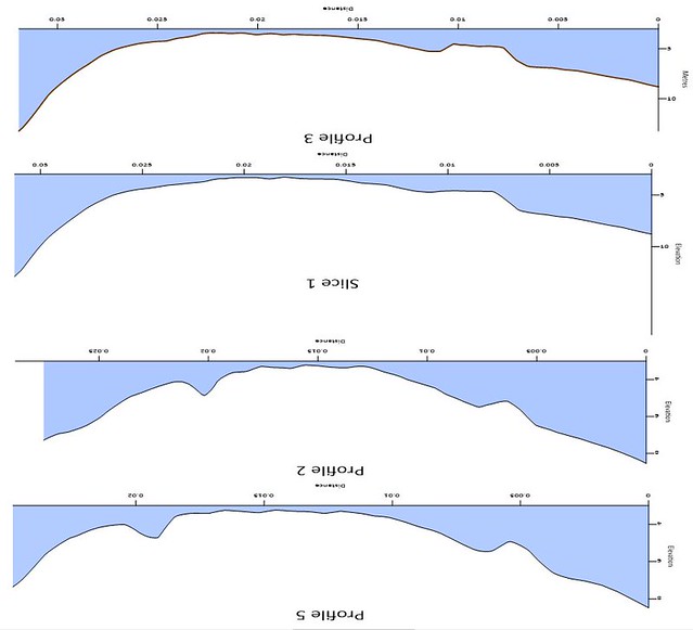
An example of scour I think:

Image18 by Roger Gaspar, on Flickr

That is a series of 'slices' progressively across the Little Sunk. The 'V' on the bottom two slices to the left is an old wreck marked on charts. The ratio height x width isn't to scale so the 'V' should be much flatter - but nevertheless there.
 

Leighb

Well-known member
Joined
8 Aug 2007
Messages
6,762
Location
Suffolk
Visit site
An example of scour I think:

Image18 by Roger Gaspar, on Flickr

That is a series of 'slices' progressively across the Little Sunk. The 'V' on the bottom two slices to the left is an old wreck marked on charts. The ratio height x width isn't to scale so the 'V' should be much flatter - but nevertheless there.
Is it possible to repost the right way up?
 

tillergirl

Well-known member
Joined
5 Nov 2002
Messages
8,366
Location
West Mersea
Visit site
Well....... yes and no. The profile is the right way up. Words? No. Well not quickly. I was practicing 'cutting the slices' ages ago and just recorded that quickly. I would have to reload all the data again from scratch so it would take 15 minutes. And SWMBO is cracking her whip.
 

Hallberg-Rassy

Active member
Joined
29 Oct 2020
Messages
246
Visit site
Is it possible to repost the right way up?

I thought that was an underwater profile of the Sands and thought it was quite accurate.

Bricks? not sure of the point being made.

If it's Crosby Beach, not a lot. They've been there since WWII.

ApwDpH4mJlm96LTKemr7oiG42d_eahFCuEMYYOXqGFOj0dMUUyDHqVJYwU_KId-wM5jl55D65qPbk9JMa0rJZf6JVojxlCrm6MHMcHXdsHnzv9XCNLhl7CNe2O-FuO2Ei8oE3IB4MKCO6Ish
 

Tomahawk

Well-known member
Joined
5 Sep 2010
Messages
19,151
Location
Where life is good
Visit site
Which is what? 70 years? In geological time it doesn't even figure on super slow motion..\But look carefully and those bricks are disappearing fast. In another 50 years that bit of wall woill be half that size.
 

Hallberg-Rassy

Active member
Joined
29 Oct 2020
Messages
246
Visit site
The sinking boats and sands don't fall into geology though. I think they call it geomorphology?

In all fairness, I think this was more what the poster above was thinking about. I don't think it's a good comparison though, because what we're talking about is when the entire Sands change into a morphing slurry among relatively powerful tides and flows, and ships disappear in a single tide or two.

There are, however, some sandy beaches that have disappeared overnight, and then reappeared perhaps years later.

Chris_2Stones_2.jpg
 

ex-Gladys

Well-known member
Joined
29 Aug 2003
Messages
5,190
Location
Colchester, Essex
Visit site
The sinking boats and sands don't fall into geology though. I think they call it geomorphology?

In all fairness, I think this was more what the poster above was thinking about. I don't think it's a good comparison though, because what we're talking about is when the entire Sands change into a morphing slurry among relatively powerful tides and flows, and ships disappear in a single tide or two.

There are, however, some sandy beaches that have disappeared overnight, and then reappeared perhaps years later.
There's a cove between Porthcurno and Land's End called Nanjizal, and that will be boulders one year and sand the next...
 

tillergirl

Well-known member
Joined
5 Nov 2002
Messages
8,366
Location
West Mersea
Visit site
Just flipped it in photoshop
Why? You turned it the wrong way up! It's the profile of the Sunk Sand! Black Deep to the left, Barrow Deep to the right. I thought the blue water was the clue. The profile is the right way up, it's just the words are upside. I can explain why but I was just trying to illustrate the scouring of a wreck and nothing else.
 
Top