14K478
Well-Known Member
E-Loran
If this has been covered already I apologise.
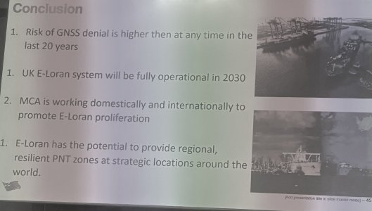
I was at a presentation by the UK Maritime and Coastguard Agency (“MCA”) in London last Thursday and there was a short presentation on their plan to instal an E-Loran system covering the British Isles, to be operational in 2030.
This is because of the increased risk of GPS “spoofing”. Some other areas are planning to do this also - the Arabian Gulf, the Singapore Straits and China.
The presenter said that GPS and the other GNSS satellite systems like Galileo and GLONASS are “reliable but not resilient” because they depend on detection of a very weak signal which can be “spoofed”.
This E-Loran system is not to be confused with the old LORAN system which could be hilariously vague (unless you were at sea and relying on it!). This is accurate to within 5 metres.
I took some photos of the screen, they are quite dreadful but I hope they give some idea:
This shows the planned locations of the five transmitters ( the triangles) and the area of 5 metres accuracy and the rate at which the accuracy degrades:


If this has been covered already I apologise.
I was at a presentation by the UK Maritime and Coastguard Agency (“MCA”) in London last Thursday and there was a short presentation on their plan to instal an E-Loran system covering the British Isles, to be operational in 2030.
This is because of the increased risk of GPS “spoofing”. Some other areas are planning to do this also - the Arabian Gulf, the Singapore Straits and China.
The presenter said that GPS and the other GNSS satellite systems like Galileo and GLONASS are “reliable but not resilient” because they depend on detection of a very weak signal which can be “spoofed”.
This E-Loran system is not to be confused with the old LORAN system which could be hilariously vague (unless you were at sea and relying on it!). This is accurate to within 5 metres.
I took some photos of the screen, they are quite dreadful but I hope they give some idea:
This shows the planned locations of the five transmitters ( the triangles) and the area of 5 metres accuracy and the rate at which the accuracy degrades: