You are using an out of date browser. It may not display this or other websites correctly.
You should upgrade or use an alternative browser.
You should upgrade or use an alternative browser.
Cable Ferry Collision in Sweden
- Thread starter MattK1969
- Start date
sc25 Sweden
Member

Sticky Fingers
Well-Known Member
Yeah I posted that ages ago. That’s not the issue. Question is what chart the OP was using and what it showed, or didn’t, when zoomed in.
requiem
Well-Known Member
I believe they may incorporate their own data in places, which is why I keep Navionics around in addition to "official" ENCs, but I haven't paid much attention to the update frequency. In contrast, with the ENCs there are generally a few updates to be applied every week and thankfully that's just the click of a button away. Such updates often have more to do with lights and buoys; survey dates can be rather ancient.Garmin update their charts at least twice a year, as do Navionics (owned by Garmin now), most other electronic chart producers will do the same or similar i suspect. But, they can only update using the latest survey data, which they take from the likes of the UKHO and other official bodies around the World.
sc25 Sweden
Member
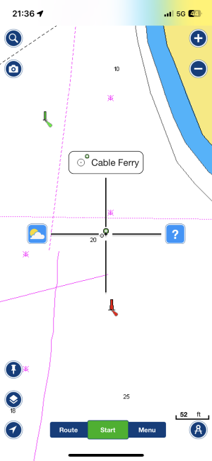
If you need a chart to identify that particular chain ferry rather than using No1 eyball then I wonder about was one keeping a good lookout with situational awareness whilst sailing.
srm
Well-Known Member
When a student on a MN electronic navigation aids course the instructors used to make the point that the "real world" is outside the wheelhouse (or for many of us the cockpit). The point being that GPS, Chart Plotters, Charts, RADAR, AIS, etc. etc. are no more than aids to safe navigation and are not infallible.If you need a chart to identify that particular chain ferry rather than using No1 eyball then I wonder about was one keeping a good lookout with situational awareness whilst sailing.
AntarcticPilot
Well-Known Member
Note also that except in th
In this case it's clear that the ferry was marked by appropriate marks, and in a narrow channel like that the chart plotter is the last thing anyone should be looking at, and then only for general situational awareness.
I think I've said it before, but the first tool for any navigation is your eyes. And I made maps for a living! But no map or chart is ever 100% up to date, or 100% correct! Using your eyes also has the advantage that things like datum shifts don't affect them.If you need a chart to identify that particular chain ferry rather than using No1 eyball then I wonder about was one keeping a good lookout with situational awareness whilst sailing.
In this case it's clear that the ferry was marked by appropriate marks, and in a narrow channel like that the chart plotter is the last thing anyone should be looking at, and then only for general situational awareness.
Alex_Blackwood
Well-Known Member
Bit like modern day weather forecasting. If you look out the window instead of at the computer model you might see what is really happening!When a student on a MN electronic navigation aids course the instructors used to make the point that the "real world" is outside the wheelhouse (or for many of us the cockpit). The point being that GPS, Chart Plotters, Charts, RADAR, AIS, etc. etc. are no more than aids to safe navigation and are not infallible.
Too much reliance on technology.
Last edited:
requiem
Well-Known Member
One of the risks with vector charts. Would be better if a certain level of detail was always present for a given zoom. Bit like a raster chart.
They aren't that much different; each vector chart has its intended compilation scale (just as a raster chart is drawn to a particular scale), with the features considered relevant for that scale included. If something's not visible at a given scale, that's no different from it having been left off a raster chart.
Now, it's possible some third party providers might mash everything together in a single file and hope it all works out, but at least for S-57 ENCs the same basic concepts apply as with paper.
oldmanofthehills
Well-Known Member
I have got used to Torpoint ferry but mildly alarmed when running nicely downwind in F5 and saw the third supposedly parked ferry start away as we approached to pass astern of 1 & 2. Let navigator start engine but held nerve and remain sail pureDon't forget the three chain ferries at Torpoint. That appear to leave at random times just to snag any passing yacht.
Love there Restricted in Ability to Manoeuvre signs and lights even though they do head off to Falmouth from time to time for servicing.
However on voyage in much earlier boat swerved toward the swanage shore to go behind the Poole Sandbanks ferry and ran aground on the shingle bank outside the moorings. Falling tide and took much kedging and winching to get us back to channel
Farmer Piles
Well-Known Member
Quite agree, the Mark 1 eyeball is still the best form of navigation in close quarters. That and common sense - although this isn't as common as one might expect.
Regarding maps and GPS; we have a farm track that runs beside a footpath and for some reason on some satnavs this is shown to be a road down to Mylor - our village. The ruts are about a foot deep yet still we get at least one van a year driving down it and getting stuck. Normally because they have grounded out. We are careful to remind them that they are responsible for damage to the underside of the van when we drag them out.
All our farm maps used to be based on the 1908 OS maps. To quote our old rural solicitor; they were the most definitive maps ever as they were done at the tail end of the Victorian era and "they had men crawling through bogs with tape measures". Now all the Rural Payment Agency maps are digital and done from satellite images and they are always getting it wrong. For example they don't allow for the trees overhanging fields around the edges when they calculate the field area.
Tangential I know but I am sure that you can extrapolate this to charts and chart plotters.
westernman
Well-Known Member
For the OP.
You made a mistake. Your insurance paid out. Suck it up.
We all make mistakes from time to time. That is why we have insurance. You have a deductible. This reduces the cost of your premium. You chose to do that, as most of us do,
Harsh, but I don't thing you stand a chance of getting any of your 1,500 back from anyone.
Best to move on rather than waste your life and money trying to recover any part of your deductible and uninsured losses.
NBs
Well-Known Member
Hi,
A bad accident, but you can't find the culprit, like in a mirror.
On the ferry it says "line ferry" on both sides and in addition it flashes powerful LEDs on both sides.
If you had looked carefully, you would have seen a huge cable reel. Based on your picture, the ferry was the Waxholm castle ferry.
Beautiful scenery, a lot of traffic and accidents can happen. Here everyone knows to avoid commercial vessels in archipelagic areas because the law says so.
Bilgediver
Well-Known Member
I think that reel on the side is a spool for power cable suggesting it is electrically powered . The guide propulsion cables will be hidden from view and pass through the ferry and connected to shore at each end of the run. All the more obstacles to avoid.