MattK1969
Active Member
Hi All
I was unfortunately involved in hitting the cable of a cable ferry in Sweden in a British Registered boat. Lost the rudder. Replacement cost about £ 7500 through insurance. Uninsured losses approx £ 1500.
I was using a garmin plotter. The plotter showed a ferry, but not a cable ferry. Garmin have confirmed it wasn't on the chart. The ferry folk swear it's on the chart.
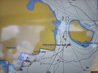
My chart info and track is shown on the attached picture. I was heading North and struck the cable where my track crosses the pink ferry line, just South-West of the green channel marker. Keeping to left of channel to avoid large oncoming commercial vessel. Managed to get into dock with the bow thruster.
I would like to have a stab at getting my uninsured losses back.
Questions :
Can I use English law?
Is Garmin liable?
Is the Ferry operator liable?
Should I just forget it?
Your thoughts would be very welcome.
Matt
I was unfortunately involved in hitting the cable of a cable ferry in Sweden in a British Registered boat. Lost the rudder. Replacement cost about £ 7500 through insurance. Uninsured losses approx £ 1500.
I was using a garmin plotter. The plotter showed a ferry, but not a cable ferry. Garmin have confirmed it wasn't on the chart. The ferry folk swear it's on the chart.
My chart info and track is shown on the attached picture. I was heading North and struck the cable where my track crosses the pink ferry line, just South-West of the green channel marker. Keeping to left of channel to avoid large oncoming commercial vessel. Managed to get into dock with the bow thruster.
I would like to have a stab at getting my uninsured losses back.
Questions :
Can I use English law?
Is Garmin liable?
Is the Ferry operator liable?
Should I just forget it?
Your thoughts would be very welcome.
Matt