C-map chart updates?

adamstjohn

Active member
Joined
16 Oct 2007
Messages
248
Visit site
Evening all. Apologies if this has already been covered elsewhere. Thought it wise to update charts on our standard horizon cp180.
Phoned the chandler who did it last time, 2015 apparently ? who said it’s all obsolete and we cannot update. we do use paper as well?
Anyway i have a cmap orange card
Ewm227
Nw euro coasts
Anybody got any ideas if I can keep this going cost effectively ?
Seems a bit of a waste to stop using a great piece of kit that suits our needs.
Ta
Adam
 

RAI

Well-known member
Joined
13 Jun 2006
Messages
15,848
Location
Ayamonte
Visit site
C-Map have abandoned their chip card format and Standard Horizon have abandoned their chart plotters. I have two of each, one used as radar and AIS display. They all work but no updates.
My plan is to use a tablet with Navi- whatever for updated charts and to check bouyage changes, harbour wall extensions etc., for each trip. Then use the plotters as usual.
 

adamstjohn

Active member
Joined
16 Oct 2007
Messages
248
Visit site
C-Map have abandoned their chip card format and Standard Horizon have abandoned their chart plotters. I have two of each, one used as radar and AIS display. They all work but no updates.
My plan is to use a tablet with Navi- whatever for updated charts and to check bouyage changes, harbour wall extensions etc., for each trip. Then use the plotters as usual.
Must admit this is possibly the route we will have to go now. thanks for advise.
 
Joined
27 Jun 2005
Messages
79
Location
Glos
Visit site
If it is the C-Map Max Orange cartridges then you can still get the updates -

C-MAP MAX Charts -says that the next update is March 2023 , but also that they will only be available in 2023 and will not be available from 2024 onwards. I can not find anything official from the CMap

Also can get from:

C-Map MAX MEGAWIDE Area - Update

or

C-Map MAX

Costs for updates are usually 50% of new cost.
 

Refueler

Well-known member
Joined
13 Sep 2008
Messages
20,470
Location
Far away from hooray henrys
Visit site
C-Map have abandoned their chip card format and Standard Horizon have abandoned their chart plotters. I have two of each, one used as radar and AIS display. They all work but no updates.
My plan is to use a tablet with Navi- whatever for updated charts and to check bouyage changes, harbour wall extensions etc., for each trip. Then use the plotters as usual.

I was a dedicated Plotter user and PC as well .... then along comes Navionics with their Boating and Lakes Android application ... (think they do Apple as well) ..... I downloaded for free .... ran the free trial and really liked it ... bought a new Android Tablet ... installed B&L on it ... paid the 39 euros annual fee for entire Baltic coverage download ...

I now have that installed on a tablet and my smartphone ... updates are frequent and free. End of year if I don't renew subscription - I still get to keep the charts downloaded - just no further updates.

I now have up to date Navionics on Phone + Tablet - as well as my full plotter with K Charts on board ... just about got it covered I reckon ....
 

adamstjohn

Active member
Joined
16 Oct 2007
Messages
248
Visit site
I was a dedicated Plotter user and PC as well .... then along comes Navionics with their Boating and Lakes Android application ... (think they do Apple as well) ..... I downloaded for free .... ran the free trial and really liked it ... bought a new Android Tablet ... installed B&L on it ... paid the 39 euros annual fee for entire Baltic coverage download ...

I now have that installed on a tablet and my smartphone ... updates are frequent and free. End of year if I don't renew subscription - I still get to keep the charts downloaded - just no further updates.

I now have up to date Navionics on Phone + Tablet - as well as my full plotter with K Charts on board ... just about got it covered I reckon ....
That does sound like the way to go doesnt it. I assume you just have AIS and DSC -from the plotter - running as before?

Any tablets you are able to recommend? My eyes are going a bit crap, wearing glasses for reading but nowt else, woul;d be lovely to have a larger screen in our not so large cockpit on a bulkhead (assume you may be able to buy a holder thing to temporarily mount?-rather than the 7" plotter on the chart table. It does get boring putting me specs on and peering down!!:)
Thanks
Adam
 

RAI

Well-known member
Joined
13 Jun 2006
Messages
15,848
Location
Ayamonte
Visit site
The single problem with a tablet as chart plotters is whether it is direct sunlight readable. Unlike a fixed chart plotter screen however it's easy to nip below with a tablet for some shade. Getting radar and AIS on the tablet is a techie issue. Any advice out there, thanks.
 

Refueler

Well-known member
Joined
13 Sep 2008
Messages
20,470
Location
Far away from hooray henrys
Visit site
That does sound like the way to go doesnt it. I assume you just have AIS and DSC -from the plotter - running as before?

Any tablets you are able to recommend? My eyes are going a bit crap, wearing glasses for reading but nowt else, woul;d be lovely to have a larger screen in our not so large cockpit on a bulkhead (assume you may be able to buy a holder thing to temporarily mount?-rather than the 7" plotter on the chart table. It does get boring putting me specs on and peering down!!:)
Thanks
Adam


The one thing I found out ages ago .... there are tablets at significantly less coast than Samsung etc ... with greater capability ...

I have some 'old' 10" tablets that still today put average Samsung to shame.

I decided to leave them as my video viewers / play tabs at home and looked at getting a new tablet dedicated to nav. I wanted 10" again .. but then after seeing the charts displayed on my Samsung phone ... decided that in fact an 8" is good enough ... large enough to see detail, small enough to go in pocket.

HEADWOLF FPad 1 UNISOC T310 Quad Core 3GB RAM 64GB ROM 4G LTE 8 Inch Android 11 Tablet

Fast ... crisp clear display ... built in GPS providing backup confirmation of plotter etc. I can feed all data via WiFi to it ...

Cheap holder from local car shop or supermarket ...

I don't try to say the above setup suits all .. it depends what you want to do .... for me - to cruise the Baltic / Swedish Islands etc. - it fits the bill.

My Plotter has full AIS Transceiver ... I have full service Multiplexor on board ... my VHF has DSC ..... Done deal.
Banggood have an amazing selection of tablets ....
 

Refueler

Well-known member
Joined
13 Sep 2008
Messages
20,470
Location
Far away from hooray henrys
Visit site
The single problem with a tablet as chart plotters is whether it is direct sunlight readable. Unlike a fixed chart plotter screen however it's easy to nip below with a tablet for some shade. Getting radar and AIS on the tablet is a techie issue. Any advice out there, thanks.

Radar on a Tablet is an issue ...

But AIS is not .... being an NMEA sentence format - it can easily go with other NMEA via WiFi or USB to Tablet / PC etc. I use the NMEA2WiFi plexor .....
 

RAI

Well-known member
Joined
13 Jun 2006
Messages
15,848
Location
Ayamonte
Visit site
Radar on a Tablet is an issue ...

But AIS is not .... being an NMEA sentence format - it can easily go with other NMEA via WiFi or USB to Tablet / PC etc. I use the NMEA2WiFi plexor .....
Thanks for that.
My radar talks to the plotter with NMEA messages, so does the compass but the tablet needs an app to display the information.
 

Refueler

Well-known member
Joined
13 Sep 2008
Messages
20,470
Location
Far away from hooray henrys
Visit site
Thanks for that.
My radar talks to the plotter with NMEA messages, so does the compass but the tablet needs an app to display the information.


OK .... I've not delved into Radar .... but judging by a recent thread about Radar and connecting to other 'gear' - I suggest you are very lucky.

Many Tablet Nav apps will accept AIS sentences .....
 

wonkywinch

Well-known member
Joined
30 Jul 2018
Messages
2,037
Location
Hamble, UK
Visit site
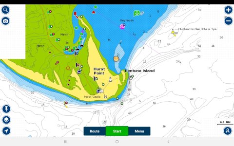
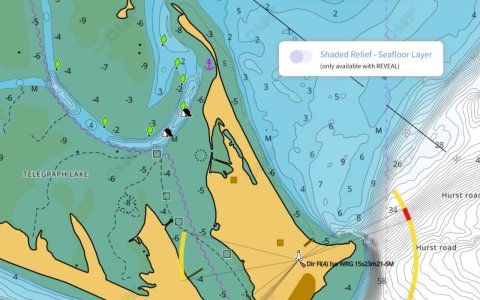
Same subject, different topic. I recently changed from Navionics to C-Map as the new Zeus S doesn't accept Navionics. I updated the C-Map card and also use a C-Map subscription on an ipad. It seems their updates are a little behind for the Solent so I raised this as an issue with them.

navionics.jpg

Current Navionics above

cmap.jpg


Current C-Map (updated card and their live online map)
 
Top