Best UK Weather Model?

Foxglove

New Member
Joined
8 Jun 2022
Messages
12
Visit site
Hi All,

I have a horrible feeling there's no straight answer to this, but I've downloaded a couple of wind/weather apps and am faced with forecasts from half a dozen or more weather 'models'.
Is there one model which generally outperforms the others for accuracy and consistency? Which model do you all tend to use? I'm on the South Coast of the UK, if that helps.
 
It's all a prediction but it depends on what specific parameters of weather you are after, I only do coastal cruising so find Windy is OK but I also use a Gliding/Soaring app from my gliding days called RASP that is excellent for my needs.
 
One of the advantages with Windy is that it can display several different weather models so you can compare them. Then choose the one that gives the answer you were hoping for :)

On a more serious note - if all/most of the models agree on something, there's a greater likelihood that it will be correct.
 
As a direct answer, I like the granularity on ECWMF, and use AROME for short-term forecasts too. As I only do very local stuff these days the 13km or 22km data points of ICON and GFS are too far apart, so the models are no use to me.

I attended a PredictWind webinar last year and they spoke about the application of the models - essentially they all have trouble with coastal cruising due to the short-term impact that the land mass can have. Apparently this is being studied and put into the models so they will get better over time, but the closer you are to land, the finer the granularity is needed. Also, in EU the ECWMF and AROME models are apparently better than GFS (which is better in the US), but as mentioned by others it pays to start watching and comparing the models a few days out and seeing if they agree or diverge. If the models do not agree and there is a front coming over, then pack everything just in case! If the models agree and the pressure system is stable then you can be fairly confident in the forecast - but again, if coastal sailing, the land mass can introduce a local effect/microclimate so this needs to be taken into account.
 
A slightly broader answer to your question, but the app that has gained my trust is WillyWeather. It states that it uses “information produced by external organisations including the Met Office, United Kingdom Hydrographic Office (UKHO), EUMETSAT and the National Oceanic and Atmospheric Administration (NOAA).”

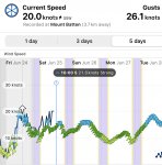
Regardless of the model it uses, I like it because it displays how accurate its predictions have been over the past 24 hours. It’s usually very good (the black line in the image is the actual wind). It also displays an actual wind reading in real time (I’m in Plymouth and it provides the current anenometer reading from Mountbatten pier).

The app is also good for tide (including percentage springs) and swell predictions. I find it a good ‘one stop shop’.

D63140D1-FA85-4305-85E4-C2D61FFA2524.jpeg
 
A slightly broader answer to your question, but the app that has gained my trust is WillyWeather. It states that it uses “information produced by external organisations including the Met Office, United Kingdom Hydrographic Office (UKHO), EUMETSAT and the National Oceanic and Atmospheric Administration (NOAA).”

Regardless of the model it uses, I like it because it displays how accurate its predictions have been over the past 24 hours. It’s usually very good (the black line in the image is the actual wind). It also displays an actual wind reading in real time (I’m in Plymouth and it provides the current anenometer reading from Mountbatten pier).

The app is also good for tide (including percentage springs) and swell predictions. I find it a good ‘one stop shop’.

View attachment 137482
Thanks for that -I quite like the format.
 
@franksingleton , a denizen of these pages and a veteran of weather forecasting, has a series of web pages at Frank Singleton's Weather and Sailing Pages - Franks-Weather - The Weather Window that give chapter and verse for most things to do with weather modelling , includuing his take on various weather models. For the UK, the Met Office models are the best, but are not so readily available as (say) ECWMF.
Great steer - thank you! Will check out Frank’s pages.
 
A slightly broader answer to your question, but the app that has gained my trust is WillyWeather. It states that it uses “information produced by external organisations including the Met Office, United Kingdom Hydrographic Office (UKHO), EUMETSAT and the National Oceanic and Atmospheric Administration (NOAA).”

Regardless of the model it uses, I like it because it displays how accurate its predictions have been over the past 24 hours. It’s usually very good (the black line in the image is the actual wind). It also displays an actual wind reading in real time (I’m in Plymouth and it provides the current anenometer reading from Mountbatten pier).

The app is also good for tide (including percentage springs) and swell predictions. I find it a good ‘one stop shop’.

View attachment 137482
Always in the market for another weather app! Will investigate. Many thanks!
 
As a direct answer, I like the granularity on ECWMF, and use AROME for short-term forecasts too. As I only do very local stuff these days the 13km or 22km data points of ICON and GFS are too far apart, so the models are no use to me.

I attended a PredictWind webinar last year and they spoke about the application of the models - essentially they all have trouble with coastal cruising due to the short-term impact that the land mass can have. Apparently this is being studied and put into the models so they will get better over time, but the closer you are to land, the finer the granularity is needed. Also, in EU the ECWMF and AROME models are apparently better than GFS (which is better in the US), but as mentioned by others it pays to start watching and comparing the models a few days out and seeing if they agree or diverge. If the models do not agree and there is a front coming over, then pack everything just in case! If the models agree and the pressure system is stable then you can be fairly confident in the forecast - but again, if coastal sailing, the land mass can introduce a local effect/microclimate so this needs to be taken into account.
I like a bit of granularity, too, @Moodysailor. Interesting re coastal waters and the effect of local topography.

Your point about the 13km or 22km data points of ICON and GFS - what does that refer to? Weather stations at 13/22km intervals? Excuse my ignorance!
 
Take into account the purpose of the models too. ECMWF in particular is a medium range weather forecast so tends to be better for next week whereas others are better at tomorrow.
 
Meteorology is an open science undef the WMO umbrella with no secrets between the major modelling centres. Commercial firms running models - e.g. Predicteind and Spire have “trade secrets.” All models use the same physical equations but many approximations and estimates are used.
ECMWF and the UK UM use grid lengths of 0.1 degree lat/Lon, quoted variously as 9 or 10km. They outperform the rest. ECMWF beats the UK mainly because they run their model 2 hours later, have later data and, having no operational pressures, can spend more time on the analysis process. Also, they use more levels in the vertical so defining the atmosphere better.
Most other models use grid lengths of about 0.125 degree, with more levels then the UK but less than ECMWF. These models GFS, and ICON are the best know, are slightly behind the UK.

As always, there are “Howevers.”

1. All models have in-built smoothing so that the effective resolution is about 4 or 5 grid lengths. Nobody (me apart in my two books) ever tells you that.

2. There are always uncertainties in the initial data analysis. That, together with the approximations and estimates, is why modelling centres run ensembles. On the Meteociel site you can see tables of the effects of small variations in the data for the GFS and other models. ECMWF ensembles vary data and estimated values but a tabulated set of results is not freely available.

3. Small weather features have short lifetimes and are not predictable in a deterministic sense. My usual example is an individual thunderstorm with a total life span of less than 6 hours. While detailed models, AROME, HARMONIE, ICON-DE etc are capable of predicting topographic effects they may not do so in practice if small detail such as cloud amount or precise wind direction are not well forecast.

My experience is that, usually, over the first few days, the main models produce forecasts that are within the uncertainty range of each other- say, within 5 knots and a few degrees direction. If one is an outlier, do not, as some people suggest, take an average of the rest. Trust none, the outlier could be best on the day. If all are similar, it is encouraging but no more. It is rare but all might well be wrong in the particular area of interest to you.

More in another post.
 
Last edited:
I am in a French marina with slightly uncertain wifi. Hence I am splitting my overlong reply.

ECMWF issues its freely available forecasts twice a day and later than the rest. Their output is 2 hours later than the GFS and 3 later than ICON. But, Windy, Ventusky, Westhertrack can be later still. In the case of Windy, over 3 hours later. For much of the time, the latest ECMWF forecast will be based on earlier data than the rest. Given their superior model and analysis, this will not matter most of the time but may do so occasionally. I always like to see forecasts using latest data.

Beyond r or 5 days, ECMWF should be best. My personal approach is to use either ECMWF or the GFS. I compare output 24 hours apart and look for consistency 7, 8, 9, 10 days ahead. When I see a similar story, then I plan with some confidence. If I see lack of consistency, I cannot plan sensibly.

In summary, for the first few days, there is little to choose between models. Differences are generally random. The “granularity” somebody mentioned has to be viewed in light of Yuen smoothing. ECMWF can only resolve detail of around 50 km, GFS, ICON etc can only resolve to about 70km. Small detail is inherently unpredictable in a sense useful to us sailors.

minPiddy may have a different take as she works st ECMWF
 
Last edited:
AFAIK all the weather apps use the same base information so it all boils down to presentation. Pick the one you like the look of best.
Not as far as I am aware. Many use GFS, but others use differnt models like UK Met and other national models, some use a choice of multiple models. So worth knowing the model used behind the app
 
Synoptic, o-level geography and experience is what I use. Look at the sky if you want to know what the weather is doing in the next few hours. As for tomorrow it will probably be like today. Use the synoptic to guess where the systems are moving to for the day after tomorrow.
 
Not as far as I am aware. Many use GFS, but others use differnt models like UK Met and other national models, some use a choice of multiple models. So worth knowing the model used behind the app
Ghostlymoron was not correct but was, in essence, reflecting what many apps do and what many users do.

Many apps use the GFS because it has long been freely available ie back to 1999 in GRIB format. The Canadian model and the US Navy have also long been available. Some apps provide them but I have rarely heard of them being used. The German ICON and Meteo France ARPEGE are also now freely available. I rarely hear of anyone using ARPEGE. I know of no free UK GRIB apps.

The limited free ECMWF data are only available on a 40km grid, I.e.they are a subset of the model output. However, noting the effective resolution, there is little real loss of information. The free ECMWF GRIB data are, I understand, made available an hour after the model is scheduled to provide output to its owners I.e. the European Met services such as the UK. What Windy.com gets is a bit of a mystery. They seem to offer more than the free limited output but are late in putting the data on their app.

Some other third party suppliers offer a range of models. XyGrib is particularly good but only useable on laptops. WeatherTrack has a range of models but I do not find their app particularly easy to use. Ventusky has a good range of outputs and I find it clearer than Windy.com.
 
Top