App To Import Tracks, Image for Journal / Web

RunAgroundHard

Well-known member
Joined
20 Aug 2022
Messages
2,245
Visit site
I am looking for an App to import routes into and show the track It doesn’t have to be a detailed chart as it is for overview purposes only.

The plan is to include an image of the chart with track in a journal that can be viewed on a web page or incorporated in a document for printing. Why, when I retire soon I want to record some of my trips and write them up.

Any ideas? An age ago I used Ozzy Explorer for motocross tracks.

Thanks in advance.
 

KeelsonGraham

Well-known member
Joined
6 Jul 2021
Messages
469
Visit site
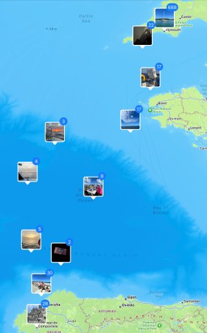
Navionics at about £40 per year does this. Alternatively, take a photo on an iPhone and it will geolocate it, no matter where you are on the ocean. Open the ‘Places’ album and you’ll see exactly where you’ve been.
 

Attachments

  • IMG_5125.jpeg
    IMG_5125.jpeg
    1.6 MB · Views: 4

wonkywinch

Well-known member
Joined
30 Jul 2018
Messages
2,036
Location
Hamble, UK
Visit site
If you search for an online gpx editor, you can edit the file before uploading, eg to remove a load of unwanted points at the beginning or end of your trip where the chart plotter was recording stationary segments.
 

RunAgroundHard

Well-known member
Joined
20 Aug 2022
Messages
2,245
Visit site
If you search for an online gpx editor, you can edit the file before uploading, eg to remove a load of unwanted points at the beginning or end of your trip where the chart plotter was recording stationary segments.

Aye, thanks for that. It was what I was thinking after reading tehthread replies, that there will be a bunch of track points in there that are not required. I am interested in just showing overall A to B tracks, not the MOB drill track or even beating tracks. Hence editing will be a useful feature.
 

GHA

Well-known member
Joined
26 Jun 2013
Messages
12,458
Location
Hopefully somewhere warm
Visit site
If you search for an online gpx editor, you can edit the file before uploading, eg to remove a load of unwanted points at the beginning or end of your trip where the chart plotter was recording stationary segments.
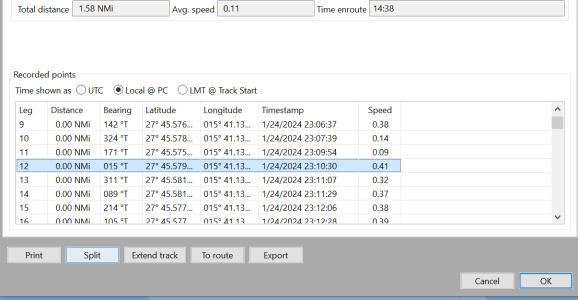
Far, far easier in opencpn. Split the track where the speed is near zero or based on a time or Lat/long. Split button does just that, creates 2 tracks.
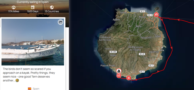
And noforeignland streets ahead as well in ease of use to faffing about with google maps, just email the track or use one of the many options to get data in there. NOFOREIGNLAND
Been doing this for donkeys years, finally it's easy.


1706955202005.png
 

dansaskip

Well-known member
Joined
12 Nov 2004
Messages
661
Location
Various
seabear.uk
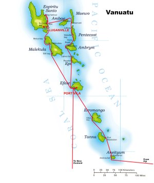
An alternative approach if you have access to a photo editing programme is to overlay your route by drawing it in using another layer. That is eventually the approach I took and I think it worked quite well and avoided having to edit the track which I didn't have anyway. Another advantage was I could add place names that were not on the map but places I had visited. Attached an example.vanuatu with Sea Bears route copy.jpg
 

dunedin

Well-known member
Joined
3 Feb 2004
Messages
13,961
Location
Boat (over winters in) the Clyde
Visit site
An alternative approach if you have access to a photo editing programme is to overlay your route by drawing it in using another layer. That is eventually the approach I took and I think it worked quite well and avoided having to edit the track which I didn't have anyway. Another advantage was I could add place names that were not on the map but places I had visited. Attached an example.
Per post #2 above, I use GPS Track editor - but then save a high resolution screenshot of the resultant track, and then use a basic photo editor to add names for key locations - eg start and end ports, key places visited.

One thing that is important if intending to use for presentations and/or posting a blog on a website is to ensure you have thought about and complied with the copyright aspects. I see lots of presentations where people have, as far as I can see, breached copyright by using screenshots of Navionics, UKHO etc charts without proper attribution.

I think GPS Track Editor uses OpenSeaMap which, AFAIK, is free to use provided source acknowledged. Hence I use this and make sure the relevant text is added (via the photo editor) if cropped off or not clearly visible.
Ditto if using Google maps or similar, read their copyright rules and include the relevant text - easily done.
 
Top