simonjk
Well-known member
Hello again,
Thanks to all of you who are using SWIS. Take a look for yourself at http://www.sailingweather.co.uk Forecasts are free and updated 3xper day. This service is developing all the time and I’ll be announcing some exciting enhancements soon.
If you want to learn more about the weather then the next Sailing Weather School (Part 1) is to be held in Southampton on Saturday 5th March. There are three places left on this, so if you want to come along book your place now at http://www.weatherschool.co.uk This course is for all sailors, whatever your experience. You will learn so much about the weather and how you can optimise your sailing by making better assessments of weather patterns.
Onto the weekend forecast, and if you know anyone who’d like to receive this email each week just tell them to send a request to join to
sailingweather-subscribe@weatherweb.net Also, feel free to forward this email to onto any flying friends or groups.
Have a good weekend,
Simon
WEEKEND WEATHER FORECAST
Issued: 1000 Friday 18th February 2011
SATURDAY
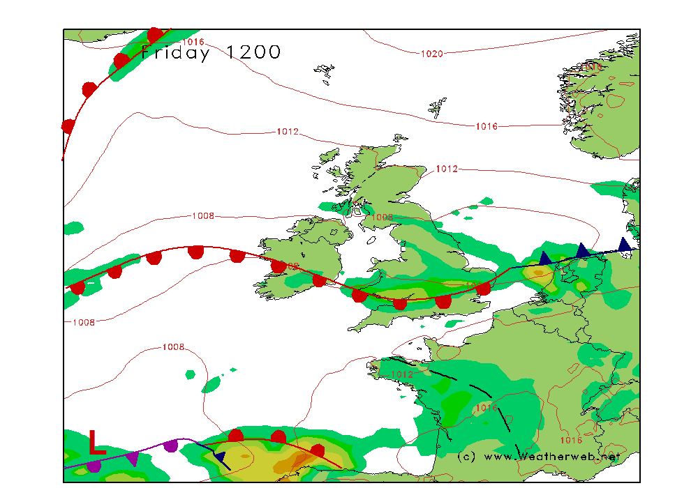
An occluded front is going to be edging slowly eastwards through the day. This feature becomes virtually stationary off the east coasts I the evening. A weak ridge of high pressure builds behind the front through the afternoon, as the trough over Northern Ireland and Wales weakens.
A wet start to the day for most of Scotland, central and eastern parts of England with snow on the hills in the north. Visibility in this area will be moderate or poor in the rain and snow. The area of rain edging very slowly eastwards, and it may well be late afternoon before rain clears eastern coasts. Windy to the east too.
More western areas should be drier, although there will be showers along the line of the trough from Northern Ireland to Wales, during the morning. These showers should fade through the morning, leaving the afternoon drier and brighter as the sun comes out. Visibility through more western areas improving through the day.
Much of the south of Ireland should be fair with some sunny spells, although cloud increasing in western Ireland later as the winds increase later.
Winds will be mainly SE 14-18kt (F5) to the east occ 24kt (F6) becoming S 8-10kt (F3) to the west of the front.
SUNDAY
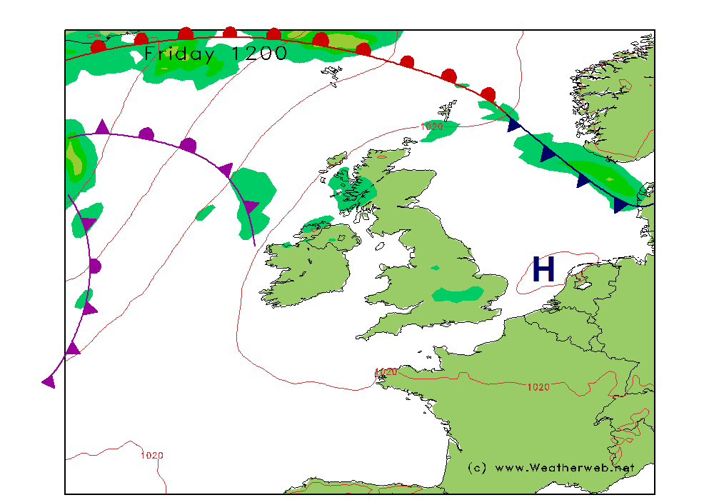
An occluded front remains along eastern coasts through Sunday with the front moving very little. A further occluded front moving into western Ireland, this edging slowly eastwards.
There will be lots of low cloud and outbreaks of drizzle through the morning. Misty conditions with poor visibility for many areas, although a slow improvement through the Midlands and northwest England as well as Scotland. Staying damp and cloudy in many eastern areas throughout the day, but drier to the west.
The occluded front over western Ireland will be bringing rain here, some of it heavy at times as it edges eastwards through the course of the day.
Winds mainly SE 16-20kt (F5) in the morning, although SE 3-6kt (F2) over southeast England at first. The winds steadily increasing here with all areas SE 17-22kt (F5) for most in the afternoon.
***ends***
Thanks to all of you who are using SWIS. Take a look for yourself at http://www.sailingweather.co.uk Forecasts are free and updated 3xper day. This service is developing all the time and I’ll be announcing some exciting enhancements soon.
If you want to learn more about the weather then the next Sailing Weather School (Part 1) is to be held in Southampton on Saturday 5th March. There are three places left on this, so if you want to come along book your place now at http://www.weatherschool.co.uk This course is for all sailors, whatever your experience. You will learn so much about the weather and how you can optimise your sailing by making better assessments of weather patterns.
Onto the weekend forecast, and if you know anyone who’d like to receive this email each week just tell them to send a request to join to
sailingweather-subscribe@weatherweb.net Also, feel free to forward this email to onto any flying friends or groups.
Have a good weekend,
Simon
WEEKEND WEATHER FORECAST
Issued: 1000 Friday 18th February 2011
SATURDAY
An occluded front is going to be edging slowly eastwards through the day. This feature becomes virtually stationary off the east coasts I the evening. A weak ridge of high pressure builds behind the front through the afternoon, as the trough over Northern Ireland and Wales weakens.
A wet start to the day for most of Scotland, central and eastern parts of England with snow on the hills in the north. Visibility in this area will be moderate or poor in the rain and snow. The area of rain edging very slowly eastwards, and it may well be late afternoon before rain clears eastern coasts. Windy to the east too.
More western areas should be drier, although there will be showers along the line of the trough from Northern Ireland to Wales, during the morning. These showers should fade through the morning, leaving the afternoon drier and brighter as the sun comes out. Visibility through more western areas improving through the day.
Much of the south of Ireland should be fair with some sunny spells, although cloud increasing in western Ireland later as the winds increase later.
Winds will be mainly SE 14-18kt (F5) to the east occ 24kt (F6) becoming S 8-10kt (F3) to the west of the front.
SUNDAY
An occluded front remains along eastern coasts through Sunday with the front moving very little. A further occluded front moving into western Ireland, this edging slowly eastwards.
There will be lots of low cloud and outbreaks of drizzle through the morning. Misty conditions with poor visibility for many areas, although a slow improvement through the Midlands and northwest England as well as Scotland. Staying damp and cloudy in many eastern areas throughout the day, but drier to the west.
The occluded front over western Ireland will be bringing rain here, some of it heavy at times as it edges eastwards through the course of the day.
Winds mainly SE 16-20kt (F5) in the morning, although SE 3-6kt (F2) over southeast England at first. The winds steadily increasing here with all areas SE 17-22kt (F5) for most in the afternoon.
***ends***