simonjk
Well-Known Member
****
ARE YOU WEATHER WHYS?
Learn more about the weather with my books and DVD's.
See free samples online at http://www.weatherweb.net.books.htm
*****
Good morning,
Not looking too bad a weekend to get the boat ready for spring!
We will be here all weekend, you can talk to a forecaster live between 8am and 6pm on 0906 515 0046 (calls cost £1.53 per minute) and get a forecasts specifically for you (both myself and John are manning the lines this weekend).
The Sailing Weather Information Service is becoming ever more popular and you can get your free 14-day trial by registering now at www.sailingweather.co.uk. Remember our forecasts are available by the web, and text message, and they could the UK, Ireland and Europe.
If you have a friend who would like to receive this forecast by email each week ask them to subscribe by emailing sailingweather-subscribe@weatherweb.net
Have a great weekend,
Simon
WEEKEND WEATHER FORECAST
===========================
Issued 1300 Friday 1st March 2013
Saturday:
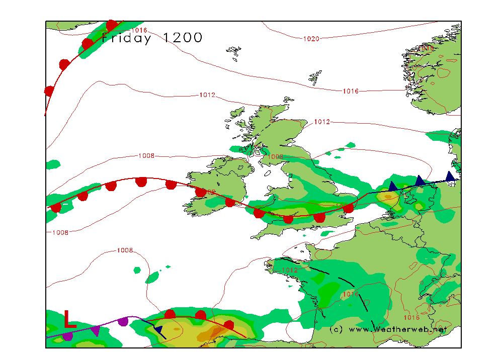
High pressure dominates the weather across the British Isles and Ireland on Saturday. A cold front moving into northern Scotland will be bringing some outbreaks of rain here.
The ridge of high pressure brings some morning mist and fog patches, most of these through the western Midlands, Wales and Ireland. However, we expect these to be clearing quite quickly through the morning to leave sunny spells and broken cloud.
There may be some thicker cloud affecting the far southeastern corner of England, and southern coasts, perhaps thick enough to produce some spots of drizzle. This probably fades into the afternoon with some sunny spells forming.
Winds NW 12-15kt (F4) in northern Scotland, NE 8-10kt (F3) in southern England, variable 2-5kt (F1-F2) elsewhere.
Sunday:
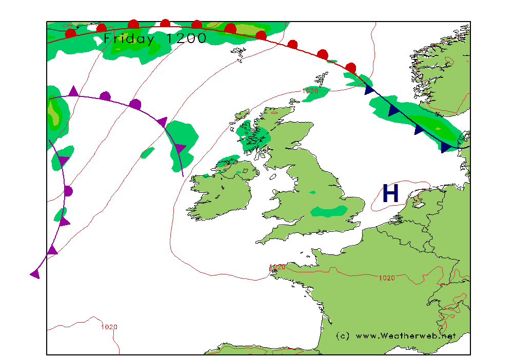
The area of high pressure is expected to be off eastern coasts of England on Sunday. A warm front passes close to northern Scotland.
There will be some cloud and drizzle affecting northern Scotland, this also affecting the western Ireland too. Visibility may be poor here.
Elsewhere fog may be more widespread over England and Wales as well as Ireland and southern Scotland. This reluctant to clear from parts of the Midlands, northern England and southern Scotland through the day.
Where it does the day will be bright with sunny spells. The best sunshine probably in the southwest where the breeze will be picking up later.
Winds WSW-SW 8-10kt (F3-F4) in northern Scotland, SE 6-9kt (F3) over Ireland, Wales and southern England, variable 1-4kt (F1-F2) in northern England, but SE 12-17kt (F4-F5) later in southwest England and southern Ireland.
***ends***
--
ARE YOU WEATHER WHYS?
Learn more about the weather with my books and DVD's.
See free samples online at http://www.weatherweb.net.books.htm
*****
Good morning,
Not looking too bad a weekend to get the boat ready for spring!
We will be here all weekend, you can talk to a forecaster live between 8am and 6pm on 0906 515 0046 (calls cost £1.53 per minute) and get a forecasts specifically for you (both myself and John are manning the lines this weekend).
The Sailing Weather Information Service is becoming ever more popular and you can get your free 14-day trial by registering now at www.sailingweather.co.uk. Remember our forecasts are available by the web, and text message, and they could the UK, Ireland and Europe.
If you have a friend who would like to receive this forecast by email each week ask them to subscribe by emailing sailingweather-subscribe@weatherweb.net
Have a great weekend,
Simon
WEEKEND WEATHER FORECAST
===========================
Issued 1300 Friday 1st March 2013
Saturday:
High pressure dominates the weather across the British Isles and Ireland on Saturday. A cold front moving into northern Scotland will be bringing some outbreaks of rain here.
The ridge of high pressure brings some morning mist and fog patches, most of these through the western Midlands, Wales and Ireland. However, we expect these to be clearing quite quickly through the morning to leave sunny spells and broken cloud.
There may be some thicker cloud affecting the far southeastern corner of England, and southern coasts, perhaps thick enough to produce some spots of drizzle. This probably fades into the afternoon with some sunny spells forming.
Winds NW 12-15kt (F4) in northern Scotland, NE 8-10kt (F3) in southern England, variable 2-5kt (F1-F2) elsewhere.
Sunday:
The area of high pressure is expected to be off eastern coasts of England on Sunday. A warm front passes close to northern Scotland.
There will be some cloud and drizzle affecting northern Scotland, this also affecting the western Ireland too. Visibility may be poor here.
Elsewhere fog may be more widespread over England and Wales as well as Ireland and southern Scotland. This reluctant to clear from parts of the Midlands, northern England and southern Scotland through the day.
Where it does the day will be bright with sunny spells. The best sunshine probably in the southwest where the breeze will be picking up later.
Winds WSW-SW 8-10kt (F3-F4) in northern Scotland, SE 6-9kt (F3) over Ireland, Wales and southern England, variable 1-4kt (F1-F2) in northern England, but SE 12-17kt (F4-F5) later in southwest England and southern Ireland.
***ends***
--