Trying to learn Charts - Need help understanding compass roses

DangerousPirate

Well-Known Member
Joined
24 Feb 2020
Messages
1,023
Location
N. Ireland
Visit site
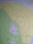
Hello, I was trying to figure out magnetic north on my chart and can't wrap my head around it.
The compass rose reads "Variation 0° 25' W (2016) Decreasing about 9' annually"

Does it mean that magnetic north is at 70°W? Or does that mean that magentic north is at 20° E? Or do I have to transfer the minutes to degrees first? It just dawned on me that it also could mean that the 70' W could be 1° 10'W, ergo 1°W?

I am not entirely sure what to do here.
 

Attachments

  • IMG_20210228_231223245-min.jpg
    IMG_20210228_231223245-min.jpg
    102.7 KB · Views: 50
It means what it says (which isn't very helpful if you don;'t understand it!) but remember that there are 60 minutes to a degree.

It means that in 2016 magnetic N was 0 degrees and 25 minutes West of true north. In other words just under half a degree difference. It also say that its decreasing by 9' annually so as there's 5 years between 2016 and 2021 that's 5x9=45minutes difference and it was getting less. So after three years Magnetic North was within 2 minutes of true N and it presumable has carried on moving and has passed through true North and is now 20 minutes East.

Not sure where you are getting 70 degrees W from.
 
I got the same result as John Morris. He explains it very well. The change in variation over the 5 years since the chart was published has moved magnetic north in the region covered by the chart from 25 minutes west of true north to 20 minutes east of due north, which being less than a half of a degree, you could not measure on a compass rose calibrated in full degrees in any case. Essentially, the variation from true north is so small that you can ignore it for the next few years.
 
45 + 25=70 BUT I forgot thats in minutes, and minutes only go to 60. So 1° 10' W. Now I know it is wrong, but thats where it came from.

Alright, I think I understand it better now. Charts are fun, but a lot more complicated than a chartplotter.

Edit: Yes, I know it is not significant but I just wanted to learn the principle of this calculation. What confused me, and maybe confuses others at first; The difference between degrees and minutes, and you mustn forget conversion.

Additionaly you have to grasp the idea of the decrease. It is not like arimethic where -20 - 10 = -30 (further decreasing).
 
Charts are indeed great fun, and full of interesting and helpful details that I can only see on a plotter by zooming in and out. I think you can’t beat them for passage planning.
 
45 + 25=70 BUT I forgot thats in minutes, and minutes only go to 60. So 1° 10' W. Now I know it is wrong, but thats where it came from.

Alright, I think I understand it better now. Charts are fun, but a lot more complicated than a chartplotter.

Edit: Yes, I know it is not significant but I just wanted to learn the principle of this calculation. What confused me, and maybe confuses others at first; The difference between degrees and minutes, and you mustn forget conversion.

Additionaly you have to grasp the idea of the decrease. It is not like arimethic where -20 - 10 = -30 (further decreasing).
Correct. And although it doesn’t seem to make much difference on this chart, wait until you sail in other parts of the world where variation can be 20 or 25 degrees or more.
 
, In working out the variation on your chart, I started with the annual change in variation and multiplied it by the number of years since the chart was published - 9’ X (2021-2016) = -9 X 5 = -45, or a decrease of 45’ in 5 years. This moves magnetic north from 25’ west of true north to 20’ east of true north. It is a bit of an odd case because the chart says “decreasing 9’ annually” and you have to realise that decreasing westerly variation is the same as adding easterly variation, which is really what is happening here. Variation is changing in an easterly direction from west of true north to east of true north. I had to look at it twice to be sure.
 
Someone on a related forum posted an article that said the earth’s magnetic field is changing very rapidly right now, so it is possible that those annual change rates on older charts may have to be updated.
 
On charts true north is depicted by the compass rose. True north at the top. Magnetic north is depicted by the added arrow. What has OP confused is the small variation true to magnetic such that he did not appreciate the arrow and the 0 of compass rose are not coincidental but with half a degree of difference so hard to notice.
Variation of course varies with location so here in Perth (west oz) we have about 3 degrees west. If I drive to Kalgoorlie about 600km it becomes 0 if I continue east it goes to an east variation. So irf Op sails in the area of his chart he can virtually ignore variation but as said not if he goes to other places. ol'will
 
I suppose all this will soon become irrelevant for the Americans, as their hydrographic office has just announced that they are phasing out paper charts.
 
I must admit that I haven't used paper charts for many years now but still remember carefully compensating for variation, deviation, tidal drift, leeway etc. on North Sea voyages.

I used CADET for variation. I seem to remember that there were others but they didn't really stick in my mind as CADET was so easy to use. Going from Compass to True, Add Easterly. Obviously subtract Westerly and just do the opposite of CADET when going from True to Compass.

I learned to use it about 50 years ago and probably haven't even thought of it for about 15-20 years.
 
  • Like
Reactions: jac
I seem to remember that there were others but they didn't really stick in my mind as CADET was so easy to use.

Personally I find it harder to remember whether or not the cadets are true virgins than simply to visualise (no imagination necessary with new charts where the compass rose does all the work for you but still not hard even where variation has changed direction since the chart was published) where magnetic north is relative to true north and add or subtract accordingly.

However my YM theory instructor insisted on trying to teach us these and obviously they work well for a lot of people. Is it a generational thing that people who were at school in the 50s got used to learning by smutty mnemonics?

If you learn compass to true that way (ie CADET) does the reverse work equally, do you use another acronym for true to compass or does it take a moment extra to process (like me trying to tie a bowline "back to front")?

Is the current negligible variation in the middle of the south coast which even those of us who are fairly fastidious about our nav ignore a problem for yachting instructors?
 
Last edited:
Personally I find it harder to remember whether or not the cadets are true virgins than simply to visualise (no imagination necessary with new charts where the compass rose does all the work for you but still not hard even where variation has changed direction since the chart was published) where magnetic north is relative to true north and add or subtract accordingly.

However my YM theory instructor insisted on trying to teach us these and obviously they work well for a lot of people. Is it a generational thing that people who were at school in the 50s got used to learning by smutty mnemonics?

If you learn compass to true that way (ie CADET) does the reverse work equally, do you use another acronym for true to compass or does it take a moment extra to process (like me trying to tie a bowline "back to front")?

Is the current negligible variation in the middle of the south coast which even those of us who are fairly fastidious about our nav ignore a problem for yachting instructors?

Cadbury's Dairy Milk, Very Tasty
True Virgins Make Dull Company

CADET is different
 
Top