Stone Heaps

TetleyK

Member
Joined
19 Sep 2021
Messages
38
Visit site
I'm trying to locate the position of the anchorage known as Stone Heaps on the River Orwell. I've seen it mentioned a number of times in articles and weblogs but it seems to be one of those places that is not marked on the chart, or not in the charts to which I have access.

I think it is just inshore and a little South of the red buoy (QR) called Orwell where the Imray chart shows an anchor symbol (51º 58'.07N 1º 16'.54E) but this is a guess.

Can anyone confirm this or, if I have that wrong, tell me where Stone Heaps is located.

Thanks.
 

tillergirl

Well-known member
Joined
5 Nov 2002
Messages
8,386
Location
West Mersea
Visit site
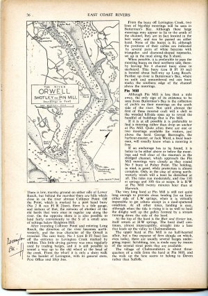
In Jack Coote's first edition (1956) of East Coast Rivers published by Yachting Monthly says "East Shotley Anchorage - there is a useful anchorage just inside the river and on the W shore, roughly NE of E Shotley Martello Tower (now topped by a large green water tank). This spot is known as Stone Heaps, and there is something of a hard on which to land, and a footpath that can be followed via the sea wall into the village of Shotley Gate.

Even today a barge or two will usually be brought up, waiting a tide at Stone Heaps. The holding in mud is good, but care must be taken to anchor out of the channel and yet in enough water to remain afloat. This is not always as easy as it seems, as the edge of the channel is quite steep-to. A riding light is essential. At around HW, it is possible to land on the E shore of the river near the old Martello Tower at a spot which was once the Walton Ferry Hard.'

Today's ECP 'To port, a little N of Shotley Marina, the river opens out into a gentle bay, called Stone Heaps, the name being a legacy from the old barging days which offers a good anchorage, if a little rough when ships pass. The holding is good, water is plentiful at all states of the tide and a shingle beach offers clean landing for a walk around the back of the marina to Shotley'
 
Last edited:

TetleyK

Member
Joined
19 Sep 2021
Messages
38
Visit site
In Jack Coote's first edition (1956) of East Coast Rivers published by Yachting Monthly says "East Shotley Anchorage - there is a useful anchorage just inside the river and on the W shore, roughly NE of E Shotley Martello Tower (now topped by a large green water tank). This spot is known as Stone Heaps, and there is something of a hard on which to land, and a footpath that can be followed via the sea wall into the village of Shotley Gate.

Even today a barge or two will usually be brought up, waiting a tide at Stone Heaps. The holding in mud is good, but care must be taken to anchor out of the channel and yet in enough water to remain afloat. This is not always as easy as it seems, as the edge of the channel is quite steep-to. A riding light is essential. At around HW, it is possible to land on the E shore of the river near the old Martello Tower at a spot which was once the Walton Ferry Hard.'
That is much appreciated.

It would seem that the anchorage I mentioned is not Stone Heaps as this is pretty much N of the E Shotley Martello Tower, which I assume is the water tower marked on the charts west of Shotley Marina. Jack Coote's description would put Stone Heaps on the edge of Shotley Marina around about here: 51º 57'.71 N 1º 16'.66 E

Thanks.
 

tillergirl

Well-known member
Joined
5 Nov 2002
Messages
8,386
Location
West Mersea
Visit site
I guess about 51.57'67N on Jack's chartlet. And of course Jan's today ECR says 'However, the proximity of the extended Trinity container terminal at Fagbury Point on the opposite bank makes the Stone Heaps anchorage less desireable these days'. ECP's position of Stone Heaps is further north close to your original quoted position. Things move. I reckon both are right: opposite the terminal would be noisy and I am sure I have seen an old photo of the barges lined up awaiting a different wind which would 'extend' the anchorage closer to the Orwell QR. I reckon your original lat/long would be fine: 'Tetley's Rest'.
 

DanTribe

Well-known member
Joined
8 Jan 2002
Messages
5,333
Location
Essex
Visit site
Tillergirl has it spot on I reckon.
Francis Cooke also mentions it without naming, "a capital berth in the Orwell, just above Shotley Spit." Cruising Hints 1928.
I wonder how it got its's name. Possibly because ships would dump their ballast before heading to Ipswich to load grain?
 

TetleyK

Member
Joined
19 Sep 2021
Messages
38
Visit site
There's a place called the Ballast pond in Plymouth where ships would either dump or take on stone ballast so this might be something similar.
 

TetleyK

Member
Joined
19 Sep 2021
Messages
38
Visit site
I guess about 51.57'67N on Jack's chartlet.
I've been looking around for a copy of the chartlet but the ECR around 1956/7 is not available, or not as far as I can find. I'll keep any eye out.

This is a bit like a prior location I was trying to find, that of the Bustway in the Walton Backwaters somewhere. I eventually found one chart with it marked in 'A Taste for Sailing' by John Lewis.
 

tillergirl

Well-known member
Joined
5 Nov 2002
Messages
8,386
Location
West Mersea
Visit site
If you want to find the original, look for the water tank. And it is not far from the Marina. Given that 'uge amounts of dredging has taken place in the past and very much this past 12 months at the container berths and 'hinterland', the original location might not as good as before. No doubt ECP and ECR would value your research! :)
 

TetleyK

Member
Joined
19 Sep 2021
Messages
38
Visit site
If you want to find the original, look for the water tank. And it is not far from the Marina. Given that 'uge amounts of dredging has taken place in the past and very much this past 12 months at the container berths and 'hinterland', the original location might not as good as before. No doubt ECP and ECR would value your research! :)
I was looking back at the satellite photos of the area since 2000 and you can quite clearly see the dredging work that has gone on over the years. As you say, 'uge!
 

Jan Harber

Active member
Joined
8 Nov 2009
Messages
293
Visit site
I've been looking around for a copy of the chartlet but the ECR around 1956/7 is not available, or not as far as I can find. I'll keep any eye out.

This is a bit like a prior location I was trying to find, that of the Bustway in the Walton Backwaters somewhere. I eventually found one chart with it marked in 'A Taste for Sailing' by John Lewis.

Stone Heaps.jpg
Herewith the chartlet from ECR 1956 1st Edition. As has been mentioned, neither Shotley Point Marina nor the Trinity Container Terminal was in existence in those days. If you had just come into Harwich Harbour after a rough North Sea crossing, Stone Heaps was a very welcome anchorage.
 

Gargleblaster

Well-known member
Joined
16 Dec 2003
Messages
1,220
Location
Medway, Gillingham Reach
Visit site
Looking at the ECR 1956 1st edition provided by Jan Harber, some years ago I tried to anchor at Stone heaps one windy night for a sleep after crossing the North Sea single handed. The little anchor symbol was on my then GArmin chartplotter. I was dragging my anchor within 5 minutes, fortunately I was paying attention before I put my head down and weighed and went up to Pin Mill to pick up a buoy. My impression at the time was the mud was so liquid that it provided no holding with a bit of wind and tide.

Whenever I need a sleep on the Orwell I now go up to the buoys outside Levington which provide a very comfortable night in all weathers and tides.
 

TetleyK

Member
Joined
19 Sep 2021
Messages
38
Visit site
There has been much dredging in the area due to the marina and the container port so it's not ata ll surprising that the holding there might be less than ideal these days.

I took a trip from Maldon up to Ipswich on a Thames Barge a few years ago and during one particularly heavy squall we put the anchor down where the anchoring symbol is on the Imray chart just south of the Orwell buoy and didn't have any problem dragging there. I guess that is the new Stone Heaps.
 

tillergirl

Well-known member
Joined
5 Nov 2002
Messages
8,386
Location
West Mersea
Visit site
You might be interested in the location of the standard disposition sites:

HHA 4 by Roger Gaspar, on Flickr

These are the disposal sites for the Harwich/Felixstowe standard and regular dredging works, NOT for this past 12 months work of the increased depths from Felixstowe to the Sunk Centre.
 

dolabriform

Well-known member
Joined
12 Sep 2016
Messages
1,759
Location
London / Suffolk
freewheeling.world
We Didn't Mean to Go to Sea

“We’ll come aboard. . . . Will you bring up at Shotley?”
John looked at his father. “Tell them you’ll bring up inside Shotley Spit, as

we’re bound up river to Pin Mill.”
“We’ll anchor inside Shotley Spit,” shouted John.

........


So the Goblin sailed on, up the wide harbour, past the Guard buoy, past the other big buoy that marks the end of Shotley Spit, and was presently slipping in towards the Shotley shore of the Orwell where half a dozen barges were lying to their anchors.

“We’ll put our hook down just ahead of them,” said Daddy. “Where’s the warp? That bit of halyard’s no good.”


I've always been confused about where this would be, given John Says "inside Shotley spit". could this be the same place maybe?
 
Top