Predict wind PWE or PWG?

geem

Well-known member
Joined
27 Apr 2006
Messages
8,043
Location
Caribbean
Visit site
From my limited perspective, I use the UK met office model on predict wind. It has a 2km grid, and in costal water around NW Scotland, it uses the topography to give a good indication of way the winds bends around the mountains a funnels down the Glens.
For example, it predicts the acceleration zone in Loch Linnhe between Corran Ferry and Shuna Island when the wind has an easterly component, something the other models fail to do.
I don't find it very good on timing or predicting the wind strength. In September it consistently under estimated the wind strength, and was early on timing, but generally got the direction spot on.
But I also look at the other models on predict wind, along with the synoptic charts issued every 12hr. But 12hr is aong time when the weather pattern is unstable.
But which model do you use? Predict Wind are just doing the graphics on GFs and ECMWF models. We generally use ECMWF on the Windy platform. It also shows wind bending around obstacles because that is what is built in to thr ECMWF model
 

Bristolfashion

Well-known member
Joined
19 May 2018
Messages
6,202
Visit site
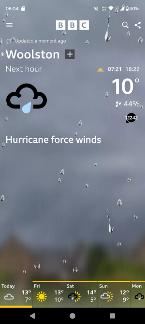
I'm really hoping that something has gone wrong with the BBC weather app today .....

1000007681.png

I don't fancy a wind speed of 12,242 mph!
 

franksingleton

Well-known member
Joined
27 Oct 2002
Messages
3,591
Location
UK when not sailing
weather.mailasail.com
Some comments on the above.

My understanding is that PWE/PWG start with ECMWF/GFS analyses on 9/13 km grids. They degrade these to 50 km grids and then run their CSIRO model. With no more observational data, they run PWE/PWG on smaller grids, 7 and 1 km. There is no way in which their models can compete with national weather service or ECMWF models. As far as I know nobody else runs a forecast model on a 50 km grid. That sounds like the early or mid 2000s. Rather than use home grown (CSIRO) model, the Australian Met service bought the UK UM and paid for Met Office staff to help instal it.

ECMWF is part owned by the Met Office along with several other countries. It was set up to develop medium range prediction. Its model is run further ahead than the Met Office, DWD or Meteo France. Why have a dog and bark yourself? All Met services work together. That is necessary in terms of forecasting development, exchange of knowledge and ideas, data and exchange of forecasts.

Because ECMWF is set up to concentrate on the medium range, it does not have immediate operational pressures such as those on national services. Therefore, it puts more resources into data analyses. It runs later than national models and only twice a day. For the next 3 or 4 days there is usually little real difference between models. The further ahead you go, the better will ECMWF perform vis a vis other models.


If you stick to models run by professional, national forecast services, it does not matter which provider you use. When I read what third party providers say about forecast models, I often wonder if they have any real understanding about NWP.

When it comes to short grid length models, remember that fine details have short lifetimes. Remember that the models are nested within global models. They may, indeed should, give better detail in the very short term. Look at the area for which they have detailed data analyses. Beyond a few hours, they may be able to show some topographical effects not shown on global models but can only do so if the global models are behaving well. A small error in overall wind direction might have a big effect on local topographic effects,
 
Last edited:

franksingleton

Well-known member
Joined
27 Oct 2002
Messages
3,591
Location
UK when not sailing
weather.mailasail.com
Use the one you like the look of ;)

I don't trust any forecast more than 3 days out, preferring to look at the synoptic chart and work things out for myself. As an example, here is today's synoptic.

Surface Pressure Charts

This week will be rubbish for the south UK. The presence of the low SW of Ireland (an old tropical storm) followed by storm Kirk, the uncertain track of which will result in conflicting models but certain of some wind and rain by the end of the week, I know to get on with inside jobs.

View attachment 183885
BUT, these charts and those at Latest Uk Forecast Charts 5 Days - Franks-Weather - The Weather Window are simply graphical descriptions of the UK UM. They can be no better.
 
Top