Uricanejack
Well-Known Member
It’s a pretty old thread now.
It may help answer some of Sandy’s questions. Or the templates might be useful.
I dredged it up because it was easier than rewriting out the old templates.
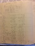
I used a lined A4 or Legal sise note book with the template when using the full long hand methods including logarithms from Norries Tables.
Or a regular sise lined note book when using a calculator.
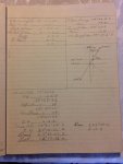
I have a shorter template some where. Or I can figure it out again. Based on the calculator method in the back of the current (2018) Nautical Almanac. I haven’t bought this years yet, I expect it’s still there.
It a bit different and more modern using Napier’s rules rather than the haversine formula. Which involves the need to decide if you will add or subtract.
It’s the same method used by the sight reduction tables on the next page at the back of the nautical almanac.
These pages were not in the almanac back in my day. So I didn’t use them myself. I did use the Napier’s rules.
I do believe Mr Burch is just using correct mathematical naming when he refers to True Latitude. Even though I haven’t read his book.
I never did use Bowditch the American Practical Navigator. ,
I have acquired a copy since I originally posted these templates. It also is available free on line. I do recommend it as possibly the best reference book available. I have not found a better one yet.
It’s a bit of a dry text book so you may find something by Cuncliff more readable.
It may help answer some of Sandy’s questions. Or the templates might be useful.
I dredged it up because it was easier than rewriting out the old templates.
I used a lined A4 or Legal sise note book with the template when using the full long hand methods including logarithms from Norries Tables.
Or a regular sise lined note book when using a calculator.
I have a shorter template some where. Or I can figure it out again. Based on the calculator method in the back of the current (2018) Nautical Almanac. I haven’t bought this years yet, I expect it’s still there.
It a bit different and more modern using Napier’s rules rather than the haversine formula. Which involves the need to decide if you will add or subtract.
It’s the same method used by the sight reduction tables on the next page at the back of the nautical almanac.
These pages were not in the almanac back in my day. So I didn’t use them myself. I did use the Napier’s rules.
I do believe Mr Burch is just using correct mathematical naming when he refers to True Latitude. Even though I haven’t read his book.
I never did use Bowditch the American Practical Navigator. ,
I have acquired a copy since I originally posted these templates. It also is available free on line. I do recommend it as possibly the best reference book available. I have not found a better one yet.
It’s a bit of a dry text book so you may find something by Cuncliff more readable.
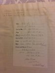
") . I note that the year was 1966. A lot has changed since then yet celestial navigation remains a very straightforward method of navigating an ocean. I'm a keen and willing amateur; here's a plotting sheet from 2020.
. I note that the year was 1966. A lot has changed since then yet celestial navigation remains a very straightforward method of navigating an ocean. I'm a keen and willing amateur; here's a plotting sheet from 2020. 