Navionics French charts

Yealm

Well-Known Member
Joined
13 Apr 2017
Messages
5,351
Visit site
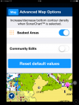
My navionics chart on the iPhone shows two different chart styles for different adjacent bits of the French coastline- one is the same as my usual UK appearance, the other I assume is a French style chart - but is confusing as none of the usual depth colours have been applied.

Example enclosed for Aberac’h.

Is there a way to get it all as UK style?

thanks ! A284BC5E-40E2-42AD-9B52-C82F3338E986.jpg
 
That area on my Android is uniformly detailed. Try downloading the shaded section again as it may not have worked properly the 1st time.
Screenshot_20171206-101549.jpg
 
I don’t have an on/off option for depth shading. I have a slider control - if I move it to zero (if that’s what you meant?) and restart the issue persists :(
 
I can reproduce that on my iPad. I think you are seeing the extreme southern boundary of the Navionics UK & Holland app. To get the detail you want south of that boundary you need to buy the Navionics Europe app.
 
I can reproduce that on my iPad. I think you are seeing the extreme southern boundary of the Navionics UK & Holland app. To get the detail you want south of that boundary you need to buy the Navionics Europe app.

It's not quite that simple. The same thing happens further south around Brest. I get a mixture of my standard UK style shading and the different french style.
 
Reproduced by turning sea bed areas on
And removed by turning off

No idea why it leaves a hard straight border makes no sense to me
 

Attachments

  • image.png
    image.png
    252.5 KB · Views: 0
Wow it worked - thanks very much !

And somehow makes the north Brittany coast look less scary :)

Reproduced by turning sea bed areas on
And removed by turning off

No idea why it leaves a hard straight border makes no sense to me
 
Top