Navionics depth offset bug they won't fix?

duncan_m

Member
Joined
20 Oct 2009
Messages
91
Visit site
I love the new features on the Navionics in particular that you can connect it to AIS on NMEA over WiFi. Great to be able to see other boats and great to see the depth, if it was correct that is.

What I've found is that the depth shown is the uncalibrated depth as passed in the NMEA sentence. For most boats this is somewhere between the waterline and the bottom of the keel/hull.

I raised a bug with Navionics last year in September when they launched the feature. What I have found was that no matter what I set the offset to in the 'my boat' section it didn't seem to adjust the depth shown. There doesn't appear to be an offset change option anymore which is good as it didn't actually make a difference.

Debugging...

The depth shown on the Navionics app is different, by 1.2m to the depth that shows on my B&G depth display + Vesper XB8000 Watchmate app, they both show the same (correct) depth.

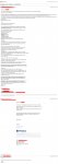
So...I did a little digging and had a look at the NMEA sentences that the Vesper is firing out..

The depth is coming through on the app as the 6.6 on the sentence but it's ignoring the -1.2 offset that's coming with it.

unnamed.png

There's also the complexity that some boats might have two sounders and there's no way to select the primary but that's another issue altogether.

I asked again 8 months later after the new AIS alarm feature 'surprised' me while moving our boat ( ) and they said the issue was 'under investigation'.

Given I've given them a more than fair chance as well as all the data here and a bit more to fix it I thought I'd raise it hear and see anyone else has the same issue?

Appreciate not everyone will be hooking up the app to their AIS...
 

duncan_m

Member
Joined
20 Oct 2009
Messages
91
Visit site
Ah yeah that's the bit I forgot to mention, obviously if you have sonar chart sharing on it's going to be pushing that data out incorrectly...
 

prv

Well-known member
Joined
29 Nov 2009
Messages
37,361
Location
Southampton
Visit site
I think the “my boat” depth setting in Navionics is meant to be about warning you where you can and can’t go, and possibly some auto-routing function, rather than to set your transducer offset. As you’ve found out, the DPT sentence contains both the raw depth and the transducer offset, so that things using it can work out depth of water or depth under keel as appropriate to their purposes.

It seems pretty clear that Navionics is ignoring the offset field of the sentence. If I had to speculate, I’d guess that the programmer writing that bit didn’t know much about boats and didn’t understand its purpose. “Depth is depth, right?”

Maybe a clear and simple bug report like “Navionics ignores ‘offset‘ field of NMEA0183 DPT sentence“ would get more traction. As a software engineer that’s the sort of thing I’m likely to cherry-pick off a work list, because it sounds nice and easy to fix.

Pete
 

prv

Well-known member
Joined
29 Nov 2009
Messages
37,361
Location
Southampton
Visit site
There's also the complexity that some boats might have two sounders and there's no way to select the primary but that's another issue altogether.

It’s also not really Navionics’s problem - remember NMEA0183 is a point-to-point serial link, not a shared bus, so its way to address that is “connect the one you want to use”. If you add some multiplexer to combine inputs (which is what the Vesper is serving as here, alongside its main role as an AIS) then it’s the multiplexer’s job to control how the output stream is assembled - which might reasonably include selecting which of two overlapping sensors it prefers to pass on. There isn‘t a standard way to pass on both and make them look like two different sources for something downstream to select between.

Pete
 

duncan_m

Member
Joined
20 Oct 2009
Messages
91
Visit site
Here's the full email thread, I'm not sure I could have been more clear.
 

Attachments

  • Mail_RE_Depth_sounder_callibration_Case_00524934.jpg
    Mail_RE_Depth_sounder_callibration_Case_00524934.jpg
    521.4 KB · Views: 8

duncan_m

Member
Joined
20 Oct 2009
Messages
91
Visit site
Yeah the multiple sounders one is a bit of an edge case. I'd have just through that there would be a simple way to correct offset in the app if they weren't going to take the one from the NMEA sentence.
 

Daverw

Well-known member
Joined
2 Nov 2016
Messages
2,927
Location
Humber
Visit site
The problem I see is that many use the offset in different ways, ie water under keel and are not interested in the actual water depth
 

Daverw

Well-known member
Joined
2 Nov 2016
Messages
2,927
Location
Humber
Visit site
So go on then, why would someone want the raw transducer depth displayed in Navionics?

Pete
Cannot answer that one, I’ve never used it within the app so never noticed the problem. I see the app for Navigation not for data display as I’ve dedicated stuff for that
 

prv

Well-known member
Joined
29 Nov 2009
Messages
37,361
Location
Southampton
Visit site
Here's the full email thread, I'm not sure I could have been more clear.

It’s certainly detailed, but you have to dig into all those words quite deeply before getting to the actual problem, the specific field in the DPT sentence which is not being read. I wonder how a non-native speaker (Navionics are in Italy) customer-service person is going to summarise all that for the ticket title - “depth doesn’t work right”, at best.

However, it sounds like they already have the bug on their list, so the point is moot.

Pete
 

prv

Well-known member
Joined
29 Nov 2009
Messages
37,361
Location
Southampton
Visit site
Cannot answer that one, I’ve never used it within the app so never noticed the problem. I see the app for Navigation not for data display as I’ve dedicated stuff for that

So you don’t actually think that Navionics using the offset to produce useful values would be a problem after all, then?

Pete
 

Daverw

Well-known member
Joined
2 Nov 2016
Messages
2,927
Location
Humber
Visit site
Not for the purpose you describe, but it then opens up a problem for sharing depth data as well for them
 

Seven Spades

Well-known member
Joined
30 Aug 2003
Messages
4,820
Location
Surrey
Visit site
If Navionics are using this incorrect depth data to create/update their Sonar charts, that is a big problem
They are I entered a lagoon in Sweden with sonar charts showing a depth of 0-0.5m, we draw 2.3m. As the lagoon is a recognised anchorage I knew the sonar charts could not be correct and have not used them since.

It is far too dangerous to use sonar charts in a word that are wrong, as they say even a stopped clock is right twice a day. My guess those who have their echo sounder set to give depth below the keel are corrupting the data.
 

Seven Spades

Well-known member
Joined
30 Aug 2003
Messages
4,820
Location
Surrey
Visit site
Yes, but how many transducers are mounted at the surface? Navionics need to know depth of transducer, we need to know distance from transducer to bottom of keel...
I wonder if they think we all use transom mounted transducers?
Exactly. The only good thing about this error is that it means that there is more water than sonar charts show.
 
Top