Navigation Apps and tablets, advice and suggestions

Chi Man

Member
Joined
9 Aug 2011
Messages
112
Location
Chichester
Visit site
Hi all,

I am looking to get a tablet/laptop to use as an updated navigational aid to my rather old raymarine chart plotter.
What tablet/laptop would you recommend within a reasonable budget of say £500
What App would you recommend, Navionics/ savvy navvy or any other?
Cruising ground would mainly be the Solent.
Thanks in anticipation
David
 

XDC

Well-known member
Joined
17 Mar 2018
Messages
1,018
Visit site
iPad has to have cellular capability.

CEX offer a 1 year warranty. https://uk.webuy.com/search?stext=iPad cellular

If it’s just for navigation a 32Gb one would be more than enough.

Navionics is perfect for the Solent and beyond.

Important to note that tablet screens are difficult to read in sunlight and you’re going to have to think about shock and water protection, plus how you charge/mount it.
 

Scarron

Active member
Joined
22 Jun 2003
Messages
595
Visit site
I have an Orca Core Orca | The Marine CoPilot - Your next chartplotter which is a N2K gateway to their own chart plotting and N2K data dashboard [£400]. I currently run it on an iPad Pro12.9" and my iPhone both of which which I already had but in due course I think I'll add their Display 2 tablet [£900].

More costly than you are budgeting but it's a really exiting product that interfaces with engine monitors, autopilots, depth, speed, wind and radar integration is on the way, all at a much lower cost than a big MFD from the major manufacturers

It's still early days for the product but they are developing it rapidly with updates and improvements almost weekly. I think it will be a major disrupter of the traditional electronics market.
 

Chi Man

Member
Joined
9 Aug 2011
Messages
112
Location
Chichester
Visit site
Thanks all, @Scarron - the Orca app looks good and have downloaded their free app on my phone to have a mess about with.
So I think I will for for a cheaper (Galaxy) tablet with cellular and GPS and then decide Orca or Navionics,
 

Parabordi

Active member
Joined
22 Apr 2011
Messages
886
Visit site
Thanks all, @Scarron - the Orca app looks good and have downloaded their free app on my phone to have a mess about with.
So I think I will for for a cheaper (Galaxy) tablet with cellular and GPS and then decide Orca or Navionics,
I would, IPADS are lousy on batteries when running Nav software and chargers seem unable to put more charge in than the unit is using, Androids are much better on Battery use. If it were me, i would look at one of these.... https://www.amazon.co.uk/gp/product/B09LC65BX6/ref=ppx_yo_dt_b_search_asin_title?ie=UTF8&psc=1
 

ChromeDome

Well-known member
Joined
25 Sep 2020
Messages
3,902
Location
Commonly in Denmark. Dizzy Too, most of the time.
Visit site
The Orca freebee is limited but that's fair.

All screens are tough on the batteries and since you'd like it to be on all the time, it's a good idea to keep it connected.

I use a Galaxy TAB 7 FE with a 12.4" screen. Great for the job, powered at all times.
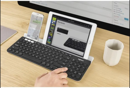
I do have a keyboard 'n stand (as not to use any part of the screen for keyboard etc.) which is multi (3) device and can be used for e.g. a phone and pc also.
1685615460530.png
 

Dino

Well-known member
Joined
27 Apr 2009
Messages
1,006
Location
Ireland
Visit site
I use Navionics on a Wi-Fi iPad with a Garmin Glo 2 Bluetooth GPS receiver. Never had an issue with sun as I have a canopy on the back deck.
I have had problems with the USB charging not keeping up with the iPad battery usage so I have installed a Scanstrut fast USB C charger.
 

Twyfordbridge

Member
Joined
29 May 2019
Messages
32
Visit site
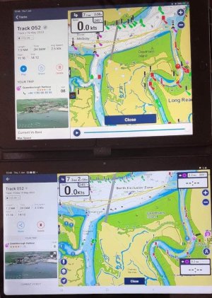
786FB2CE-1D62-43AA-80AF-48A4061B3EE7.jpeg On my iPad (top photo) you have facility to play back the track. Push play and the red pin moves along the yellow track showing your ever changing speed and direction along the route in the box, top left of screen. On my Android tablet and phone you don’t have that playback facility, just the static yellow route line. (Unless I’ve messed with some settings unknowingly....again)
 

Scarron

Active member
Joined
22 Jun 2003
Messages
595
Visit site
One of the advantages with Orca is that the Core has a GPS receiver and electronic Compass built into it in order that it can feed that data over the N2k and WiFi networks to connected devices. Therefore your connected tablets or phones don't need to run the GPS for charting or heading functionality thus reducing the battery draw.

It also shares any internet connection it finds and uses that for acquiring AIS, wind, tides and weather inputs to its charting.

That being said, as well as the Orca charting app I also have Navionics + C-Map + Imray charting apps installed on the iPad and will often run them in parallel as the charting and functionality of each varies, they do each have different strengths and weaknesses.

Early days for me at the moment and I am only connected to the Orca core for GPS and Compass, but the next phase is to start building an N2k network of sensors. On my list is depth, magnetic speed log, fuel flow, rudder position, tank levels and later on adding an auto-pilot and maybe Radar over Wi-Fi. You can run multiple screens so could build a glass bridge to display charting, radar, instruments etc. My boat has a pair of mechanical Ford Sabre diesels and by using an Albacombi analogue to N2k converter I should be able to bring in all of my analogue engine info, temps, pressures, revs, etc. There are already N2k engine gateways available for many engines.

With regard to iPad charging I use one of these and it easily keeps up with battery drain USB-C charger

The only drawbacks so far are screen brightness in an open cockpit on the iPad, which is reputedly solved with the Orca Display 2 and the fact that it is in development so can be buggy, they are working pretty hard at it and have an active Facebook community providing lots of input, criticism and encouragement.
 

Hurricane

Well-known member
Joined
11 Nov 2005
Messages
9,586
Location
Sant Carles de la Ràpita
Visit site
I have a Galaxy Tab S and a Galaxy S23 phone.
Both run OpenCPN well but I prefer a "proper" computer so I would be suggesting a good laptop instead of a tablet.
Again, OpenCPN (free for the Laptop) runs under Windows.
I use OpenCPN as a second plotter on the boat using the ships PC which is integrated into the nav system.
Whilst cruising, I have the option of Navionics under Raymaring or OpenCPN from the PC.
And I DO use both all the time - if anything OpenCPN gets more use.

It is easier to feed AIS into a proper PC and OpenCPN handles AIS better than anything else on the market.
 

oldgit

Well-known member
Joined
6 Nov 2001
Messages
28,261
Location
Medway
Visit site
If you already have newish Ipad which can handle the latest Navionics its no brainer to just use it and also download the free App to make it communicate with a Raymarine chartplotter with WiFi capability
If buying new the Apple makes no economic sense at all when Android tablets costing a fraction of the price are on the market.
My ancient 10" Ipad with Navionics certainly did the job, but after replacing 2 screens, problems keeping it charged , sunlight issues and its tendency to shut down when warm and finally not being able to download the latest version of Navionics software, its now going to be an Android tablet.
 

Hurricane

Well-known member
Joined
11 Nov 2005
Messages
9,586
Location
Sant Carles de la Ràpita
Visit site
Android
Just be aware that Google have changed their Android policies since Android 11.
It seems that they are trying to "lock it down" in a similar way that Apple do on all iThings.

The biggest change is storage.
Google/Android now don't allow an application to store data in any folder of the device - specifically external microSD cards.
But also any ad hoc directory in the system memory (strangely called sd memory).
They now expect that all apps store their data within the individual app's application directory which is difficult to find.
Data like music, videos and photos etc use the Android Media Library which is generated from data within ad hoc directories so the average user won't see any difference.
All apps have access to the Android Media Library.
But chart files will not be included in the Medial Library so the authors of the charting software will need to store their charts within the apps dedicated directory.

However, Google have licensed/allow access for some applications to work on directories outside the application directory but they are limiting that to specific File Explorers etc.
BTW, a good file explorer that I use is Xplore but the device manufacturers usually supply their own file explorers with their devices.

I have written my own photograph browser that uses ad hoc directories outside the app directory and I get the Media Library to ignore them so that they don't appear in the Gallery.
This way, I keep all my photographs (58,000 of them) on the phone without the Gallery seeing them.
In order for my app to see my photos, I found a method of "tunneling" through these latest Android restrictions so that my photo app can get at my photos.
I have just upgraded my phone to Android 13 and expected my "tunnel" to fail but it is actually still working.
But for how long????

This may all be mumbo jumbo to most of you but the OpenCPN team have found it a real PIA.
Navionics will have the same issue but they have never published the location of their charts so these changes might be seemless to the average user.
The latest version of OpenCPN's Android software has a built in migration module that imports charts from ad hoc directories into the OpenCPN app directory.

We are all expecting Google to do more of this stuff in the future and lock it down even further.

That said, Android is WAY better than IOS which absolutely locks you down.
It is just that we are starting to loose the nice flexible Android device that we all know and love.

Just thought I would make this point - I still use and like Android.
 

Chi Man

Member
Joined
9 Aug 2011
Messages
112
Location
Chichester
Visit site
Okay thanks everybody, your opinions have really helped me decide as there is so much out there it can be very confusing, but to receive advice from other forum members is invaluable (the YBW forum can be a real asset).
Decision made, I have ordered the Oukitel tablet and will download Navionics.
 

franksingleton

Well-known member
Joined
27 Oct 2002
Messages
3,630
Location
UK when not sailing
weather.mailasail.com
It depends on what other equipment you have.
We have wireless hotspot for our GPS/AIS.That means that we can use a tablet That does not have cellular connection. We have used to Nav apps, iNacX and iSailor. On balance, we prefer the latter.
On Channel crossings, we plug the iPad into the 12vdc supply.
 
Top