Wansworth
Well-Known Member
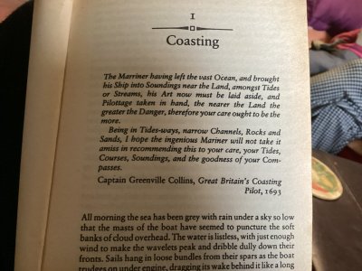
Great Britain’s Coasting Pilot….Captain Greenville Collin’s…..published 1693. Charles 2commissioned Collin’s as hydrographer and sorted him out a yacht and sent him on a Severn year study of the British coastline
Have you bought a copy? Sounds interesting.Great Britain’s Coasting Pilot….Captain Greenville Collin’s…..published 1693. Charles 2commissioned Collin’s as hydrographer and sorted him out a yacht and sent him on a Severn year study of the British coastline
No but would love to see one!Have you bought a copy? Sounds interesting.
No but would love to see one!
IfI was doing around Britain’s would buy it without doubt…..probably not much changed except for sandbanks and nuclear power station conspicYours for just £191!
Great Britain's Coasting Pilot : Captain Greenville Collins : Sailing
You can view some of the maps - and its fantastic frontispiece (we should have this sort of thing in our Imray and Reeds etc. publications today!) - here:
Charts by Captain Greenville Collins
More about the chap himself -
Greenvile Collins - Wikipedia
The Lost Journal of Captain Greenvile Collins, Part 1
I was hoping to perhaps find the text of his coasting pilot on e.g. the Gutenberg or similar website, but haven't done so yet, and have more pressing things to do just now.

On leaving Belgian. Waters the pilot handed the skipper a weather forecast showing Belgium straight along the bottom of the page withtheUK ata most odd positionI always find it curious that these earlier cartographers rarly followed the now universal convention of N Up, at least here in Europe. Sometimes gives quite an interesting perspective to see things E or W up!
I always find it curious that these earlier cartographers rarly followed the now universal convention of N Up, at least here in Europe. Sometimes gives quite an interesting perspective to see things E or W up!
That was typical of all illustration. Medical ones, too, I believe. Focus was on what the author was discussing.Early European sea charts were not to scale, apparently. Bits of the coast of interest - harbours, river mouths, areas of hazards, notable landmarks etc. - were drawn larger, and long straight boring bits of coast, for instance, were drawn smaller. The exact bearings and distances between locations wasn't important, but being able to pilot themselves around hazards, and into port, was.