Local Historical Curiosity

Dave 71

Well-Known Member
Joined
26 Mar 2021
Messages
125
Visit site
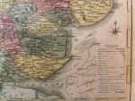
A few years ago, my wife bought me an antique map of Essex. It dates from around 1800, and was published in what I believe was a tourist guide book to the area in 1801. Interestingly, it includes a little nautical detail that might be familiar-ish, although very basic compared to the modern buoyage, a Whitaker Beacon at the eastern end of Foulness Sands, some depths in the main Thames estuary and what appears to be a 'deep' channel across the Ray Sand. Of course, I have no idea where the original artist/cartographer obtained that information or how accurate it would have been even then, but I wonder if there ever was a route north from the Crouch closer in shore, now silted up.
 

Attachments

  • map3.jpg
    map3.jpg
    81 KB · Views: 79
If dated around 1800, the maritime details are pretty inaccurate, I'm afraid. At the beginning of the 1800's, one of the best surveys in the area had been conducted by Graham Spense who famously navigated Nelson in HMS Medusa from Harwich to the Nore (in 1801) when the defence plans to hinder Napoleon were being made.

It is interesting that the Knoll was drawn much larger hence the 'north passage'. The Knoll is quite small today in comparison and the 'north passage' is possibly, just, about still there as the best water from the Ray Sand to the Blackwater follows the 1 degree E meridian today. One may speculate about that area over the last 2000 years. There is some (thin) evidence that Othona, the Roman Fort at Bradwell might have been a naval base and given that Othona guarded the shores, one could argue that Othona was located to guard both the Blackwater and the Crouch if the seaward approaches were clearer than in 1800. Othona was one of the 'Saxon' forts i.e to make sure we didn't land! The Buxey probably didn't exist in Roman times.

The land part of the map is interesting. Note the extensive 'marshy' land east of Burnham. In medieval times, the land was extended for a couple of miles to the east for cultivation.
 
Yes, I thought it would be pretty inaccurate and that even proper charts of the time would include a lot of 'educated guesswork'. Seems to have a broad correlation to the main features today, and I had read something similar about the Roman fort, so I wondered if there was once a deeper in shore route. The main part of the Roman fort is (I think) to the east of the church, outside the line of the seawall, and I read somewhere that there was once a sizable Saxon town/trading port in the area, lost to the sea some time before the Norman conquest, so I would imagine it has changed a lot over the centuries.
 
Yes, the Roman fort was east of the church; I seem to recall the back wall was in line with the now seawall but I ought to dig out the book and read it again. It is said all the Saxon forts had mobile (i.e. horse) squads to follow shipping down the coast to discourage. But a couple might be naval bases.

Of course the area has greatly changed: the River Blackwater isn't a River for example. It is a Ria i.e. a drowned river valley. Hence no proper bar?
I wasn’t aware that rias were less prone to bars. It doesn’t seem to work for Salcombe.
 
Hence the '?' I had read it somewhere before but couldn't find it. It might have been something to do with the Blackwater being relatively 'drowned' compared with Devon estuaries. The Orwell and Stour are recently formed as well. I will see if I can find it later.
 
I have oft seen it writ, and I'm sure I recall seeing old charts somewhere that so indicated, that in centuries past the approach to the Crouch for shipping was the Ray Sand channel

I do know that the understanding of ancient coastlines and watercourses is changing dramatically with every new study and investigation

Relatively recent innovations such as Lidar and ground penetrating radar plus incredibly detailed modern sea bed scans are producing evidence of quite frequent and often dramatic change due to environmental factors, the activities of man or both

The Roman fort of Othona was, for example, still extant as a substantial ruin as recently as the 17th century. In the subsequent 400 years or so, it has been almost entirely lost to coastal erosion. The only physical evidence of its existence is recycled Roman building materials in the walls of St Peter on the Wall. What little is known about the fort itself comes from the writings of medieval historians and Victorian antiquarians (whose writings and conclusions have always to be taken with a large pinch of salt)
 
Especially if it related to ancient Britons, Druids or similar!

Especially anything related to "druids"!

A great deal of nonsense was written by 19th century antiquarians et al about ancient religions and they largely created modern neo-paganism from scratch*

In reality we know very little about pre-Christian British religious beliefs and practices, what little evidence we have is largely from Roman writers and problematic as much if not all of it may be fabricated for propaganda purposes

* For those not in the know, I am (or to be more precise consider myself to be) a Bard in the Celtic tradition however I don't align myself with modern neo-pagan groups (thus earning the modern and somewhat derogatory prefix "hedge" as in "hedge druid", "hedge witch" etc)
This guy (William Price (physician) - Wikipedia) has a lot to answer for! But Stukely and Aubrey started the ball rolling.
 
  • Like
Reactions: Bru

Other threads that may be of interest

Top