How far from land before your offshore vs coastal sailing?

ColourfulOwl

Member
Joined
10 Sep 2022
Messages
53
Location
Fleetwood Beacon Marina
www.colourfulowl.com
I was having a conversation with someone today about my plans to visit the Isle of Man for my birthday week in August. My boat is currently in Fleetwood. They asked if that journey would be my first time 'offshore' sailing.

I personally would of classified this as coastal, but It kind of raised the question of, what do you actually classify as Offshore? How far from land do you need to actually be, to be offshore?

With the route that I'll likely take (weather depending - it might make more sense to go south of the windfarm), the furthest away from land I'll be at any one time is about 16nm.
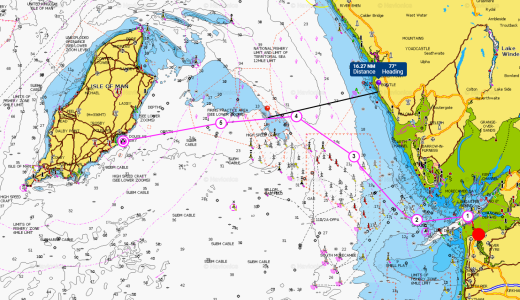
fleet-iom.png

Interested in hearing peoples thoughts on this :)
 

Daydream believer

Well-known member
Joined
6 Oct 2012
Messages
20,951
Location
Southminster, essex
Visit site
Well at 16 M you will be in sight of any high land so I would not call that offshore.
Perhaps 24 hours from any port of refuge & out of sight of land might be classed as offshore
.
Good luck with the trip by the way. It will be fun however far you go. I find that apart from the sailing it is the planning,- probably the best bit-- the departure & the arrival that gives one the thrill & the memories.
Based on hoping for SW winds I would head west to clear the south end of the farm then have a reach all the way. Same would work for easterlies & avoid rough water over the shallows north of the farm ( If there could be) There is a firing area shown so that may be an issue as well.
 
Last edited:

Davy_S

Well-known member
Joined
31 Jan 2003
Messages
10,971
Location
in limbo at the mo.
Visit site
Having sailed from Fleetwood to Douglas many times, i would suggest your route looks strange, it is around 52 nautical miles from the Fairway buoy to Douglas, you would leave Fleetwood just after high water so to catch the ebb out towards the Lune deep, lets just imagine you average 5 kn, and you aim for Douglas, you will more than likely be swept South then North as the tide floods ending up at Douglas, so your curve will be opposite the one you have plotted, the ferries actually go straight through the windfarms, personally i would go South of the windfarms, when you pass Shell Wharf you will be drifting South with the tide anyway, keep away from the rigs because the security RIB will head your way to check you out!
enjoy your trip which ever way you do it.:)
 

Tranona

Well-known member
Joined
10 Nov 2007
Messages
42,329
Visit site
Like many of these terms it is a social construct so means whatever the person or body which uses it intends it to mean. so we have 3 constructs here already - in relation to land, in relation to a safe haven and greater than a specific distance safe harbour. Add to that the definition for the RCD categories where the major determinant is the size of waves one is likely to encounter, which in turn determines design parameters for the boat.

No doubt there are others but it is only a label the meaning of which is shared by those that are using it in a specific situation - a sort of shorthand.

Enjoy the trip - it is much the same distance as Poole Cherbourg with similar challenges of a cross tide and a good full day's sail. A right of passage rather like the 25 miles by bike from Romford to Southend when I was a kid.
 

ColourfulOwl

Member
Joined
10 Sep 2022
Messages
53
Location
Fleetwood Beacon Marina
www.colourfulowl.com
Well at 16 M you will be in sight of any high land so I would not call that offshore.
Perhaps 24 hours from any port of refuge & out of sight of land might be classed as offshore
.
Good luck with the trip by the way. It will be fun however far you go. I find that apart from the sailing it is the planning,- probably the best bit-- the departure & the arrival that gives one the thrill & the memories.
Based on hoping for SW winds I would head west to clear the south end of the farm then have a reach all the way. Same would work for easterlies & avoid rough water over the shallows north of the farm ( If there could be) There is a firing area shown so that may be an issue as well.
Thank you. It'll be my longest passage/trip on my own boat. It sort of a trail run and an early shake down for my long term plans.

Having sailed from Fleetwood to Douglas many times, i would suggest your route looks strange, it is around 52 nautical miles from the Fairway buoy to Douglas, you would leave Fleetwood just after high water so to catch the ebb out towards the Lune deep, lets just imagine you average 5 kn, and you aim for Douglas, you will more than likely be swept South then North as the tide floods ending up at Douglas, so your curve will be opposite the one you have plotted, the ferries actually go straight through the windfarms, personally i would go South of the windfarms, when you pass Shell Wharf you will be drifting South with the tide anyway, keep away from the rigs because the security RIB will head your way to check you out!
enjoy your trip which ever way you do it.:)
Interesting. I haven't properly planned out the isle of man trip. Mostly been thinking about what I'll be doing in 2026. I plan to do a circumnavigation of Britian, starting in April. The isle of man trip this year is a bit of a trail run of longer term liveaboarding outside of the home marina etc. I'll likely end up doing angelsey in 2025, which is where I did my course.

It is Intresting though about the whole north/ south of the wind farm. I often use both savvy navvy and Navionics to pre plan. Savvy takes into account tide, wind etc to create a sailing plan, even outlining where to tack, gybe, reef etc. The few times I've headed to Piel Island, I've always ended up making it up, to play around, rather then following the app.

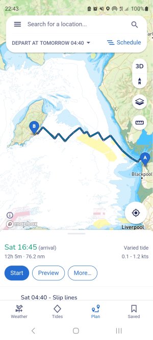
If I was to leave at the next high water, 4:40 tomorrow, Savvy actually says go to the North.

Screenshot_20240202_224354_savvy navvy.jpg

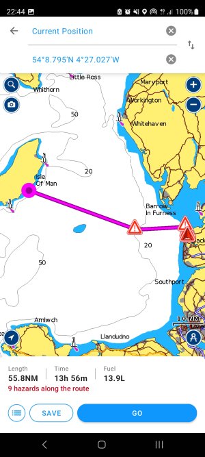
Where navionics auto routing says the south.

Screenshot_20240202_224458_Boating.jpg
 

Daydream believer

Well-known member
Joined
6 Oct 2012
Messages
20,951
Location
Southminster, essex
Visit site
Personally- & this is only a personal opinion which will be shot down by many i am sure- I think that you are going about the passage plan all wrong.

This is, I believe, your first long trip & it is probably in the region of 60 miles. I do not have a chart or tide tables to hand so I cannot comment with accuracy on that aspect. However, It may be a big trip for you & an excellent learning curve. If I have this wrong then please accept my apologies for making such assumptions. But my comments may be of use to others.
First thing is to stop gawping at savvy navy & other app gimmicks . Put the Iphone, ipad etc away & get a decent chart & a copy of Reeds, if you intend to sail the area . You have plenty of time so can study the chart & prepare several plans. I suggest a route south of the wind farm & you have to make assumptions. ie it will not be blown out due to strong winds, the wind will be favourable, you will be able to depart over a 3 day (or whatever) window & return in a similar time frame. Remember one has to get home so passage plans can be a 2 way affair.
Then get some transparent paper & clip it to the chart & plot a course showing tidal offsets etc every hour based on your average speed. The journey is a milk run, because for much of it you have a dirty great wind farm on your stbd side to guide you. You will be able to see it up to 5 miles away with relative ease. Plot a course for the last IALA buoyon the western tip. You need to get within 1.5 miles of it to be sure of finding it. If you think you have missed it, then by all means revert to the Ipad for a position check. But then put it away. To be honest you should have a job to miss it as it is close to the end of the wind farm.
That would give you an excellent spring board for the IOM which should be as large as life in front of you. Certainly within a couple of hours.

Whatever you do keep looking behind you & take a mental picture of the wind farm. First because it will give you a bearing, so you know how you are doing against your course.
draw a bearing line on the chart as quick course reference to check your tidal offset. You do not necessarily need a hand bearing compass. However, one is always handy. One can normally guess the angle by sighting over the compass- You do have a decent one I assume?

Second & just as important- You know what you are looking for when you return. You have to be a bit more accurate on the return, as a buoy is harder to find than a mountain!!!. I have a couple of clearing bearings on my chart of the Thames estuary from things like the transformer tower in the windfarm, which I still refer to & I have been sailing there for years
Just draw a pencil line from the edge of the wind farm along your proposed route.

Your plan & tidal offsets should get you arriving at Douglas, up tide of your target & once 4-5 miles away you can turn on the Ipad for the final run in. If it is dark then use the lights on shore & follow those which is much more fun & keeps you on your toes.

Assuming that your average is 4kts do a plan for 3, 4 & 5 kts & you can overlay each one on the chart if speed changes during the trip. You only need to worry about leeway when upwind because on a reach you will be luffing on waves & wind gusts & possibly sailing above your course. You can turn on the GPS for a few minutes to check your course against that to see if you are doing what you think. However, having gone past the wind farm you will have an idea of how well you are holding your intended angle.

Over the last 20 miles, of which 15 will be the guess work, tide will not be a massive difference unless tides are strong in that area (I have no experience of that) I have a sheet that I write down a pictorial analysis of the tides so I can see at a glance what they are doing & make mental notes of course adjustment if I think I am off course. I will post a picture if you ask.

The point of all this is that navigation can be as much fun as sailing the boat & it gives one confidence of where one is. I regularly sail between Lowestoft & the Channel Islands with very little use of the chart plotter, only having it on for the AIS function & in shipping areas.

Just sailing A-B can be boring, arriving at the right place can be rewarding. I have arrived at the wrong place a couple of times. But my crew once said said that they viewed the surprise destination a bit like getting an extra Xmas prezzie
 

Davy_S

Well-known member
Joined
31 Jan 2003
Messages
10,971
Location
in limbo at the mo.
Visit site
Regarding tides in the area, on big tides 9mtrs, the stream can reach 3.5 knots in the lune deeps, also bear in mind that any wind from the South west will cause big swells in the deeps when an ebbing tide is running, if there is plenty of S/W wind, the deeps can be very dangerous! forget about sailing for a minute, if you plot a course at 5knots from King Scar to Douglas just after high water and set off on the direct compass course, you will go in a curve to the South then as the tide starts to flood it will take you North, you will spot the IOM if the weather is clear enough, sometimes you will not see the IOM until you are less than 10 miles off. the yacht club in Douglas used to be very good, not been for years now.
 

Graham376

Well-known member
Joined
15 Apr 2018
Messages
7,766
Location
Boat on Mooring off Faro, Home near Abergele
Visit site
The inshore forecast is for waters upto 12nm from land so possibly anything over 12nm.

Suggest OP asks his/her insurers. With our first two boats based in Conwy, Isle of Man was not covered under our UK coastal waters policies and had to be added with endorsement. The 12 mile limit is usually measured from headlands, allowing greater distance from shore when crossing a bay.
 

dansaskip

Well-known member
Joined
12 Nov 2004
Messages
658
Location
Various
seabear.uk
Daydream believer makes some very good points, particularly about navigation apps. There is an old saying "That no plans survive contact with the enemy" or substitute reality for enemy. In the case o sailing it is the wind and weather. The trouble with that Savvy Navy track is that it tries to be too precise, tries to tell you were and when to tack and if you tried to follow it too religiously you might well come unstuck. Over the course of a 60 mile trip which might take around say 15hrs all sorts of things, wind and weather included may well change. So I reckon one must keep a certain flexibility in one plans and be prepared to change them depending on circumstance. On a passage like that you are mainly across tides so you will be swept roughly n for 6 hrs then back roughly s for 6 hrs so as long as the tide isn't sweeping you onto some danger it is not a problem. Just needs reckoning with for departure and landfall, you don't want to be up tide of Douglas on approach and have to fight the tide. S invest in a tidal atlas if you haven't one and a paper chart and study well. I find it useful to pencil in the times for the day in question on each page of a tidal atlas so at a once you can see what is going on. Enjoy the trip and the Isle of Man I love the place.
 

Davy_S

Well-known member
Joined
31 Jan 2003
Messages
10,971
Location
in limbo at the mo.
Visit site
On a passage like that you are mainly across tides so you will be swept roughly n for 6 hrs then back roughly s for 6 hrs

dansaskip

can i point out that you have that the wrong way, ie he will be swept SOUTH for six hours, then NORTH.
not trying to be arsey, just pointing it out,:)
 

Davy_S

Well-known member
Joined
31 Jan 2003
Messages
10,971
Location
in limbo at the mo.
Visit site
Don't forget the Kraken!
19dea32a-8657-4dbd-95cc-9c06cf262d10_16-9-aspect-ratio_default_0.jpg
 

Supertramp

Well-known member
Joined
18 Jul 2020
Messages
1,022
Location
Halifax
Visit site
Lots of useful comments from others.

I sail these waters and whether they are coastal or offshore is not the issue. More of a challenge is strong tides, lack of shelter and some (un)reasonable seas when the wind doesn't agree with the tide. That is not to scare, but good weather planning and contingencies would be in my passage plan. What will I do if my average is 4.5 rather than 5 knts? What will I do if the wind is 25knts instead of 20? Where can I shelter if I miss the tide into Douglas? Or get caught in adverse tide? Which part of the trip is most time critical (daylight port entry, tidal gates)?

I would also plan on paper. Its too easy to miss the details when popping waypoints into a plotter or laptop. There are good pilot guides on the area.

The upside is that the area offers most the challenges you will meet on a trip around our coasts and there are some great areas to explore. There is a lot of satisfaction from making a crossing rather than a coastal hop. Do let this thread know how it goes.
 

dansaskip

Well-known member
Joined
12 Nov 2004
Messages
658
Location
Various
seabear.uk
can i point out that you have that the wrong way, ie he will be swept SOUTH for six hours, then NORTH.
not trying to be arsey, just pointing it out,:)
No point taken if he leaves around HW. I'll check more carefully in future. Since switching from Irish Sea sailing to East coast I have got used to the ebb in general flowing north
 

RupertW

Well-known member
Joined
20 Mar 2002
Messages
10,266
Location
Greenwich
Visit site
I don’t understand the planning on paper comments at all. I like to have paper charts around and tend to put positions on them on longer passages but planning is so much easier and I think better using my iPad.
 

Graham376

Well-known member
Joined
15 Apr 2018
Messages
7,766
Location
Boat on Mooring off Faro, Home near Abergele
Visit site
I don’t understand the planning on paper comments at all. I like to have paper charts around and tend to put positions on them on longer passages but planning is so much easier and I think better using my iPad.
Maybe you haven't done any sailing in the Irish Sea around Isle of Man? Boats with small engines may not be able to stem spring tides in some areas and calcs much easier and most likely more accurate on chart.
 
Top