You are using an out of date browser. It may not display this or other websites correctly.
You should upgrade or use an alternative browser.
You should upgrade or use an alternative browser.
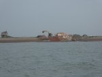
Farewell old friend
- Thread starter James W
- Start date
Tomahawk
Well-Known Member
Ah yes... the much vaunted Envronment Agency at their most bloody stupid.
They can’t afford to do anything about a lighthouse...
But spend millions defending a strip of land about 500 yards wide and half a mile long at Brightlingsea.. Half the land being defended is in set aside and it only produces subsidised crops so a double stupidity.
They can’t afford to do anything about a lighthouse...
But spend millions defending a strip of land about 500 yards wide and half a mile long at Brightlingsea.. Half the land being defended is in set aside and it only produces subsidised crops so a double stupidity.
Bru
Well-Known Member
I can't comment on the stupidity or otherwise of the sea defence works at Brightlingsea but it would certainly be stupid to spend public money on a redundant lighthouse of no great historical or architectural significance that is built on a shingle beach subject to erosion and drift
It's sad to see a local landmark demolished but there was no practical or sensible alternative
It's sad to see a local landmark demolished but there was no practical or sensible alternative
MikeBz
Well-Known Member
Ah yes... the much vaunted Envronment Agency at their most bloody stupid.
They can’t afford to do anything about a lighthouse...
But spend millions defending a strip of land about 500 yards wide and half a mile long at Brightlingsea.. Half the land being defended is in set aside and it only produces subsidised crops so a double stupidity.
Defending that seawall is not stupid. If the seawall they are repairing is allowed to breach then a considerable length of the 'hump' going inland which forms the Great Divide would need to be reinforced instead, otherwise the lower end of the Manor estate, Lower Park Road etc. would be in danger. Not to mention the loss of the walk around the old Railway Line to Alresford Creek which is enjoyed by a great number of people. It's also used for grazing sheep.
The money would be better spent doing something about a disused privately-owned lighthouse which is going to fall into the sea?
Tomahawk
Well-Known Member
Looking at google maps... and from walking the path from B,sea to Wivenhoe, it would only take about 400m of defence to protect the road onto the island. And that 400m would be in an area where there are no waves to errode the sea defence.
Besides that the sea wall is destroying the salt marsh because it doesn’t allow the marsh to move dynamically with the weather and reflect changes to sea levels.
Besides that the sea wall is destroying the salt marsh because it doesn’t allow the marsh to move dynamically with the weather and reflect changes to sea levels.
WoodyP
Well-Known Member
The EA have to abide by cost benefit and affordability to preserve people and businesses from flooding. Coastal erosion is the responsibility of the local authorities. I think that you have the wrong target, but the LA have similar guidance to abide by and make the best use of scarce resources.Ah yes... the much vaunted Envronment Agency at their most bloody stupid.
They can’t afford to do anything about a lighthouse...
But spend millions defending a strip of land about 500 yards wide and half a mile long at Brightlingsea.. Half the land being defended is in set aside and it only produces subsidised crops so a double stupidity.
Tomahawk
Well-Known Member
The sign on the footpath was the EA.. not Tendring DC.
In terms of cost benefit... The sea wall is 5km long form the tide mill to the flood cell split next to the sewage farm. Work out the cost of biulding that sea wall at 20 CuM per linear meter of wall minimum of London clay placed and compacted to flood safe standard with tem passes of a vibrating roller every 150mm of material? To protect a a strip of land that is only some 300m wide before the land rises to above the top of the sea wall.
In terms of cost benefit... The sea wall is 5km long form the tide mill to the flood cell split next to the sewage farm. Work out the cost of biulding that sea wall at 20 CuM per linear meter of wall minimum of London clay placed and compacted to flood safe standard with tem passes of a vibrating roller every 150mm of material? To protect a a strip of land that is only some 300m wide before the land rises to above the top of the sea wall.
Last edited:
Leighb
Well-Known Member
DavidofMersea
Well-Known Member
I think you will find that B'sea is not an islandLooking at google maps... and from walking the path from B,sea to Wivenhoe, it would only take about 400m of defence to protect the road onto the island.
Tomahawk
Well-Known Member
It will be when global warming melts the glaciers.
Dan Tribe
Well-Known Member
Somewhere, I have an old geological survey map which, almost, disagrees with that. It shows Flag Creek just about connecting with Alresford Creek. Jack Cootes Vol 1, 1956 seems to nearly agree. You could maybe have done the passage in a canoe, portaging across the B1029.I think you will find that B'sea is not an island
Tomahawk
Well-Known Member
Indeed, when you drive across the bottom of the valley past Gatehouse Farm you are below the top of the seawall along Arlesford Creek. But for the wall you would be swimming on spring tide.