AIS Tracking

Chris CJ

Active member
Joined
30 Nov 2020
Messages
118
Visit site
I like to review my AIS track after a days sail , normally I follow this on Vessel Finder ( free service ) recently this has been giving an incomplete track. Thought this is an issue with my AIS kit , checked all the connections , all appears to be ok , with 2 green lights showing the kit is working correctly. To double check I’ve used Marine Traffic ( free service) this shows a complete track.
Is this a case of getting you to pay for a service or do I have a problem
I’d be pleased to hear your thoughts on this
Chris
 

Martin_J

Well-known member
Joined
19 Apr 2006
Messages
4,405
Location
Portsmouth, UK
Visit site
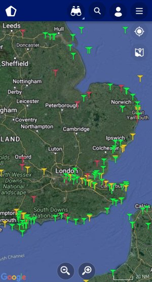
They both rely on amateur land based 'receiving stations' whereby people living near the sea (or lakes/rivers/canals) can set up an AIS receiver and upload all the AIS info it hears to the service provider (e.g. MarineTraffic or Vesselfinder) who can then make that received information avaliable on either their website, app.

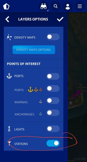
I know on MarineTraffic you can display the receiving stations on their map.. and you can see which receiving station your position is being relayed through. I would expect you to be able to see the location of receiving stations on Vesselfinder as well.
 

Martin_J

Well-known member
Joined
19 Apr 2006
Messages
4,405
Location
Portsmouth, UK
Visit site
With that in mind... There is likely to be somebody (or a number of people) signed up to Marinetraffic who have set up receiving stations within range of your track.

Perhaps Vesselfinder just don't have anyone signed up as a receiving station within range of where you were sailing, or their receiving kit is offline or just not receiving as well as it did.

Take a look at both services and see if you can work out where their receiving stations are in that area.
 

wonkywinch

Well-known member
Joined
30 Jul 2018
Messages
2,031
Location
Hamble, UK
Visit site
Do you have a chart plotter or GPS tracker app on your phone onboard that you can download your track to some mapping/charting software?.
Or a smart phone with the Navionics Boating app, or Strava or one of many other track apps.

Edited to add Memory Map to the options.
 
Last edited:

Chris CJ

Active member
Joined
30 Nov 2020
Messages
118
Visit site
Both vessel finder and marine traffic have shown our full track today from Ushant to Cameret ( to shelter from some strong s/w winds forecast over the next couple of days .) Interesting how basic these tracking systems are set up , not a professionally as I had previously thought.
 

jbweston

Well-known member
Joined
25 Jun 2005
Messages
845
Location
Me: Ashby-de-la-Zouch. Boat: The Clyde
Visit site
As previous replies have said, whether you'll appear on this kind of app depends on whether you (that is your boat) is in range of a shore station that's (a) working and (b) feeding into that particular app's/website's service. It's common for the tracking not to work when, for example, you're well offshore.

If you want to check your AIS just call a friend's boat that's AIS receiver-equipped in range of your AIS and ask if they've got you on their display. Or you can call National Coastwatch if there's a station nearby as they are very helpful.
 

Chris CJ

Active member
Joined
30 Nov 2020
Messages
118
Visit site
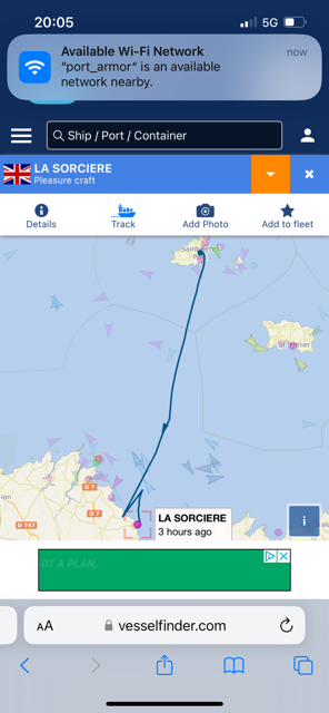
Thanks for all your comments , we had another interesting experience the other day where the track suddenly altered putting us on the beach and then correcting itself , as shown belowIMG_9119.png
 

wonkywinch

Well-known member
Joined
30 Jul 2018
Messages
2,031
Location
Hamble, UK
Visit site
Thanks for all your comments , we had another interesting experience the other day where the track suddenly altered putting us on the beach and then correcting itself , as shown belowView attachment 178431
I see this all the time, I think you just have to accept the limitations of the web based AIS trackers. The level of accuracy you see is directly proportional to how much you are paying for the service.

If you want accurate tracks of your own voyages, you're going to have to record them yourselves then overlay your gpx file on Google maps etc.

Relying on AIS pings interpreted by amateur receivers feeding a free service on the internet is a different type of data than your own HPS derived track with many more points of data saved.
 
Top