tillergirl
Well-known member
UKHO Permanent/Preliminary/Temporary Notices:
1. New Editions of ADMIRALTY Charts to be published on 23rd May, 2024 - Chart 1534 - International Chart series, England - East Coast, Great Yarmouth and Approaches. 1:25,000; A Great Yarmouth Outer Harbour. 1:7,500; B Great Yarmouth Haven. 1:7,500
Chart 1535 - International Chart series, England - East Coast, Lowestoft and Approaches. 1:25,000; Lowestoft Harbour. 1:6,250
Includes changes to depths from the latest British Government, Trinity House and Great Yarmouth Port Authority surveys.
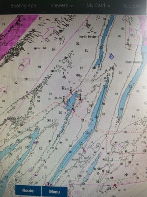
2. NORTH SEA - Netherlands Sector - Buoyage. - This notice announces a family of four cardinal buoys (one each) marking the site of the ‘soon to come’ Princess Elisabeth Island. This is located west of the Westhinder bank and east of the NE going TSS. NtM 783 placed two yellow special buoys earlier this year in the same location. The Belgium plan is from the ELIA group and the oject is to create an energy hub which will connect UK, Belgium and Norway. I have linked a brochure with the usual pdf image download. The island is to be built from now to mid 2026 and then the energy hub will be built. The location is probably unlikely to hinder leisure craft given that crossing over the Westhinder bank is best avoided.
3. ENGLAND - East Coast - Obstructions. - This notice is probably the product of the detailed survey that the Northern Wind undertook at the end of last year. Two new obstructions off Clacton and Frinton. Both in plenty of water for us so unlikely to hinder leisure craft – but of course might be a good lobster pot place! Traditionally pots in this area are poorly marked by some!
4. ENGLAND - East Coast - Depths. Drying height. - This notice has 13 reductions of depth of which one is a drying height but all are located close in the commercial area alongside the jetties of Shellhaven, Coryton and Chainrock. Illustrating the changes are impractical at the scale available and are unlikely to be anywhere leisure craft should be so for the first time I am breaking my usual practice and not displaying the changes.
5. ENGLAND - East Coast - Wrecks. Depths. - Two new wrecks on the Gunfleet Sands between the east side of the wind farm and the Old Gunfleet Lighthouse. Probably unwise to try to cross the sands at that point. The Notice also has seven reductions of depth, two very shallow depths on the Long Sand, east side of the London Array wind farm and five reductions of depth along the east side of the Kentish Knock. Probably unwise to cross the Long Sand just east of the wind farm. Three images: of the second image at the Long Sand three other reductions of depth reported by the earlier Notice 1880 has been included.
I cannot include the Local list in the one thread - another to follow.
Also I have a problem illustrating the changes. My ISP 'upgraded its service' two weeks ago and as a result I can no longer automatically update the changes. There is a very long tedious, labour intensive work around. I have already worked on it for an hour and a half and I think there are a couple of hours work ahead. I hope the usual service will be back in the morning. I shall notify when this is done. Apologies for the delay.
1. New Editions of ADMIRALTY Charts to be published on 23rd May, 2024 - Chart 1534 - International Chart series, England - East Coast, Great Yarmouth and Approaches. 1:25,000; A Great Yarmouth Outer Harbour. 1:7,500; B Great Yarmouth Haven. 1:7,500
Chart 1535 - International Chart series, England - East Coast, Lowestoft and Approaches. 1:25,000; Lowestoft Harbour. 1:6,250
Includes changes to depths from the latest British Government, Trinity House and Great Yarmouth Port Authority surveys.
2. NORTH SEA - Netherlands Sector - Buoyage. - This notice announces a family of four cardinal buoys (one each) marking the site of the ‘soon to come’ Princess Elisabeth Island. This is located west of the Westhinder bank and east of the NE going TSS. NtM 783 placed two yellow special buoys earlier this year in the same location. The Belgium plan is from the ELIA group and the oject is to create an energy hub which will connect UK, Belgium and Norway. I have linked a brochure with the usual pdf image download. The island is to be built from now to mid 2026 and then the energy hub will be built. The location is probably unlikely to hinder leisure craft given that crossing over the Westhinder bank is best avoided.
3. ENGLAND - East Coast - Obstructions. - This notice is probably the product of the detailed survey that the Northern Wind undertook at the end of last year. Two new obstructions off Clacton and Frinton. Both in plenty of water for us so unlikely to hinder leisure craft – but of course might be a good lobster pot place! Traditionally pots in this area are poorly marked by some!
4. ENGLAND - East Coast - Depths. Drying height. - This notice has 13 reductions of depth of which one is a drying height but all are located close in the commercial area alongside the jetties of Shellhaven, Coryton and Chainrock. Illustrating the changes are impractical at the scale available and are unlikely to be anywhere leisure craft should be so for the first time I am breaking my usual practice and not displaying the changes.
5. ENGLAND - East Coast - Wrecks. Depths. - Two new wrecks on the Gunfleet Sands between the east side of the wind farm and the Old Gunfleet Lighthouse. Probably unwise to try to cross the sands at that point. The Notice also has seven reductions of depth, two very shallow depths on the Long Sand, east side of the London Array wind farm and five reductions of depth along the east side of the Kentish Knock. Probably unwise to cross the Long Sand just east of the wind farm. Three images: of the second image at the Long Sand three other reductions of depth reported by the earlier Notice 1880 has been included.
I cannot include the Local list in the one thread - another to follow.
Also I have a problem illustrating the changes. My ISP 'upgraded its service' two weeks ago and as a result I can no longer automatically update the changes. There is a very long tedious, labour intensive work around. I have already worked on it for an hour and a half and I think there are a couple of hours work ahead. I hope the usual service will be back in the morning. I shall notify when this is done. Apologies for the delay.