You are using an out of date browser. It may not display this or other websites correctly.
You should upgrade or use an alternative browser.
You should upgrade or use an alternative browser.
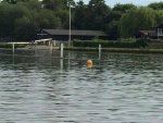
Yellow buoy marker - Henley
- Thread starter thamesS23
- Start date
plumbob
Well-Known Member
Big piece of concrete fallen in.. apparently the contractor who did the new camp shedding threw it in! Town council investigation , apparently.Anyone know what the yellow buoy is for at Henley, I assume it is for an underwater obstruction. Has something sunk there?
Anyone heading to Benson, take care. The weir shoal extends to within 40 ft of a sloping bank. I had .8 under the keel in the centre of what remains useable.
Cashbuyer
Well-Known Member
Big piece of concrete fallen in.. apparently the contractor who did the new camp shedding threw it in! Town council investigation , apparently.
Apparently the concrete is at the Rowing museum. Nothing to do with the Ragatta course, as shown in image.
Time Out
Well-Known Member
That's pretty impressive throwing if it landed there....
TrueBlue
Well-Known Member
There were two such yellow buoys out by the course when we passed yesterday. One as photo'd the other by the judges box. As the course is still under construction, I'm guessing they are there as anchor markers for the construction boats.
In the bad old days when EA did any dredging you could often see something similar (but larger) near their pontoon / barges.
In the bad old days when EA did any dredging you could often see something similar (but larger) near their pontoon / barges.
Ian E
New Member
I did see a third yellow buoy further upstream by the park. Also worth noting that a boat bottomed out in the Henley park where they repaired/reinforced the bank causing a lot of damage, so avoid. I believe there are rocks under the water.
Pump-Out
Well-Known Member
I think you will find that the yellow ones near the course are to warn rowing crews that they are approaching a hazard caused by the course building.
LimL
Well-Known Member
Yes I hit it myself on Saturday. It was the only space available and I was slightly suspicious and approached very slowly. The front of the keel on my steel boat hit it very hard �� . No markings, buoys or anything. This is the one by the park, well upstream of the museum.
zitzeeb
New Member
Have you reported it?No markings, buoys or anything. This is the one by the park, well upstream of the museum.
LimL
Well-Known Member
Do you forumites think this is the responsibility of Henley Town Council? If so I will report tomorrow.Have you reported it?
boatone
Well-Known Member
It is the responsibility of HTC and I was assured by the EA that they had contacted HTC whose contractors had investigated and found no obstructions.Do you forumites think this is the responsibility of Henley Town Council? If so I will report tomorrow.
Precise location is always an issue.
Cashbuyer
Well-Known Member
We also have a warning of shallow water in the Henley and Rowing Museum area up stream, from one of our moorers which may be of help to you.
“We moored alongside the park at the public moorings (as they have done for years) in Henley and enjoyed a nice lunch.
Upon starting engines to leave, it was obvious that we were fouled in some way on the starboard engine and the boat would not move. Turned both engines off and a residents from the adjacent island who saw our predicament came across in their row boat and advised that the mooring side walls had been renewed but that contractors had left large rocks in the water without any warning signs!
With their assistance, by standing all persons except me on the port bow side, we managed to float the boat off but the starboard engine, when started, did not sound correct so I switched it off and started to make for home. Anyway, the warning for all NHMYC members and fellow Harleyford Boat Owners is – do not moor by the new looking mooring side walls (shiny aluminium bottom left in the attached photo) alongside Henley Park as it is not safe for boats! Sealine S37”
Cashbuyer
Well-Known Member

LimL
Well-Known Member
It is the responsibility of HTC and I was assured by the EA that they had contacted HTC whose contractors had investigated and found no obstructions.
Precise location is always an issue.
As promised I did follow this up with Henley Town Council last week. So far not a lot of progress, see correspondence below, but I will keep up the correspodence and pressure until there is a resolution, and report back here.
For info, the person in the Council who seems to be responsible is Karl Bishop, k.bishop@henleytowncouncil.gov.uk.
Sent: 02 June 2017 14:07
Subject: Dangerous underwater obstruction - Mill Meadows park
Dear Karl,
I called earlier and was promised a call-back from you but perhaps you are busy.
I am writing on behalf of myself and the Thames Boating community in our Forum. When attempting to moor last weekend on the Council moorings on the south-west bank of the river, several hundred metres upstream from the RRM, I hit a concrete obstruction, several in number, around 750mm below water level, which was normal at the time.
Since then our forum has reported several serious incidents on the unmarked obstruction which is within 2 metres of the bank and in an area that has recently been re-sheeted; you can see this clearly from the river. I attach a map showing the approximate location.
This is very dangerous and is completely unmarked. Apart from the damage caused to boats, which is likely to be considerable, there is a risk of serious injury if an adult or child passenger is thrown off their boat when coming in to moor and their vessel comes to a sudden stop.
Could you please make immediate arrangements to mark, and then remove this dangerous obstruction. If you let me know your response, I will publicise this on our Forum so that the many Thames boat owners are aware of what Henley Council are doing.
Please feel free to phone me or email back for any further information. If necessary I will attend the site with you to assist.
Regards
Peter Roper
____________________
From: Enquiries [mailto:enquiries@henleytowncouncil.gov.uk]
Sent: 05 June 2017 11:46
Subject: RE: Dangerous underwater obstruction - Mill Meadows park
Good morning
After our telephone conversation I contacted the parks department who informed me that Karl is on leave for a few days and will be back on Wednesday. So if you don’t mind they will be able to discuss this matter with you further then.
Kind regards
Trish Rae
Information Advisor
Henley Town Council
From: Peter Roper [mailto
 eter.roper@btconnect.com]
 Sent: 05 June 2017 12:18
To: Enquiries <enquiries@henleytowncouncil.gov.uk>
Subject: RE: Dangerous underwater obstruction - Mill Meadows park
Sorry, but this is more urgent than that, as there is risk of injury (with probable liability to Henley Town Council now the matter has been formally reported). So I suggest it’s in the Council’s interest to escalate the issue further.
Regards
Peter Roper
05 June 2017
I have forwarded your concerns onto the Town Clerk.
Kind regards
Trish Rae
Information Advisor
AuntyRinum
Well-Known Member
I spoke to one of the Rangers who look after the meadow, mooring fees etc. and they weren't aware of it yesterday.
You can clearly see the lumps of concrete under the water but nobody in authority seems particularly bothered.
You can clearly see the lumps of concrete under the water but nobody in authority seems particularly bothered.
LimL
Well-Known Member
I spoke to one of the Rangers who look after the meadow, mooring fees etc. and they weren't aware of it yesterday.
You can clearly see the lumps of concrete under the water but nobody in authority seems particularly bothered.
I will be following up vigorously with the Town Clerk tomorrow, if any forum members have any further information that would help, or photos, please PM me.
russ
Well-Known Member
I will be following up vigorously with the Town Clerk tomorrow, if any forum members have any further information that would help, or photos, please PM me.
Any more news on this?
LimL
Well-Known Member
Any more news on this?
Well, again I contacted the Town Council this morning, and followed this up with the email below. No response so far except the email reply saying "Thank you for that. I have forwarded your email onto the Town Clerk, the Parks Manager and the Parks Administrator. "
Maybe tomorrow... I'll keep trying. You would think that post-Grenfell all local authorities would be aware of their safety responsibilities.....
Hi Trish, this is the previous correspondence on this subject. Nobody ever contacted me and the problem has not been resolved either, as you can see from this post:
http://www.ybw.com/forums/showthread.php?479451-Yellow-buoy-marker-Henley/page2
I believe it is the responsibility of Henley Town Council to investigate this problem, make sure the area is marked as dangerous, and then arrange to clear the obstructions promptly.
I am happy to assist personally if you need this to identify the exact location of the problem.
Regards
boatone
Well-Known Member
Whilst moored at Henley earlier this week I walked down and inspected the area where the camp shedding has been replaced. The water was fairly clear and I could see no evidence of recent rubble or other fresh deposits. I spoke at length with one of the park employees who was aware of the complaints. I also took quite a few photographs which I have yet to process but which should show the varying nature of the bank side bed and historical obstructions extending up to two feet or so from the bank.
My conclusion was that I could see no evidence of a new hazard here but boaters need to be cautious when mooring and ensure there is adequate depth for their boat. The depth alongside in the stretch upstream from the bandstand is no more than a metre or so close to the bank and normal river levels are stated as being maintained within the range +3" to -6" so can vary significantly. The whole stretch was occupied by moored craft the night I was there,
My conclusion was that I could see no evidence of a new hazard here but boaters need to be cautious when mooring and ensure there is adequate depth for their boat. The depth alongside in the stretch upstream from the bandstand is no more than a metre or so close to the bank and normal river levels are stated as being maintained within the range +3" to -6" so can vary significantly. The whole stretch was occupied by moored craft the night I was there,
Last edited:
apollo
...
It is the responsibility of HTC and I was assured by the EA that they had contacted HTC whose contractors had investigated and found no obstructions.
Precise location is always an issue.
So based on oldgit hitting it, this now proven to be complete load of tosh from EA. I would post on his twitter feed but he seems to have run away and hid!
Other threads that may be of interest
- Replies
- 3
- Views
- 932