simonjk
Well-known member
Hello again,
Thanks to all of you who are using SWIS. Take a look for yourself at http://www.sailingweather.co.uk Forecasts are free and updated 3xper day. This service is developing all the time and I’ll be announcing some exciting enhancements soon.
I’m looking forward to Sailing Weather School being held at the Royal Southampton Yacht Club tomorrow. I will be taking Weather School on the road again later in the year. Plenty of you have emailed asking for a course in Scotland so I will look to arrange this, and after the Southampton course proving so popular I will try to fit another in there too. Let me know if you are interested in either of these.
Onto the weekend forecast, and if you know anyone who’d like to receive this email each week just tell them to send a request to join to
sailingweather-subscribe@weatherweb.net Also, feel free to forward this email to onto any sailing friends or groups.
Have a good weekend,
Simon
WEEKEND WEATHER FORECAST
Issued: 1400 Friday 4th March 2011
SATURDAY
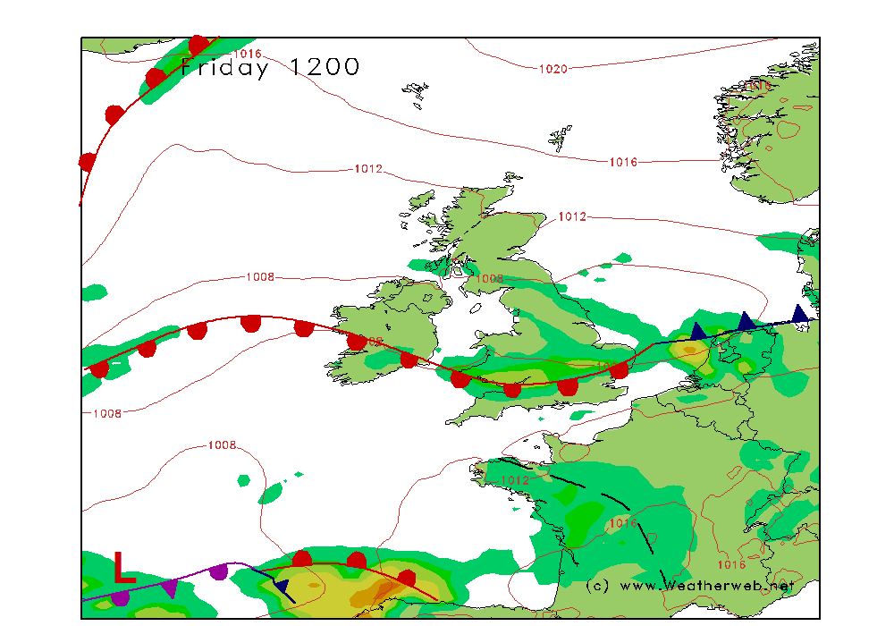
High pressure is going to be situated to the north of Scotland on Saturday, with a cold front pushing southwest through Ireland, Wales, the Midlands and southern England during the day.
Generally it will be a cloudy day with front bringing a fair amount of cloud with it and some outbreaks of mainly light rain. The rain will be focused on the Pennines in the morning, and then drifts into the Midlands and high ground of Wales through the afternoon, before reaching southeast England I the evening.
As the afternoon progresses breaks are expected in the cloud over Scotland and northwest England. . However, northeast England will tend to stay cloudy.
Once of the most favoured areas for sunshine on Saturday will be southwest England.
Visibility will be moderate at times in mist ahead of the front, but should become good behind it.
Winds mainly ENE 10-14kt (F3-F4) ahead of the front, backing NE 8-12kt (F3-F4) behind it.
SUNDAY
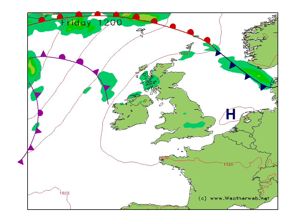
The area of high pressure gets ‘squeezed’ to the south of the country through Sunday as front flow into western Scotland.
My thoughts right now are that cloud is going to be more broken through Sunday for most of the UK and Ireland, with a better chance of most of us seeing some sunny spells. There may be more cloud along southern coasts of England and across the southwest, although it should stay dry.
Thicker cloud associated with the warm front may reach western Scotland, bringing a few spots of rain here, although confidence in this is low.
Winds will be mainly in the E or SE 8-12kt (F3-F4) but perhaps 17-19kt (F5) offshore in the English Channel. Becoming mainly S-SW 9-12kt (F3-F4 over northern England and southern Scotland, SW 20-25kt (F5-F6) in western Scotland later.
***ends***
Thanks to all of you who are using SWIS. Take a look for yourself at http://www.sailingweather.co.uk Forecasts are free and updated 3xper day. This service is developing all the time and I’ll be announcing some exciting enhancements soon.
I’m looking forward to Sailing Weather School being held at the Royal Southampton Yacht Club tomorrow. I will be taking Weather School on the road again later in the year. Plenty of you have emailed asking for a course in Scotland so I will look to arrange this, and after the Southampton course proving so popular I will try to fit another in there too. Let me know if you are interested in either of these.
Onto the weekend forecast, and if you know anyone who’d like to receive this email each week just tell them to send a request to join to
sailingweather-subscribe@weatherweb.net Also, feel free to forward this email to onto any sailing friends or groups.
Have a good weekend,
Simon
WEEKEND WEATHER FORECAST
Issued: 1400 Friday 4th March 2011
SATURDAY
High pressure is going to be situated to the north of Scotland on Saturday, with a cold front pushing southwest through Ireland, Wales, the Midlands and southern England during the day.
Generally it will be a cloudy day with front bringing a fair amount of cloud with it and some outbreaks of mainly light rain. The rain will be focused on the Pennines in the morning, and then drifts into the Midlands and high ground of Wales through the afternoon, before reaching southeast England I the evening.
As the afternoon progresses breaks are expected in the cloud over Scotland and northwest England. . However, northeast England will tend to stay cloudy.
Once of the most favoured areas for sunshine on Saturday will be southwest England.
Visibility will be moderate at times in mist ahead of the front, but should become good behind it.
Winds mainly ENE 10-14kt (F3-F4) ahead of the front, backing NE 8-12kt (F3-F4) behind it.
SUNDAY
The area of high pressure gets ‘squeezed’ to the south of the country through Sunday as front flow into western Scotland.
My thoughts right now are that cloud is going to be more broken through Sunday for most of the UK and Ireland, with a better chance of most of us seeing some sunny spells. There may be more cloud along southern coasts of England and across the southwest, although it should stay dry.
Thicker cloud associated with the warm front may reach western Scotland, bringing a few spots of rain here, although confidence in this is low.
Winds will be mainly in the E or SE 8-12kt (F3-F4) but perhaps 17-19kt (F5) offshore in the English Channel. Becoming mainly S-SW 9-12kt (F3-F4 over northern England and southern Scotland, SW 20-25kt (F5-F6) in western Scotland later.
***ends***