simonjk
Well-Known Member
****
ARE YOU WEATHER WHYS?
Learn more about the weather with my books and DVD's.
See free samples online at http://www.weatherweb.net.books.htm
*****
COME TO WEATHER SCHOOL - FEBRUARY 2013
Due to inclement weather I had to postpone Sailing Weather School (Part 1) until next Saturday 2nd February 2013. There are a couple of places available, and that means that if you have not been to Weather School yet, now is your ideal opportunity. The course runs from 10am to 4pm here in Wombourne and is your chance to learn more about weather, and how to spot those all important sailing weather windows.
To book your place call me on 01902 895252 or book online at www.weatherschool.co.uk .
*****
Hello,
After the cold weather of the past week, things are likely to be warming up this weekend and into next week. However, we've some wintry weather and poor visibility to get out of the way before things improve.
The Sailing Weather Information Service remains ever popular as it enters its third year of operation. You can get your free 14-day trial by registering now at www.sailingweather.co.uk. Remember our forecasts are available by the web, and text message, and they could the UK, Ireland and Europe.
If you have a friend who would like to receive this forecast by email each week ask them to subscribe by emailing sailingweather-subscribe@weatherweb.net
Have a great weekend,
Simon
WEEKEND WEATHER FORECAST
===========================
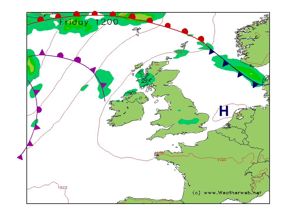
Issued 1100 Thursday 24th January 2013
Saturday:
Low pressure will be to the north of Scotland on Saturday. A brisk southwest flow covers the UK and Ireland, with fronts clearing east. Further fronts will be pushing eastwards through Ireland in the evening, and then across the rest of the country overnight.
Snow may affect East Anglia through the early part of Saturday morning, but this is going to be increasingly turning to rain and ice. More cloud and rain will be affecting the northern and central portions of Scotland, where it will be very windy in the north too. There is a chance of freezing rain across northern England and southern Scotland until early afternoon, this possibly falling as snow.
Rain will be clear other areas through the morning, leaving plenty of cloud for most. The cloud base will be low and visibility will be reduced because of mist bought about by the warmer air arriving from the Atlantic and flowing over the colder ground surfaces.
In the afternoon thicker cloud will be arriving through Ireland and this is going to be pushing rain eastwards through the evening. The winds in creasing in the west once again too.
Winds SE 12-15kt (F4-F5) in the east at first, SW 18-25kt (F5-F6) in the south, SW 20-30kt (F6-F7) in northern Scotland at first, then becoming SW 10-14kt (F3-F4)
Sunday:
Low pressure will be to the west of Ireland through Sunday. An occluded front clears east overnight taking some heavy rain with it. Following will be a brisk, west to southwest flow. Troughs surround the low bringing persistent periods of showers at times.
Rain is likely over the southeast of England and East Anglia on Sunday morning. This is going to be clearing eastwards. However, cloud, rain and showers will follow through Ireland, Wales and the west of the UK. An area of rain may then spill into northern England through the afternoon, turning to snow on the hills, reahcing southern Scotland too.
Drier and brighter weather should reach southern and western areas in the afternoon, although western coasts will always be at risk from a few showers.
Winds SW 20-25kt (F5-F6) but to 30-35kt (F8) in western Ireland.

***ends***
ARE YOU WEATHER WHYS?
Learn more about the weather with my books and DVD's.
See free samples online at http://www.weatherweb.net.books.htm
*****
COME TO WEATHER SCHOOL - FEBRUARY 2013
Due to inclement weather I had to postpone Sailing Weather School (Part 1) until next Saturday 2nd February 2013. There are a couple of places available, and that means that if you have not been to Weather School yet, now is your ideal opportunity. The course runs from 10am to 4pm here in Wombourne and is your chance to learn more about weather, and how to spot those all important sailing weather windows.
To book your place call me on 01902 895252 or book online at www.weatherschool.co.uk .
*****
Hello,
After the cold weather of the past week, things are likely to be warming up this weekend and into next week. However, we've some wintry weather and poor visibility to get out of the way before things improve.
The Sailing Weather Information Service remains ever popular as it enters its third year of operation. You can get your free 14-day trial by registering now at www.sailingweather.co.uk. Remember our forecasts are available by the web, and text message, and they could the UK, Ireland and Europe.
If you have a friend who would like to receive this forecast by email each week ask them to subscribe by emailing sailingweather-subscribe@weatherweb.net
Have a great weekend,
Simon
WEEKEND WEATHER FORECAST
===========================
Issued 1100 Thursday 24th January 2013
Saturday:
Low pressure will be to the north of Scotland on Saturday. A brisk southwest flow covers the UK and Ireland, with fronts clearing east. Further fronts will be pushing eastwards through Ireland in the evening, and then across the rest of the country overnight.
Snow may affect East Anglia through the early part of Saturday morning, but this is going to be increasingly turning to rain and ice. More cloud and rain will be affecting the northern and central portions of Scotland, where it will be very windy in the north too. There is a chance of freezing rain across northern England and southern Scotland until early afternoon, this possibly falling as snow.
Rain will be clear other areas through the morning, leaving plenty of cloud for most. The cloud base will be low and visibility will be reduced because of mist bought about by the warmer air arriving from the Atlantic and flowing over the colder ground surfaces.
In the afternoon thicker cloud will be arriving through Ireland and this is going to be pushing rain eastwards through the evening. The winds in creasing in the west once again too.
Winds SE 12-15kt (F4-F5) in the east at first, SW 18-25kt (F5-F6) in the south, SW 20-30kt (F6-F7) in northern Scotland at first, then becoming SW 10-14kt (F3-F4)
Sunday:
Low pressure will be to the west of Ireland through Sunday. An occluded front clears east overnight taking some heavy rain with it. Following will be a brisk, west to southwest flow. Troughs surround the low bringing persistent periods of showers at times.
Rain is likely over the southeast of England and East Anglia on Sunday morning. This is going to be clearing eastwards. However, cloud, rain and showers will follow through Ireland, Wales and the west of the UK. An area of rain may then spill into northern England through the afternoon, turning to snow on the hills, reahcing southern Scotland too.
Drier and brighter weather should reach southern and western areas in the afternoon, although western coasts will always be at risk from a few showers.
Winds SW 20-25kt (F5-F6) but to 30-35kt (F8) in western Ireland.
***ends***