simonjk
Well-Known Member
Good morning,
Right on cue the weather looks set to head downhill (at least for the south of the country) this weekend, although Scotland and Ireland should enjoy better days.
I have one place left on Sailing Weather School (Part 1) this weekend, to be held on Saturday 17th March from 10am to 4pm here in Wombourne. So, if you would like to take advantage of the yukky weather and top up on your weather knowledge in a really friendly atmosphere, this is the ideal chance to do so. The course costs £125 and includes all refreshments and lunch. It's a really enjoyable day. To find out more and book your place go to http://www.weatherschool.co.uk or call 01902 895252.
The Sailing Weather Information Service is becoming ever more popular and you can get your free 14-day trial now. Forecasts are available via the web and text message for the UK, Ireland and Europe. Register now at http://www.sailingweather.co.uk
If you have a friend who would like to receive this forecast by email each week ask them to subscribe by emailing sailingweather-subscribe@weatherweb.net.
Have a great weekend,
Simon
WEEKEND WEATHER FORECAST
===========================
Issued 0900 Thursday 15th March 2012
Saturday:
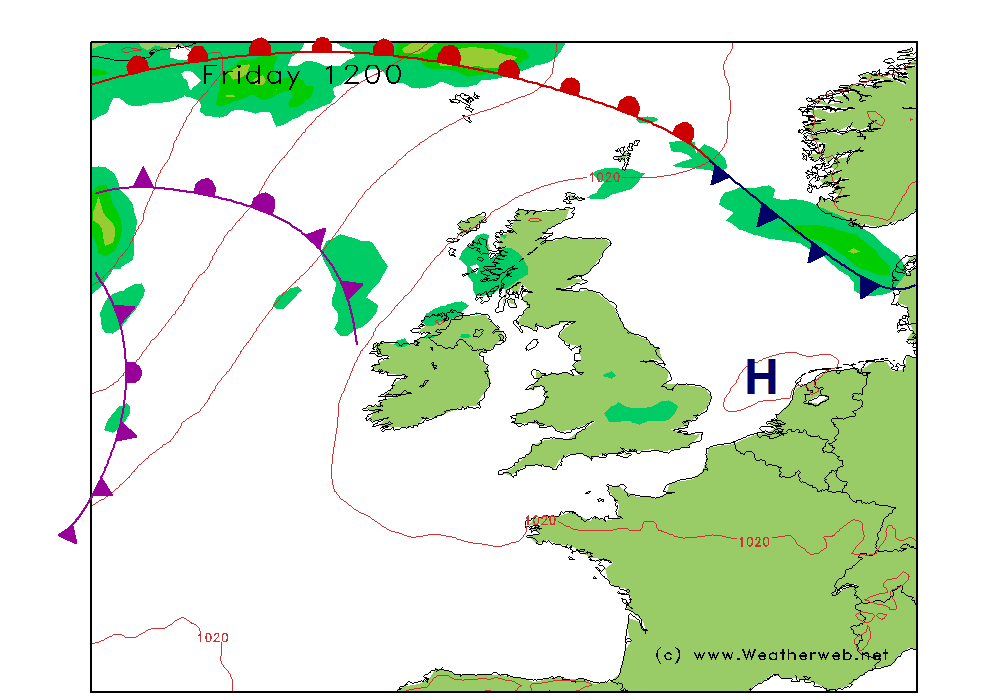
An area of low pressure is going to be crossing the south of the UK on Saturday. This is a developing feature which will take associated fronts eastwards with it. A slack pressure flow affects more northern and western areas.
For England and Wales there will be outbreaks of rain and low cloud through Saturday as the low passes east. It is likely to be turning more showery from the west from late morning, although more persistent rain tending to drift back into northern England through the day. Mist and murk affecting southern areas too, slowly clearing in the afternoon as the showers arrive.
Scotland and Ireland should be mainly dry with sunny spells, although there is the risk of some showers affecting western coasts from time to mtime.
Winds mainly cyclonic 7-12kt (F2-F3) in the south, mainly W-SW 8-10kt (F2) in the north, although SW 12-16kt (F4) in the English Channel.
Sunday:
A ridge of high pressure builds from the west through Sunday bringing a general improvement in conditions. A northwest flow affecting eastern coasts with an occluded front in northeast Scotland. The remnants of Saturday's low look set to continue to affect East Anglia and the far southeast throughout the day.
So a dull day across southeast England and East Anglia with some periods of rain at times; low cloud and poor visibility. There could be more persistent showers or rain in northern and eastern Scotland too.
Further west conditions will be much improved with better visibility and an increased cloud base. It should be dry overall with some sunny spells.
Winds mainly NW 12-17kt (F4-F5) but N 18-24kt (F5-F6) in the English Channel.

***ends***
Right on cue the weather looks set to head downhill (at least for the south of the country) this weekend, although Scotland and Ireland should enjoy better days.
I have one place left on Sailing Weather School (Part 1) this weekend, to be held on Saturday 17th March from 10am to 4pm here in Wombourne. So, if you would like to take advantage of the yukky weather and top up on your weather knowledge in a really friendly atmosphere, this is the ideal chance to do so. The course costs £125 and includes all refreshments and lunch. It's a really enjoyable day. To find out more and book your place go to http://www.weatherschool.co.uk or call 01902 895252.
The Sailing Weather Information Service is becoming ever more popular and you can get your free 14-day trial now. Forecasts are available via the web and text message for the UK, Ireland and Europe. Register now at http://www.sailingweather.co.uk
If you have a friend who would like to receive this forecast by email each week ask them to subscribe by emailing sailingweather-subscribe@weatherweb.net.
Have a great weekend,
Simon
WEEKEND WEATHER FORECAST
===========================
Issued 0900 Thursday 15th March 2012
Saturday:
An area of low pressure is going to be crossing the south of the UK on Saturday. This is a developing feature which will take associated fronts eastwards with it. A slack pressure flow affects more northern and western areas.
For England and Wales there will be outbreaks of rain and low cloud through Saturday as the low passes east. It is likely to be turning more showery from the west from late morning, although more persistent rain tending to drift back into northern England through the day. Mist and murk affecting southern areas too, slowly clearing in the afternoon as the showers arrive.
Scotland and Ireland should be mainly dry with sunny spells, although there is the risk of some showers affecting western coasts from time to mtime.
Winds mainly cyclonic 7-12kt (F2-F3) in the south, mainly W-SW 8-10kt (F2) in the north, although SW 12-16kt (F4) in the English Channel.
Sunday:
A ridge of high pressure builds from the west through Sunday bringing a general improvement in conditions. A northwest flow affecting eastern coasts with an occluded front in northeast Scotland. The remnants of Saturday's low look set to continue to affect East Anglia and the far southeast throughout the day.
So a dull day across southeast England and East Anglia with some periods of rain at times; low cloud and poor visibility. There could be more persistent showers or rain in northern and eastern Scotland too.
Further west conditions will be much improved with better visibility and an increased cloud base. It should be dry overall with some sunny spells.
Winds mainly NW 12-17kt (F4-F5) but N 18-24kt (F5-F6) in the English Channel.
***ends***
Last edited:

")