simonjk
Well-Known Member
Good morning,
Well, it actually feels like spring outside, let's hope you can get some sailing in this weekend.
Now is the time to get your free 14-day trial of the Sailing Weather Information Service . This is becoming ever more popular amongst sailors who want forecasts for their sailing areas by web, email and SMS and vovering the UK, Ireland and Europe. Get your free trail by registering now at www.sailingweather.co.uk.
We will be here all weekend, you can talk to a forecaster live between 8am and 6pm on 0906 515 0046 (calls cost £1.53 per minute) and get a forecasts specifically for you (both myself and John are manning the lines this weekend).
If you have a friend who would like to receive this forecast by email each week ask them to subscribe by emailing sailingweather-subscribe@weatherweb.net
Have a great weekend,
Simon
WEEKEND WEATHER FORECAST
===========================
Issued 1300 Thursday 18th April 2013
Saturday:
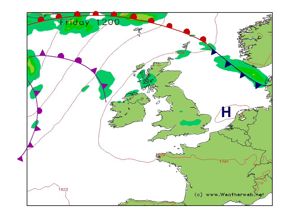
High pressure will be centred over the south of the country on Saturday. Weak fronts will be to the north and west of Scotland and Ireland throughout the day.
It should be a largely fair day through England and Wales, once any morning mist and isolated fog patches have cleared. The sun will be breaking through the cloud and it should be dry.
Across Ireland and the north and west of Scotland there will be more cloud and some showers or patchy rain here with some cloud on the hills and coasts. More eastern and southern parts of Scotland should be staying dry.
Winds variable, mainly S-SW 5-8kt (F2) in the south, SW 10-15kt (F3-4) in the west and north, but nearer SW 18-24kt (F5-F6) in western Scotland and western Ireland.
Sunday:
A ridge of high pressure extends through southern England on Sunday. A cold front will be passing east over Scotland and Ireland, heading to Wales and northwest England in the afternoon, weakening as it passes through eastern England overnight.
It should be a mainly fair day across East Anglia, the eastern Midlands and southern England with broken cloud and dry conditions. Increasing cloud over southwest England, the western Midlands, east Wales and northeast England bringing some rain in the afternoon here, after a dry morning.
More persistent rain in Scotland, northwest England and west Wales through the morning as the front edges east, and don't be surprised to hear an odd crack of thundery along it.
Turning much brighter over Ireland and western Scotland with scattered showers in the afternoon.
Winds mainly SW 8-10kt (F2-F3) in the southeast, indreasing SW-WSW 14-19kt (F4-F5) in the north and west, with gusty winds running ahead of the front.

***ends***
Well, it actually feels like spring outside, let's hope you can get some sailing in this weekend.
Now is the time to get your free 14-day trial of the Sailing Weather Information Service . This is becoming ever more popular amongst sailors who want forecasts for their sailing areas by web, email and SMS and vovering the UK, Ireland and Europe. Get your free trail by registering now at www.sailingweather.co.uk.
We will be here all weekend, you can talk to a forecaster live between 8am and 6pm on 0906 515 0046 (calls cost £1.53 per minute) and get a forecasts specifically for you (both myself and John are manning the lines this weekend).
If you have a friend who would like to receive this forecast by email each week ask them to subscribe by emailing sailingweather-subscribe@weatherweb.net
Have a great weekend,
Simon
WEEKEND WEATHER FORECAST
===========================
Issued 1300 Thursday 18th April 2013
Saturday:
High pressure will be centred over the south of the country on Saturday. Weak fronts will be to the north and west of Scotland and Ireland throughout the day.
It should be a largely fair day through England and Wales, once any morning mist and isolated fog patches have cleared. The sun will be breaking through the cloud and it should be dry.
Across Ireland and the north and west of Scotland there will be more cloud and some showers or patchy rain here with some cloud on the hills and coasts. More eastern and southern parts of Scotland should be staying dry.
Winds variable, mainly S-SW 5-8kt (F2) in the south, SW 10-15kt (F3-4) in the west and north, but nearer SW 18-24kt (F5-F6) in western Scotland and western Ireland.
Sunday:
A ridge of high pressure extends through southern England on Sunday. A cold front will be passing east over Scotland and Ireland, heading to Wales and northwest England in the afternoon, weakening as it passes through eastern England overnight.
It should be a mainly fair day across East Anglia, the eastern Midlands and southern England with broken cloud and dry conditions. Increasing cloud over southwest England, the western Midlands, east Wales and northeast England bringing some rain in the afternoon here, after a dry morning.
More persistent rain in Scotland, northwest England and west Wales through the morning as the front edges east, and don't be surprised to hear an odd crack of thundery along it.
Turning much brighter over Ireland and western Scotland with scattered showers in the afternoon.
Winds mainly SW 8-10kt (F2-F3) in the southeast, indreasing SW-WSW 14-19kt (F4-F5) in the north and west, with gusty winds running ahead of the front.
***ends***