River Thames Guide app - user feedback requested

Rascal Joe

Member
Joined
16 Jun 2013
Messages
257
Location
Ascot
www.jeffmaynard.com
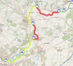
Later this years I will be releasing a version of the River Thames Guide App that can show which river stretches have red or yellow stream warnings (see demo screengrab below).
I have yet to decide:
  1. should the red/yellow always show when map is opened (Note: no overlay for no warnings)?
  2. should the red/yellow only show the first time the map is opened each session?
  3. should the warnings only be overlayed when explicitly selected by the user?
Secondly, would it help to have, say, dark yellow for Stream Increasing and light yellow for Stream Decreasing? (that's another several hundred lines of code so user feedback is important).

Selection (or otters suggestions) welcome...
Screenshot 1.png
 

Bran

Active member
Joined
27 Mar 2012
Messages
445
Location
Bedfordshire and Surrey
Visit site
In answer to your questions, my view is:
1: red yellow should always show when opening the map.
Personally I think just having the map sections highlighted in yellow or red is enough, no need for stream increasing or decreasing. It brings the river state to the users attention and they can can then go on to investigate further if needed.
Maybe just have an overlay key on the map page to take the user to the EA conditions page. Probably useful to have that anyway with all the lock breakdowns and restrictions as this is the page the EA have decided is where all the up to date information is kept.

It’s a great app so many thanks for all your work on this, I know the river well but often use the map, journey planning or lock data.
Just the other week one lock gate would not open, a widebeam was desperate to get through for a medical appointment. His width was 10 ft, looked up data, shows lock at 21 ft wide, gates were at full width of the lock so we got him through.
 

Rascal Joe

Member
Joined
16 Jun 2013
Messages
257
Location
Ascot
www.jeffmaynard.com
In answer to your questions, my view is:
1: red yellow should always show when opening the map.
Personally I think just having the map sections highlighted in yellow or red is enough, no need for stream increasing or decreasing. It brings the river state to the users attention and they can can then go on to investigate further if needed.
Maybe just have an overlay key on the map page to take the user to the EA conditions page. Probably useful to have that anyway with all the lock breakdowns and restrictions as this is the page the EA have decided is where all the up to date information is kept.

It’s a great app so many thanks for all your work on this, I know the river well but often use the map, journey planning or lock data.
Just the other week one lock gate would not open, a widebeam was desperate to get through for a medical appointment. His width was 10 ft, looked up data, shows lock at 21 ft wide, gates were at full width of the lock so we got him through.
Thanks for the response - will take into account when finishing the update.
The current EA conditions can be reached from the app (Home/Current Conditions)
 
Top